SAR Halls Well
From TrainzOnline
(Difference between revisions)
m |
m |
||
| (10 intermediate revisions by one user not shown) | |||
| Line 8: | Line 8: | ||
</tr> | </tr> | ||
<tr valign="top"> | <tr valign="top"> | ||
| − | <td align="center">[[image:Tab_HM_White.png|link=]] [[image:Tab_IN_Grey.png|link=SAR_Halls_Well_Industry]] [[image: | + | <td align="center">[[image:Tab_HM_White.png|link=]] [[image:Tab_IN_Grey.png|link=SAR_Halls_Well_Industry]] [[image:Tab_TM_Grey.png|link=SAR_Halls_Well_Trackmarks]] [[image:Tab_Blank_Grey.png|link=]] [[image:Tab_Blank_Grey.png|link=]]</td> |
</tr> | </tr> | ||
<tr valign="top"> | <tr valign="top"> | ||
| Line 20: | Line 20: | ||
<td width=220 align="right">[[Image:SAR_Peterborough-Quorn_Line.png|link=SAR Peterborough-Quorn|alt=Peterborough-Quorn Line|Show Peterborough-Quorn Line]]</td> | <td width=220 align="right">[[Image:SAR_Peterborough-Quorn_Line.png|link=SAR Peterborough-Quorn|alt=Peterborough-Quorn Line|Show Peterborough-Quorn Line]]</td> | ||
<td width=110 align="center">[[Image:Next Left.png|link=|alt=]]<br>[[Image:SAR_Wallaway_Name.png|link=SAR Wallaway|alt=Wallaway|Next Up Location]]</td> | <td width=110 align="center">[[Image:Next Left.png|link=|alt=]]<br>[[Image:SAR_Wallaway_Name.png|link=SAR Wallaway|alt=Wallaway|Next Up Location]]</td> | ||
| − | <td width=90 align="center">[[Image:Location Index.png|link=SAR Index|alt=Location Index|Location Index]]</td> | + | <td width=90 align="center">[[Image:Location Index.png|link=SAR Index|alt=Location Index|Location Index]]<br>[[image:Scenario Index.png|link=SAR Peterborough Base Session|alt=Scenarios|Scenario Index]]</td> |
<td width=110 align="center">[[Image:Next Right.png|link=|alt=]]<br>[[Image:SAR_Eurelia_Name.png|link=SAR Eurelia|alt=Eurelia|Next Down Location]]</td> | <td width=110 align="center">[[Image:Next Right.png|link=|alt=]]<br>[[Image:SAR_Eurelia_Name.png|link=SAR Eurelia|alt=Eurelia|Next Down Location]]</td> | ||
<td width=220 align="left">[[Image:SAR_Peterborough-Quorn_Line.png|link=SAR Peterborough-Quorn|alt=Peterborough-Quorn Line|Show Peterborough-Quorn Line]]</td> | <td width=220 align="left">[[Image:SAR_Peterborough-Quorn_Line.png|link=SAR Peterborough-Quorn|alt=Peterborough-Quorn Line|Show Peterborough-Quorn Line]]</td> | ||
| Line 74: | Line 74: | ||
<tr valign="top"> | <tr valign="top"> | ||
<td width=750> | <td width=750> | ||
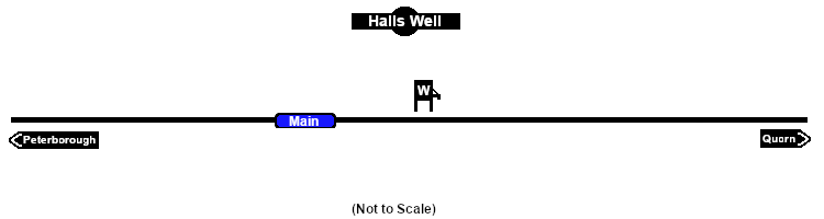
| + | <span style="font-weight: 700;"><span style="color: white; background-color: black;"> Distance from Peterborough: </span> 51½ kms, 32 miles</span><br> | ||
| + | |||
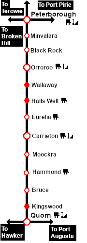
Unmanned location on the <span style="font-weight: 700; color: white; background-color: black;"> Peterborough-Quorn Line </span>.<br> | Unmanned location on the <span style="font-weight: 700; color: white; background-color: black;"> Peterborough-Quorn Line </span>.<br> | ||
| − | No sidings or loops. | + | A water tower on the main line. No sidings or loops.<br> |
| + | |||
| + | The tank was filled with water from a well which was purchased from a Mr Hall in 1897 (hence the name '''Halls Well''') and was notable as being the only source of underground water used by the '''SAR'''. It was mostly used as a "top-up" for freight trains making the long climb from '''Orroroo''' to '''Eurelia''' which has some of the steepest grades on the line. | ||
</td> | </td> | ||
</tr> | </tr> | ||
Latest revision as of 09:48, 8 September 2022
|
 |