SAR Halls Well
From TrainzOnline
(Difference between revisions)
(Created page with "alt=Halls Well<br> Main Line with a water tower. Unmanned location on the Peterborough to Quorn cross country line. <table> <tr valign="t...") |
m |
||
| Line 1: | Line 1: | ||
| − | [[Image:SAR_Halls_Well.png|link= |alt=Halls Well]]<br> | + | [[Image:SAR_Halls_Well.png|link=|alt=Halls Well]]<br> |
Main Line with a water tower. Unmanned location on the Peterborough to Quorn cross country line. | Main Line with a water tower. Unmanned location on the Peterborough to Quorn cross country line. | ||
| Line 9: | Line 9: | ||
<tr valign="middle"> | <tr valign="middle"> | ||
<td width=330 align="right">[[Image:SAR_Peterborough-Quorn_Line.png|link=SAR Peterborough-Quorn Line|alt=Peterborough-Quorn Line|Show Peterborough-Quorn Line]] [[Image:SAR_Wallaway_Name.png|link=SAR Wallaway|alt=Wallaway|Next Up Location]]</td> | <td width=330 align="right">[[Image:SAR_Peterborough-Quorn_Line.png|link=SAR Peterborough-Quorn Line|alt=Peterborough-Quorn Line|Show Peterborough-Quorn Line]] [[Image:SAR_Wallaway_Name.png|link=SAR Wallaway|alt=Wallaway|Next Up Location]]</td> | ||
| − | <td width=90 align="center">[[Image:Location Index.png|link=SAR Index |alt=Location Index | | + | <td width=90 align="center">[[Image:Location Index.png|link=SAR Index|alt=Location Index|Location Index]]</td> |
| − | <td width=330 align="left">[[Image:SAR_Eurelia_Name.png|link=SAR Eurelia |alt=Eurelia |Next Down Location]] [[Image:SAR_Peterborough-Quorn_Line.png|link=SAR Peterborough-Quorn Line|alt=Peterborough-Quorn Line|Show Peterborough-Quorn Line]]</td> | + | <td width=330 align="left">[[Image:SAR_Eurelia_Name.png|link=SAR Eurelia|alt=Eurelia|Next Down Location]] [[Image:SAR_Peterborough-Quorn_Line.png|link=SAR Peterborough-Quorn Line|alt=Peterborough-Quorn Line|Show Peterborough-Quorn Line]]</td> |
</tr> | </tr> | ||
</table> | </table> | ||
<table bgcolor="LightYellow"> | <table bgcolor="LightYellow"> | ||
<tr> | <tr> | ||
| − | <td colspan=6 align="center">[[Image:line740.png|link= ]]</td> | + | <td colspan=6 align="center">[[Image:line740.png|link=]]</td> |
</tr> | </tr> | ||
<tr valign="top"> | <tr valign="top"> | ||
| Line 26: | Line 26: | ||
</tr> | </tr> | ||
<tr valign="middle"> | <tr valign="middle"> | ||
| − | <td colspan=6 align="center">[[Image:line740.png|link= ]]</td> | + | <td colspan=6 align="center">[[Image:line740.png|link=]]</td> |
</tr> | </tr> | ||
<tr> | <tr> | ||
| Line 32: | Line 32: | ||
</tr> | </tr> | ||
<tr valign="middle"> | <tr valign="middle"> | ||
| − | <td colspan=6 align="center">[[Image:line740.png|link= ]]</td> | + | <td colspan=6 align="center">[[Image:line740.png|link=]]</td> |
</tr> | </tr> | ||
</table></td> | </table></td> | ||
<td> | <td> | ||
| − | [[file:SAR_Peterborough-Quorn Strip Map.png|link= |alt=Peterborough-Quorn Strip Map ]]</td> | + | [[file:SAR_Peterborough-Quorn Strip Map.png|link=|alt=Peterborough-Quorn Strip Map]]</td> |
</tr> | </tr> | ||
</table> | </table> | ||
Revision as of 23:14, 14 April 2019
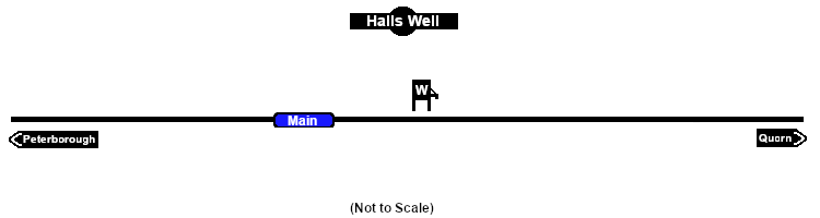
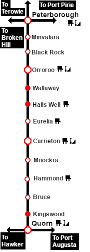
Main Line with a water tower. Unmanned location on the Peterborough to Quorn cross country line.
|
 |
|||||||||||||||||||||||||||||||||
