SAR Paratoo Industry V1

From TrainzOnline
Revision as of 01:46, 29 April 2024 by Pware (Talk | contribs)

Jump to: navigation, search
Line740.png
Tab HM Grey.png Tab IN White.png Tab TM Grey.png Tab SW Grey.png Tab Blank Grey.png
Line740.png
PortPirie-BrokenHill
Methuen
Location Index
Scenarios
  PortPirie-BrokenHill
SAR Paratoo Industry V1.png
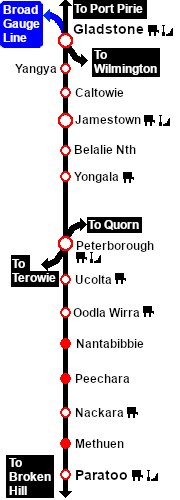
This is the original v1.0 Paratoo Map and description. For the latest SAR Peterborough Narrow Gauge Division v2.0 version click here. The V2.0 version of the route and sessions requires Trainz Plus or TRS22
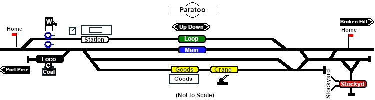
Line740.png
 Industries 
For the Station use the "Drive To Trackmark name of Trackmark" command
Line740.png
Passenger Icon off.png  Station Label.png TM Paratoo Station Up     TM Paratoo Station Dn
                  This station is NOT passenger enabled
Line740.png
For all other Industries use the "Drive To name of industry" and "Load/Unload" commands
Line740.png
Goods Icon.png Goods Label.png Paratoo Goods Shed
  • General Goods - Unload
  • Fertiliser Bagged - Unload
  • Wool Bale - Load
  Crane Label.png Paratoo Goods Crane
  • Farm Equipment - Unload
  • I-Beams - Unload
  • John Deere Tractor Product - Unload
  • Lumber - Unload
Line740.png
Livestock Icon.png Stockyard Label.png Paratoo Stockyard
  • Cattle - Load/Unload
  • Sheep - Load/Unload
Line740.png
Water Icon.png Main Label.png WaterColumn.png Paratoo Water Column Main Up
  • Water - Load
  Loop Label.png WaterColumn.png Paratoo Water Column Loop Up
  • Water - Load
Line740.png
Coal Icon.png Loco Label.png Paratoo Coal Stage
  • Coal - Load/Unload
Line740.png

PortPirie-BrokenHill

Gladstone-Paratoo Strip Map