|
|
| (21 intermediate revisions by one user not shown) |
| Line 3: |
Line 3: |
| | <td width=750> | | <td width=750> |
| | | | |
| − | <table bgcolor="lightgrey" bordercolor="lightgrey" width=750> <!-- BEGIN Location details table --> | + | <table width=750> <!-- BEGIN TABBED link list with Home page active--> |
| | + | <tr valign="top"> |
| | + | <td align="center">[[Image:line740.png|link=]]</td> |
| | + | </tr> |
| | + | <tr valign="top"> |
| | + | <td align="center">[[image:Tab_HM_White.png|link=]] [[image:Tab_IN_Grey.png|link=SAR_Minvalara_Industry]] [[image:Tab_TM_Grey.png|link=SAR_Minvalara_TrackMarks]] [[image:Tab_SW_Grey.png|link=SAR_Minvalara_Switches]] [[image:Tab_Blank_Grey.png|link=]]</td> |
| | + | </tr> |
| | + | <tr valign="top"> |
| | + | <td align="center">[[Image:line740.png|link=]]</td> |
| | + | </tr> |
| | + | </table> <!-- END TABBED link list --> |
| | + | |
| | + | <table bgcolor="lightgrey" bordercolor="lightgrey" width=750> <!-- BEGIN Location link table with LINE and STATION NAMES --> |
| | | | |
| | <tr valign="middle"> | | <tr valign="middle"> |
| | <td width=220 align="right">[[Image:SAR_Peterborough-Quorn_Line.png|link=SAR Peterborough-Quorn|alt=Peterborough-Quorn|Show Peterborough-Quorn]]</td> | | <td width=220 align="right">[[Image:SAR_Peterborough-Quorn_Line.png|link=SAR Peterborough-Quorn|alt=Peterborough-Quorn|Show Peterborough-Quorn]]</td> |
| | <td width=110 align="center">[[Image:Next Left.png|link=|alt=]]<br>[[Image:SAR_Peterborough_B_Name.png|link=SAR Peterborough|alt=Peterborough|Next Up Location]]</td> | | <td width=110 align="center">[[Image:Next Left.png|link=|alt=]]<br>[[Image:SAR_Peterborough_B_Name.png|link=SAR Peterborough|alt=Peterborough|Next Up Location]]</td> |
| − | <td width=90 align="center">[[Image:Location Index.png|link=SAR Index|alt=Location Index|Location Index]]</td> | + | <td width=90 align="center">[[Image:Location Index.png|link=SAR Index|alt=Location Index|Location Index]]<br>[[image:Scenario Index.png|link=SAR Peterborough Base Session|alt=Scenarios|Scenario Index]]</td> |
| | <td width=110 align="center">[[Image:Next Right.png|link=|alt=]]<br>[[Image:SAR_Black_Rock_Name.png|link=SAR Black Rock|alt=Black Rock|Next Down Location]]</td> | | <td width=110 align="center">[[Image:Next Right.png|link=|alt=]]<br>[[Image:SAR_Black_Rock_Name.png|link=SAR Black Rock|alt=Black Rock|Next Down Location]]</td> |
| | <td width=220 align="left">[[Image:SAR_Peterborough-Quorn_Line.png|link=SAR Peterborough-Quorn|alt=Peterborough-Quorn|Show Peterborough-Quorn]]</td> | | <td width=220 align="left">[[Image:SAR_Peterborough-Quorn_Line.png|link=SAR Peterborough-Quorn|alt=Peterborough-Quorn|Show Peterborough-Quorn]]</td> |
| | </tr> | | </tr> |
| − | <tr valign="top">
| |
| − | <td colspan=2><span style="font-weight: 700;"><span style="background-color: black; color: white;"> Commodities: </span> (load and/or unload)</span>
| |
| | | | |
| − | <table> <!-- BEGIN Commodities Table --> | + | </table> <!-- END Location link table with LINE and STATION NAMES --> |
| − | <tr valign="top">
| + | |
| − | <td align="center">[[Image:Passenger_Icon.png|link=|alt=Passengers]]<br><span style="font-size: 10px; font-weight: 700;">Passengers</span><br>[[image:Station_Label.png|link=]]</td>
| + | |
| − | </tr>
| + | |
| − | </table> <!-- END Commodities Table -->
| + | |
| | | | |
| − | </td>
| + | [[image:SAR_Minvalara.png|link=|alt=Minvalara map]] |
| − | <td colspan=2><span style="font-weight: 700;"><span style="background-color: black; color: white;"> Facilities: </span></span> | + | |
| | + | <table bgcolor="lightgrey" bordercolor="lightgrey" width=750> <!-- BEGIN Location details table --> |
| | | | |
| − | <table> <!-- BEGIN Facilities Table -->
| |
| | <tr valign="top"> | | <tr valign="top"> |
| − | <td align="center">[[Image:Loop_Icon.png|link=|alt=Loop]]<br><span style="font-size: 10px; font-weight: 700;">Loop</span></td> | + | <td><span style="font-weight: 700; background-color: black; color: white;"> Commodities: </span> |
| − | </tr>
| + | |
| − | </table> <!-- END Facilities Table -->
| + | |
| | | | |
| − | </td> | + | <table width=300> <!-- BEGIN Commodities table (5 items) --> |
| − | </tr> | + | <tr valign="top"> |
| | | | |
| − | </table> <!-- END Location details table --> | + | <td align="center" width=50>[[Image:Passenger_Icon_off.png|link=|alt=Passengers]]<br><span style="font-size: 10px; font-weight: 700;">Passengers</span><br>[[image:Station_Label.png|link=]]</td> |
| | + | <td align="center" width=50> </td> <!-- holding space 2 --> |
| | + | <td align="center" width=50> </td> <!-- holding space 3 --> |
| | + | <td align="center" width=50> </td> <!-- holding space 4 --> |
| | + | <td align="center" width=50> </td> <!-- holding space 5 --> |
| | | | |
| − | <table> <!-- BEGIN Information Table --> | + | </tr> |
| | + | </table> <!-- END Commodities Table --> |
| | | | |
| − | <tr valign="top">
| |
| − | <td width=750>
| |
| − | Passing/station loop. Unmanned station on the <span style="font-weight: 700; color: white; background-color: black;"> Peterborough-Quorn Line </span>.
| |
| | </td> | | </td> |
| − | </tr> | + | <td> |
| | | | |
| | + | <table width=175> <!-- BEGIN Loco table (3 items) --> |
| | <tr valign="top"> | | <tr valign="top"> |
| − | <td align="center">[[Image:line740.png|link=]]</td>
| |
| − | </tr>
| |
| | | | |
| − | </table> <!-- END Information Table --> | + | <td width=175> </td> <!-- holding space 1-3 for no Loco items - REMOVE black background and "Loco Serices" label --> |
| | | | |
| − | <table width=750> <!-- BEGIN Track Diagram & Markers Title Link -->
| |
| − | <tr valign="top">
| |
| − | <td width=450>{{Anchor|TMData}}<span style="font-weight: 700; font-size: 18px; background-color: blue; color: white;"> Track Markers </span></td>
| |
| − | <td align="right" width=300>[[image:ToPathsDown.png|link=#PathData]] [[file:BackToTop.png|link=#top]] [[file:BackToBottom.png|link=#BaseData]]</td>
| |
| | </tr> | | </tr> |
| − | </table> <!-- END Track Diagram & Markers Title Link --> | + | </table> <!-- END Loco table --> |
| | | | |
| − | [[Image:SAR_Minvalara_Basic.png|link=|alt=Minvalara Track Diagram/Markers Map]]<br> <!-- TD/TM map -->
| + | </td> |
| | + | <td><span style="font-weight: 700;"><span style="background-color: black; color: white;"> Facilities: </span></span> |
| | | | |
| − | <table bgcolor="LightYellow" width=750> <!-- BEGIN Track Markers table --> | + | <table width=250> <!-- BEGIN Facilities table (4 items) --> |
| | <tr valign="top"> | | <tr valign="top"> |
| − | <td colspan=3 align="center">[[Image:line740.png|link=]]</td>
| |
| − | </tr>
| |
| − | <tr valign="middle">
| |
| − | <td colspan=3 align="center"><span style="font-weight: 700;font-size: 17px; background-color: red; color: white;"> Track Markers </span></td>
| |
| − | </tr>
| |
| − | <tr valign="middle">
| |
| − | <td colspan=3 align="center"><span style="font-weight: 700;">Destinations for "Drive To Trackmark ..." commands</span></td>
| |
| − | </tr>
| |
| − | <tr valign="middle">
| |
| − | <td width=200><span style="font-weight: 700; background-color: black; color: white;"> Approach from Peterborough </span> </td>
| |
| − | <td colspan=2>[[image:Trackmark_Right.png|link=|alt=TM|10px]] <span style="font-weight: 700;">Minvalara Main Approach Dn</span></td>
| |
| − | </tr>
| |
| − | <tr valign="middle">
| |
| − | <td width=200><span style="font-weight: 700; background-color: black; color: white;"> Approach from Quorn </span> </td>
| |
| − | <td colspan=2>[[image:Trackmark_Left.png|link=|alt=TM|10px]] <span style="font-weight: 700;">Minvalara Main Approach Up</span></td>
| |
| − | </tr>
| |
| − | <tr valign="middle">
| |
| − | <td width=200>[[image:Station_Label.png|link=|alt=Station]] </td>
| |
| − | <td>[[image:Trackmark_Left.png|link=|alt=TM|10px]] <span style="font-weight: 700;">Minvalara Station Up</span></td>
| |
| − | <td>[[image:Trackmark_Right.png|link=|alt=TM|10px]] <span style="font-weight: 700;">Minvalara Station Dn</span></td>
| |
| − | </tr>
| |
| − | <tr valign="middle">
| |
| − | <td width=200>[[image:Loop_Label.png|link=|alt=Loop]] </td>
| |
| − | <td>[[image:Trackmark_Left.png|link=|alt=TM|10px]] <span style="font-weight: 700;">Minvalara Station Loop Up</span></td>
| |
| − | <td>[[image:Trackmark_Right.png|link=|alt=TM|10px]] <span style="font-weight: 700;">Minvalara Station Loop Dn</span></td>
| |
| − | </tr>
| |
| − | <tr valign="middle">
| |
| − | <td width=200>[[image:Main_Label.png|link=|alt=Main]] </td>
| |
| − | <td>[[image:Trackmark_Left.png|link=|alt=TM|10px]] <span style="font-weight: 700;">Minvalara Main Up</span></td>
| |
| − | <td>[[image:Trackmark_Right.png|link=|alt=TM|10px]] <span style="font-weight: 700;">Minvalara Main Dn</span></td>
| |
| − | </tr>
| |
| − | <tr valign="top">
| |
| − | <td colspan=3 align="center">[[Image:line740.png|link=]]</td>
| |
| − | </tr>
| |
| − | </table> <!-- END Track Markers table -->
| |
| | | | |
| − | <table bgcolor="LightYellow" width=750> <!-- BEGIN Switches table --> | + | <td align="center" width=50>[[Image:Loop_Icon.png|link=|alt=Loop]]<br><span style="font-size: 10px; font-weight: 700;">Loop</span><br>[[image:Loop_Label.png|link=]]</td> |
| | + | <td align="center" width=50> </td> <!-- holding space 2 --> |
| | + | <td align="center" width=50> </td> <!-- holding space 3 --> |
| | + | <td align="center" width=50> </td> <!-- holding space 4 --> |
| | | | |
| − | <!-- Insert Switches/Switch Sets details -->
| |
| − |
| |
| − | </table> <!-- END Switches table -->
| |
| − |
| |
| − | <table width=750> <!-- BEGIN Path Map Table -->
| |
| − | <tr valign="top">
| |
| − | <td width=750>
| |
| − |
| |
| − | <table width=750> <!-- BEGIN Path Title Link -->
| |
| − | <tr valign="top">
| |
| − | <td width=450>{{Anchor|PathData}}<span style="font-weight: 700; font-size: 18px; background-color: blue; color: white;"> Path Diagrams </span></td>
| |
| − | <td align="right" width=300>[[image:ToTracksUp.png|link=#TrackData]] [[file:BackToTop.png|link=#top]] [[file:BackToBottom.png|link=#BaseData]]</td>
| |
| | </tr> | | </tr> |
| − | </table> <!-- END Path Title Link --> | + | </table> <!-- END Facilities Table --> |
| − | | + | |
| − | [[Image:SAR_Minvalara.png|link=|alt=Minvalara Path Map]]<br> <!-- Path map -->
| + | |
| | | | |
| | </td> | | </td> |
| | </tr> | | </tr> |
| − | </table> <!-- END Path Map Table --> | + | </table> <!-- END Location details table --> |
| | | | |
| − | <table bgcolor="LightYellow"> <!-- BEGIN Paths Table --> | + | <table> <!-- BEGIN Information Table --> |
| | | | |
| | <tr valign="top"> | | <tr valign="top"> |
| − | <td colspan=6 align="center">[[Image:line740.png|link=]]</td> | + | <td width=750> |
| − | </tr>
| + | <span style="font-weight: 700;"><span style="color: white; background-color: black;"> Distance from Peterborough: </span> 13¼ kms, 8¼ miles</span><br> |
| − | <tr valign="top">
| + | |
| − | <td align="center" colspan=6><span style="font-size: 17px; font-weight: 700; color: white; background-color: black;"> Switches </span></td>
| + | |
| − | </tr>
| + | |
| − | <tr valign="top">
| + | |
| − | <td align="center" valign="top" width=50><span style="font-size: 17px; font-weight: 700;">No.</span></td>
| + | |
| − | <td align="left" valign="top" width=80><span style="font-size: 17px; font-weight: 700;">Name</span></td>
| + | |
| − | <td align="left" valign="top" width=245><span style="font-size: 17px; font-weight: 700;">Facing and L/R Directions</span><br>'''(default direction first)'''</td>
| + | |
| − | </tr>
| + | |
| − | <tr valign="top">
| + | |
| − | <td colspan=6 align="center">[[Image:line740.png|link=]]</td>
| + | |
| − | </tr>
| + | |
| − | <tr valign="top">
| + | |
| − | <td align="center">[[Image:No_1.png|20px|link=]]</td>
| + | |
| − | <td>'''MV 1'''</td>
| + | |
| − | <td><span style="background-color: yellow; font-weight: 700;">Down</span> '''(R) Main, (L) Station/Loop'''</td>
| + | |
| − | <td align="center">[[Image:Ared_sq.png|20px|link=]]</td>
| + | |
| − | <td bgcolor="red"><span style="color: white; font-weight: 700;">MVCP A</span></td>
| + | |
| − | <td><span style="background-color: cyan; font-weight: 700;">Up</span> '''<span style="background-color: red; color: white"> (R) Catchpoint </span>, (L) Peterborough'''</td>
| + | |
| − | </tr>
| + | |
| − | <tr valign="top">
| + | |
| − | <td align="center">[[Image:Bred_sq.png|20px|link=]]</td>
| + | |
| − | <td bgcolor="red"><span style="color: white; font-weight: 700;">MVCP B</span></td>
| + | |
| − | <td><span style="background-color: yellow; font-weight: 700;">Down</span> '''<span style="background-color: red; color: white"> (L) Catchpoint </span>, (R) Quorn'''</td>
| + | |
| − | <td align="center">[[Image:No_2.png|20px|link=]]</td>
| + | |
| − | <td>'''MV 2'''</td>
| + | |
| − | <td><span style="background-color: cyan; font-weight: 700;">Up</span> '''(L) Main, (R) Station/Loop'''</td>
| + | |
| − | </tr>
| + | |
| − | <tr valign="top">
| + | |
| − | <td colspan=6 align="center">[[Image:line740.png|link=]]</td>
| + | |
| − | </tr>
| + | |
| − | <tr valign="middle">
| + | |
| − | <td colspan=6 align="center"><span style="font-weight: 700;font-size: 17px; background-color: black; color: white;"> Switch Sets </span></td>
| + | |
| − | </tr>
| + | |
| − | <tr valign="top">
| + | |
| − | <td colspan=6>
| + | |
| | | | |
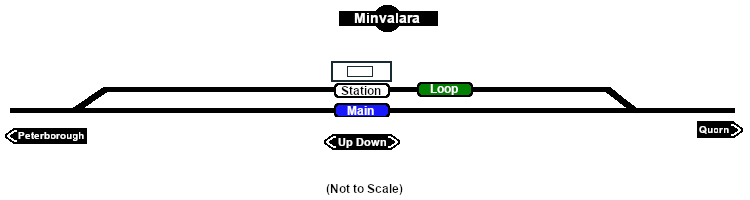
| − | <table width=750> <!-- BEGIN Switch Sets Station/Loop table --> | + | Unmanned station on the <span style="font-weight: 700; color: white; background-color: black;"> Peterborough-Quorn Line </span>.<br> |
| − | <tr valign="top"> | + | |
| | | | |
| − | <td width=200><span style="font-weight: 700;"><span style="background-color: black; color: white;"> Peterborough - </span><span style="background-color: white; color: black;"> Station </span> <span style="background-color: #008100; color: white;"> Loop </span></span></td>
| + | Station and crossing loop.<br> |
| | | | |
| − | <td width=175><span style="font-weight: 700;"><span style="background-color: black; color: yellow;"> 1 </span>-L <span style="background-color: red; color: white;"> A </span>-L </span></td> | + | Prior to 1956 when the narrow gauge line from '''Port Augusta''' to '''Maree''' was closed, '''Minvalara''' was used by loaded '''Leigh Creek''' coal trains to prepare their fires for the long climb up to '''Peterborough'''.<br> |
| | | | |
| − | <td width=200><span style="font-weight: 700;"><span style="background-color: black; color: white;"> Quorn - </span><span style="background-color: white; color: black;"> Station </span> <span style="background-color: #008100; color: white;"> Loop </span></span></td> | + | '''Minvalara''' was no longer in use after 1970 and had been removed from the working timetable by 1982. The line from '''Peterborough''' to '''Eurelia''' was closed to normal traffic in 1988 and was fully closed in 2002. Most of the track was removed in 2008.<br> |
| − | | + | |
| − | <td width=175><span style="font-weight: 700;"><span style="background-color: black; color: yellow;"> 2 </span>-R <span style="background-color: red; color: white;"> B </span>-R </span></td>
| + | |
| | | | |
| | + | Today the only indication that '''Minvalara''' was once a railway location is the remains of part of the platform. |
| | + | </td> |
| | </tr> | | </tr> |
| − | </table> <!-- END Switch Sets Station/Loop table -->
| |
| | | | |
| − | <table width=750> <!-- BEGIN Switch Mainline table -->
| |
| | <tr valign="top"> | | <tr valign="top"> |
| − | | + | <td align="center">[[Image:line740.png|link=]]</td> |
| − | <td width=200><span style="font-weight: 700;"><span style="background-color: black; color: white;"> Peterborough - </span><span style="background-color: #1919fe; color: white;"> Main </span></span></td> | + | |
| − | | + | |
| − | <td width=175><span style="font-weight: 700;"><span style="background-color: black; color: yellow;"> 1 </span>-R </span></td>
| + | |
| − | | + | |
| − | <td width=200><span style="font-weight: 700;"><span style="background-color: black; color: white;"> Quorn - </span><span style="background-color: #1919fe; color: white;"> Main </span></span></td>
| + | |
| − | | + | |
| − | <td width=175><span style="font-weight: 700;"><span style="background-color: black; color: yellow;"> 2 </span>-L </span></td>
| + | |
| − | | + | |
| | </tr> | | </tr> |
| − | </table> <!-- END Switch Sets Mainline table -->
| |
| | | | |
| − | </tr>
| + | </table> <!-- END Information Table --> |
| − | <tr valign="top">
| + | |
| − | <td colspan=6 align="center">[[Image:line740.png|link=]]</td>
| + | |
| − | </tr>
| + | |
| − | | + | |
| − | </table> <!-- END Paths Table --> | + | |
| − | <table width=750> <!-- BEGIN end Links -->
| + | |
| − | <tr valign="top">
| + | |
| − | <td width=450> </td>
| + | |
| − | <td align="right" width=300>[[image:ToTracksUp.png|link=#TrackData]] [[file:BackToTop.png|link=#top]]</td>
| + | |
| − | </tr>
| + | |
| − | </table> <!-- END end Links -->
| + | |
| | | | |
| | </td> | | </td> |
| | <td> | | <td> |
| | + | [[Image:SAR_Peterborough-Quorn_Line.png|link=SAR_Peterborough-Quorn|alt=Peterborough-Quorn|Show Peterborough-Quorn]]<br> |
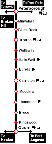
| | [[Image:SAR_Peterborough-Quorn Strip Map.png|link=|alt=Peterborough-Quorn Strip Map]]</td> | | [[Image:SAR_Peterborough-Quorn Strip Map.png|link=|alt=Peterborough-Quorn Strip Map]]</td> |
| | </tr> | | </tr> |
| − | </table> <!-- END TOP TABLE --> | + | </table> <!-- END TOP TABLE --> |
| − | {{Anchor|BaseData}}
| + | |