SAR Booleroo Centre V1
(Created page with "<!-- V1.0 --> <table> <tr valign="top"> <td width=750> <table width=750> <tr valign="top"> <td align="center">link=</td> </tr> <tr valign="top"> <td ali...") |
|||
| Line 29: | Line 29: | ||
<table width=750> | <table width=750> | ||
<tr valign="top"> | <tr valign="top"> | ||
| − | <td>[[image: | + | <td>[[image:SAR_Booleroo_V1.png|link=|alt=Booleroo Centre map]]</td> |
| + | </tr> | ||
| + | <tr valign="top"> | ||
| + | <td align="center"><span style="font-weight: 700;">Map and description for the original <span style="color: blue;">SAR Peterborough Narrow Gauge Division (v1.0)</span> version. For the latest updated <span style="color: blue;">V2.0</span> version click <span style="background-color: yellow;">[[SAR_Booleroo_Centre|here]]</span></span><br> | ||
| + | [[Image:line740.png|link=]]</td> | ||
</tr> | </tr> | ||
</table> | </table> | ||
| Line 96: | Line 100: | ||
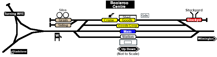
Passenger services ended in 1969. The line was closed in 1990 and the track has since been removed.<br> | Passenger services ended in 1969. The line was closed in 1990 and the track has since been removed.<br> | ||
| − | Today the grain facilities are still present. A variety of items, including a station nameboard, water column, goods crane and a switchstand, have been preserved in the yard as part of an interpretive display.<br> | + | Today the grain facilities are still present. A variety of infrastructure items, including a station nameboard, water column, goods crane and a switchstand, have been preserved in the yard as part of an interpretive display.<br> |
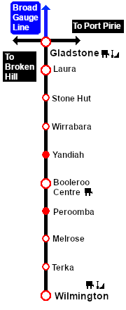
| − | The former right-of-way from ''' | + | The former right-of-way from just south of '''Laura''' to '''Wilmington''' is now an 80km walking, cycling and horse riding trail, the '''[https://www.railtrails.org.au/trails/southern-flinders-rail-trail/ Southern Flinders Rail Trail]'''. |
</td> | </td> | ||
</tr> | </tr> | ||
Latest revision as of 14:59, 3 April 2024
|
|
