|
|
| (10 intermediate revisions by one user not shown) |
| Line 1: |
Line 1: |
| − | <!-- V1.0 and V2.0 versions --> | + | <!-- V1.0 --> |
| − | <!-- V2.0 has additional grain silos and a water tower, goods shed and crane moved to station track -->
| + | |
| − | <!-- BEGIN V1.0 -->
| + | |
| | <table> | | <table> |
| | <tr valign="top"> | | <tr valign="top"> |
| Line 90: |
Line 88: |
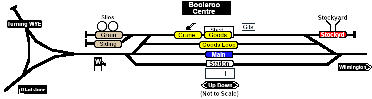
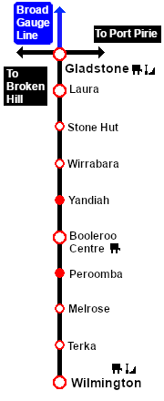
| | A manned station on the <span style="font-weight: 700; color: white; background-color: black;"> Gladstone-Wilmington Line </span> until 1983 when all the station staff on the line were withdrawn.<br> | | A manned station on the <span style="font-weight: 700; color: white; background-color: black;"> Gladstone-Wilmington Line </span> until 1983 when all the station staff on the line were withdrawn.<br> |
| | | | |
| − | A station and goods loop. Two grain loading facilities, storage sheds for bagged grain and grain sidings. A stockyard siding. Loco watering facilities and a turning WYE. An engine shed was present on the '''WYE''' until 1915.<br> | + | A station and goods loop, grain loading facility, storage sheds for bagged grain and grain sidings. A stockyard siding. Loco watering facilities and a turning WYE. An engine shed was present on the '''WYE''' until 1915.<br> |
| | | | |
| | The '''Gladstone-Wilmington Line''' is '''unsignalled'''. Train Order working is in operation on the line.<br> | | The '''Gladstone-Wilmington Line''' is '''unsignalled'''. Train Order working is in operation on the line.<br> |
| Line 98: |
Line 96: |
| | Passenger services ended in 1969. The line was closed in 1990 and the track has since been removed.<br> | | Passenger services ended in 1969. The line was closed in 1990 and the track has since been removed.<br> |
| | | | |
| − | A variety of items, including a station nameboard, water column, goods crane and a switchstand, have been preserved in the yard as part of an interpretive display. | + | Today the grain facilities are still present. A variety of items, including a station nameboard, water column, goods crane and a switchstand, have been preserved in the yard as part of an interpretive display.<br> |
| − | </td>
| + | |
| − | </tr> | + | |
| | | | |
| − | <tr valign="top">
| + | The former right-of-way from just south of '''Laura''' to '''Wilmington''' is now an 80km walking, cycling and horse riding trail, the '''[https://www.railtrails.org.au/trails/southern-flinders-rail-trail/ Southern Flinders Rail Trail]'''. |
| − | <td align="center">[[Image:line740.png|link=]]</td>
| + | |
| − | </tr>
| + | |
| − | | + | |
| − | </table>
| + | |
| − | | + | |
| − | </td>
| + | |
| − | <td>
| + | |
| − | [[Image:SAR_Gladstone-Wilmington_Line.png|link=SAR_Gladstone_Wilmington|alt=Gladstone-Wilmington|Show Gladstone-Wilmington]]<br>
| + | |
| − | [[Image:SAR_Gladstone-Wilmington Strip Map.png|link=|alt=Gladstone-Wilmington Strip Map]]
| + | |
| − | </td>
| + | |
| − | </tr>
| + | |
| − | </table>
| + | |
| − | | + | |
| − | <!-- END V1.0 -->
| + | |
| − | <!-- BEGIN V2.0
| + | |
| − | <table>
| + | |
| − | <tr valign="top">
| + | |
| − | <td width=750>
| + | |
| − | | + | |
| − | <table width=750>
| + | |
| − | <tr valign="top">
| + | |
| − | <td align="center">[[Image:line740.png|link=]]</td>
| + | |
| − | </tr>
| + | |
| − | <tr valign="top">
| + | |
| − | <td align="center">[[image:Tab_HM_White.png|link=]] [[image:Tab_IN_Grey.png|link=SAR_Booleroo_Centre_Industry]] [[image:Tab_TM_Grey.png|link=SAR_Booleroo_Centre_TrackMarks]] [[image:Tab_SW_Grey.png|link=SAR_Booleroo_Centre_Switches]] [[image:Tab_Blank_Grey.png|link=]]</td>
| + | |
| − | </tr>
| + | |
| − | <tr valign="top">
| + | |
| − | <td align="center">[[Image:line740.png|link=]]</td>
| + | |
| − | </tr>
| + | |
| − | </table>
| + | |
| − | <table bgcolor="lightgrey" bordercolor="lightgrey" width=750>
| + | |
| − | | + | |
| − | <tr valign="middle">
| + | |
| − | <td width=220 align="right">[[Image:SAR_Gladstone-Wilmington_Line.png|link=SAR Gladstone-Wilmington|alt=Gladstone-Wilmington|Show Gladstone-Wilmington]]</td>
| + | |
| − | <td width=110 align="center">[[Image:Next Left.png|link=|alt=]]<br>[[Image:SAR_Yandiah_Name.png|link=SAR Yandiah|alt=Yandiah|Next Up Location]]</td>
| + | |
| − | <td width=90 align="center">[[Image:Location Index.png|link=SAR Index|alt=Location Index|Location Index]]<br>[[image:Scenario Index.png|link=SAR Peterborough Base Session|alt=Scenarios|Scenario Index]]</td>
| + | |
| − | <td width=110 align="left">[[Image:Next Right.png|link=|alt=]]<br>[[Image:SAR_Peroomba_Name.png|link=SAR Peroomba||alt=Peroomba|Next Down Location]]</td>
| + | |
| − | <td width=220 align="left">[[Image:SAR_Gladstone-Wilmington_Line.png|link=SAR Gladstone-Wilmington|alt=Gladstone-Wilmington|Show Gladstone-Wilmington]]</td>
| + | |
| − | </tr>
| + | |
| − | | + | |
| − | </table>
| + | |
| − | | + | |
| − | <table width=750>
| + | |
| − | <tr valign="top">
| + | |
| − | <td>[[image:SAR_Booleroo_Centre.png|link=|alt=Booleroo_Centre map]]</td>
| + | |
| − | </tr>
| + | |
| − | <tr valign="top">
| + | |
| − | <td align="center"><span style="font-weight: 700;">Map and loco services updated for <span style="color: blue;">SAR Peterborough Narrow Gauge Division v2.0</span></span><br>
| + | |
| − | [[Image:line740.png|link=]]</td>
| + | |
| − | </tr>
| + | |
| − | </table>
| + | |
| − | | + | |
| − | <table bgcolor="lightgrey" bordercolor="lightgrey" width=750>
| + | |
| − | | + | |
| − | <tr valign="top">
| + | |
| − | <td><span style="font-weight: 700; background-color: black; color: white;"> Commodities: </span>
| + | |
| − | | + | |
| − | <table width=300>
| + | |
| − | <tr valign="top">
| + | |
| − | | + | |
| − | <td align="center" width=50>[[Image:Passenger_Icon_off.png|link=|alt=Passengers]]<br><span style="font-size: 10px; font-weight: 700;">Passengers</span><br>[[image:Station_Label.png|link=]]</td>
| + | |
| − | <td align="center" width=50>[[Image:Goods_Icon.png|link=|alt=Goods]]<br><span style="font-size: 10px; font-weight: 700;">Goods</span><br>[[image:Goods_Label.png|link=]]</td>
| + | |
| − | <td align="center" width=50>
| + | |
| − | <table bgcolor="blue" width=50>
| + | |
| − | <tr valign="top">
| + | |
| − | <td>
| + | |
| − | <table bgcolor="lightgrey">
| + | |
| − | <tr valign="top">
| + | |
| − | <td>[[Image:Grain_Icon.png|link=|alt=Grain]]<br><span style="font-size: 10px; font-weight: 700;">Grain</span><br>[[image:Grain_Label.png|link=]]</td>
| + | |
| − | </tr>
| + | |
| − | </table>
| + | |
| − | </td>
| + | |
| − | </tr>
| + | |
| − | </table>
| + | |
| − | </td>
| + | |
| − | <td align="center" width=50>[[Image:Livestock_Icon.png|link=|alt=Livestock]]<br><span style="font-size: 10px; font-weight: 700;">Livestock</span><br>[[image:Stockyard_Label.png|link=]]</td>
| + | |
| − | <td align="center" width=50> </td>
| + | |
| − | | + | |
| − | </tr>
| + | |
| − | </table>
| + | |
| − | | + | |
| − | </td>
| + | |
| − | <td style="background-color: black;"><span style="color: white; font-weight: 700;"> Loco Services: </span>
| + | |
| − | | + | |
| − | <table width=175>
| + | |
| − | <tr valign="top">
| + | |
| − | | + | |
| − | <td align="center" width=50>
| + | |
| − | <table bgcolor="blue" width=50>
| + | |
| − | <tr valign="top">
| + | |
| − | <td>
| + | |
| − | <table bgcolor="black">
| + | |
| − | <tr valign="top">
| + | |
| − | <td>[[Image:Water_Icon.png|link=|alt=Water]]<br><span style="font-size: 10px; color: white; font-weight: 700;">Water</span><br>[[image:Main_Label.png|link=]]<br>[[image:Grain_Label.png|link=]]</td>
| + | |
| − | </tr>
| + | |
| − | </table>
| + | |
| − | </td>
| + | |
| − | </tr>
| + | |
| − | </table>
| + | |
| − | </td>
| + | |
| − | <td align="center" width=50> </td>
| + | |
| − | <td align="center" width=50> </td>
| + | |
| − | | + | |
| − | </tr>
| + | |
| − | </table>
| + | |
| − | | + | |
| − | </td>
| + | |
| − | <td><span style="font-weight: 700;"><span style="background-color: black; color: white;"> Facilities: </span></span>
| + | |
| − | | + | |
| − | <table width=250>
| + | |
| − | <tr valign="top">
| + | |
| − | | + | |
| − | <td align="center" width=50>[[Image:WYE_Icon.png|link=|alt=WYE]]<br><span style="font-size: 10px; font-weight: 700;">Turning</span><br>[[image:WYE_Label.png|link=]]</td>
| + | |
| − | <td align="center" width=50> </td>
| + | |
| − | <td align="center" width=50> </td>
| + | |
| − | <td align="center" width=50> </td>
| + | |
| − | | + | |
| − | </tr>
| + | |
| − | </table>
| + | |
| − | | + | |
| − | </td>
| + | |
| − | </tr>
| + | |
| − | </table>
| + | |
| − | | + | |
| − | <table width=750>
| + | |
| − | <tr valign="top">
| + | |
| − | <td>
| + | |
| − | <span style="font-weight: 700;"><span style="color: white; background-color: black;"> Distance from Gladstone: </span> 50¾ kms, 31½ miles</span><br>
| + | |
| − | | + | |
| − | A manned station on the <span style="font-weight: 700; color: white; background-color: black;"> Gladstone-Wilmington Line </span> until 1983 when all the station staff on the line were withdrawn.<br>
| + | |
| − | | + | |
| − | A station and goods loop. Two grain loading facilities, storage sheds for bagged grain and grain sidings. A stockyard siding. Loco watering facilities and a turning WYE. An engine shed was present on the '''WYE''' until 1915.<br>
| + | |
| − | | + | |
| − | The '''Gladstone-Wilmington Line''' is '''unsignalled'''. Train Order working is in operation on the line.<br>
| + | |
| − | | + | |
| − | '''Booleroo Centre''' was the terminus of the line from 1910 to 1915 which explains the presence of the turning WYE. It was also the busiest station on the line with both terminating and through freight services.<br> | + | |
| − | | + | |
| − | Passenger services ended in 1969. The line was closed in 1990 and the track has since been removed.<br>
| + | |
| − | | + | |
| − | A variety of items, including a station nameboard, water column, goods crane and a switchstand, have been preserved in the yard as part of an interpretive display.
| + | |
| | </td> | | </td> |
| | </tr> | | </tr> |
| Line 259: |
Line 115: |
| | </tr> | | </tr> |
| | </table> | | </table> |
| − |
| |
| − | END V2.0 -->
| |