SAR Halls Well V1

From TrainzOnline
Revision as of 16:21, 29 April 2024 by Pware (Talk | contribs)

Jump to: navigation, search
Line740.png
Tab HM White.png Tab IN Grey.png Tab TM Grey.png Tab Blank Grey.png Tab Blank Grey.png
Line740.png
Peterborough-Quorn Line
Wallaway
Location Index
Scenarios

Eurelia
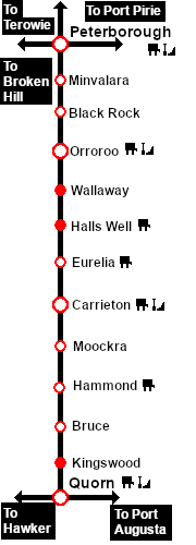
Peterborough-Quorn Line
Halls Well map
This is the original v1.0 Halls Well Map and description. For the latest SAR Peterborough Narrow Gauge Division v2.0 version click here. The V2.0 version of the route and sessions requires Trainz Plus or TRS22
Line740.png
 
 Loco Services: 
Water
Water
Main Label.png


 Distance from Peterborough:  51½ kms, 32 miles

Unmanned location on the  Peterborough-Quorn Line .

A water tower on the main line. No sidings or loops.

The tank was filled with water from a well which was purchased from a Mr Hall in 1897 (hence the name Halls Well) and was notable as being the only source of underground water used by the SAR. It was mostly used as a "top-up" for freight trains making the long climb from Orroroo to Eurelia which has some of the steepest grades on the line.

Line740.png

Peterborough-Quorn

Peterborough-Quorn Strip Map
Personal tools