File:SAR Gladstone-Paratoo Strip Map V2.png
From TrainzOnline
(Difference between revisions)
(V2 of the Gladstone-Paratoo Strip map (includes Peterborough West)) |
(Pware uploaded a new version of "File:SAR Gladstone-Paratoo Strip Map V2.png": Update - height reduced) |
Latest revision as of 22:53, 13 June 2024
V2 of the Gladstone-Paratoo Strip map (includes Peterborough West)
File history
Click on a date/time to view the file as it appeared at that time.
| Date/Time | Thumbnail | Dimensions | User | Comment | |
|---|---|---|---|---|---|
| current | 22:53, 13 June 2024 | 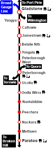 | 180 × 430 (20 KB) | Pware (Talk | contribs) | Update - height reduced |
| 14:34, 25 April 2024 | 180 × 500 (20 KB) | Pware (Talk | contribs) | V2 of the Gladstone-Paratoo Strip map (includes Peterborough West) |
- Edit this file using an external application (See the [//www.mediawiki.org/wiki/Manual:External_editors setup instructions] for more information)
File usage
The following 61 pages link to this file:
- SAR Belalie North Industry V2
- SAR Belalie North Switches V2
- SAR Belalie North TrackMarks V2
- SAR Belalie North V2
- SAR Caltowie Industry V2
- SAR Caltowie Switches V2
- SAR Caltowie TrackMarks V2
- SAR Caltowie V2
- SAR Gladstone Industry V2
- SAR Gladstone Switches V2
- SAR Gladstone TrackMarks V2
- SAR Gladstone V2
- SAR Jamestown Industry V2
- SAR Jamestown Switches V2
- SAR Jamestown TrackMarks V2
- SAR Jamestown V2
- SAR Methuen Switches V2
- SAR Methuen TrackMarks V2
- SAR Methuen V2
- SAR Nackara Industry V2
- SAR Nackara Switches V2
- SAR Nackara TrackMarks V2
- SAR Nackara V2
- SAR Nantabibbie Switches V2
- SAR Nantabibbie TrackMarks V2
- SAR Nantabibbie V2
- SAR Oodla Wirra Industry V2
- SAR Oodla Wirra Switches V2
- SAR Oodla Wirra TrackMarks V2
- SAR Paratoo Industry V2
- SAR Paratoo Switches V2
- SAR Paratoo TrackMark V2
- SAR Paratoo TrackMarks V2
- SAR Paratoo V2
- SAR Peechara Switches V2
- SAR Peechara TRackMarks V2
- SAR Peechara TrackMarks V2
- SAR Peechara V2
- SAR Peterborough Industry V2
- SAR Peterborough Switches V2
- SAR Peterborough TrackMarks V2
- SAR Peterborough V2
- SAR Peterborough West Industry V2
- SAR Peterborough West TrackMarks V2
- SAR Peterborough West V2
- SAR Scenario Gladstone Bulk Ore V2
- SAR Scenario Paratoo Empty Ore V2
- SAR Scenario Transcontinental Express Freight V2
- SAR Ucolta Industry V2
- SAR Ucolta Switches V2
- SAR Ucolta TrackMarks V2
- SAR Ucolta V2
- SAR Yangya Industry V2
- SAR Yangya Switches V2
- SAR Yangya TM V2
- SAR Yangya TrackMarks V2
- SAR Yangya V2
- SAR Yongala Industry V2
- SAR Yongala Switches V2
- SAR Yongala TrackMarks V2
- SAR Yongala V2