 |
| For SAR Peterborough Narrow Gauge Division v2.0. For the original V1.0 click here |
 |
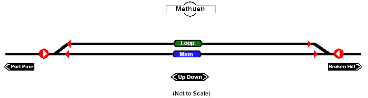
| Track Marks |
| Destinations for "Drive Via Trackmark NAME " or "Drive To Trackmark NAME " AI commands. The direction that a track mark points has no effect on its operation. The direction that a track mark points has no effect on its operation. |
|
| Approach from Port Pirie |
|
 Methuen Main Approach Dn Methuen Main Approach Dn |
| Approach from Broken Hill |
 Methuen Main Approach Up Methuen Main Approach Up |
 |
 Methuen Main Up Methuen Main Up |
 Methuen Main Dn Methuen Main Dn |
 |
Methuen Loop Up |
Methuen Loop Dn |
|
|
 |
