From TrainzOnline
(Difference between revisions)
|
|
| (One intermediate revision by one user not shown) |
| Line 33: |
Line 33: |
| | </tr> | | </tr> |
| | <tr valign="top"> | | <tr valign="top"> |
| − | <td align="center"><span style="font-weight: 700;">This is the original <span style="color: blue;">v1.0 Nantabibbie Map and description</span>. For the latest <span style="color: blue;">SAR Peterborough Narrow Gauge Division v2.0</span> version click <span style="background-color: yellow;">[[SAR_Nantabibbie_V2|here]]</span></span>. The '''v2.0''' version of the route and sessions requires '''Trainz Plus''' or '''TRS22'''<br> | + | <td align="center"><span style="font-weight: 700;">For <span style="color: blue;">SAR Peterborough Narrow Gauge Division v1.0</span>. For the latest <span style="color: blue;">V2.0</span> click <span style="background-color: yellow;">[[SAR_Nantabibbie_V2|here]]</span></span></td> |
| − | [[Image:line740.png|link=]]</td> | + | </tr> |
| | + | </table> |
| | + | |
| | + | <table width=750> |
| | + | <tr valign="top"> |
| | + | <td align="center">[[Image:line740.png|link=]]</td> |
| | </tr> | | </tr> |
| | </table> | | </table> |
Latest revision as of 10:18, 1 May 2024
 |
| For SAR Peterborough Narrow Gauge Division v1.0. For the latest V2.0 click here |
|
|
|
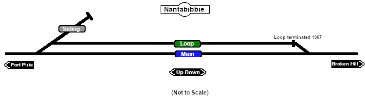
Facilities:

Loop
 |
|
|
|
|
|
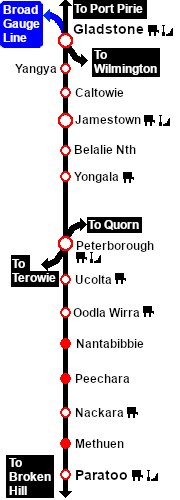
Distance from Peterborough: 34 kms, 21¼ miles
Unmanned location on the Port Pirie-Broken Hill Line .
A short crossing loop (not suitable for long trains) and a works siding. The loop had been converted to a dead end siding by 1967.
This location was bypassed when the line was converted to standard gauge (4ft8½in - 1435mm) during 1969-1970.
|
 |
|

 |
