SAR Caltowie V1

From TrainzOnline
Jump to: navigation, search
Line740.png
Tab HM White.png Tab IN Grey.png Tab TM Grey.png Tab SW Grey.png Tab Blank Grey.png
Line740.png
PortPirie-BrokenHill
Gladstone
Location Index
Scenarios

Caltowie
PortPirie-BrokenHill
Caltowie map
This is the original v1.0 Caltowie Map and description. For the latest SAR Peterborough Narrow Gauge Division v2.0 version click here. The v2.0 version of the route and sessions requires Trainz Plus or TRS22
Line740.png
 Commodities: 
Passengers
Passengers
Station Label.png
Goods
Goods
Goods Label.png
Grain
Grain
Grain Label.png
   
 
 Facilities: 
Loop
Loop
Loop Label.png
     

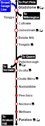
 Distance from Gladstone:  18 kms, 11½ miles  from Peterborough:  47½ kms, 29½ miles

Manned station on the  Port Pirie-Broken Hill Line .

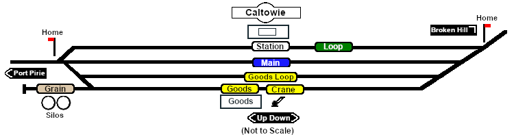
Station loop, goods and grain loop, a goods loop, and a grain storage siding.

After the conversion of the line to standard gauge (4ft8½in - 1434mm) in 1969-70 Caltowie became just a crossing loop and a grain terminal. There are no passenger services.

Line740.png

PortPirie-BrokenHill

Gladstone-Paratoo Strip Map
Personal tools