SAR Yongala V2
From TrainzOnline
(Difference between revisions)
(Created page with "<!-- V2.0 (seperate V1.0 file) --> <table> <tr valign="top"> <td width=750> <table width=750> <tr valign="top"> <td align="center">link=</td> </tr> <tr ...") |
m |
||
| Line 9: | Line 9: | ||
</tr> | </tr> | ||
<tr valign="top"> | <tr valign="top"> | ||
| − | <td align="center">[[image:Tab_HM_White.png|link=]] [[image:Tab_IN_Grey.png|link= | + | <td align="center">[[image:Tab_HM_White.png|link=]] [[image:Tab_IN_Grey.png|link=SAR_Yongala_Industry_V2]] [[image:Tab_TM_Grey.png|link=SAR_Yongala_TrackMarks_V2]] [[image:Tab_SW_Grey.png|link=SAR_Yongala_Switches_V2]] [[image:Tab_Blank_Grey.png|link=]]</td> |
</tr> | </tr> | ||
<tr valign="top"> | <tr valign="top"> | ||
| Line 18: | Line 18: | ||
<table bgcolor="lightgrey" bordercolor="lightgrey" width=750> | <table bgcolor="lightgrey" bordercolor="lightgrey" width=750> | ||
<tr valign="middle"> | <tr valign="middle"> | ||
| − | <td width=220 align="right">[[Image:SAR_PortPirie-BrokenHill_Line.png|link=SAR_Port_Pirie- | + | <td width=220 align="right">[[Image:SAR_PortPirie-BrokenHill_Line.png|link=SAR_Port_Pirie-Broken_Hill_V2|alt=PortPirie-BrokenHill|Show Port Pirie-Broken Hill]]</td> |
| − | <td width=110 align="center">[[Image:Next Left.png|link=|alt=]]<br>[[Image:SAR_Belalie_North_Name.png|link=SAR Belalie | + | <td width=110 align="center">[[Image:Next Left.png|link=|alt=]]<br>[[Image:SAR_Belalie_North_Name.png|link=SAR Belalie North_V2|alt=Belalie North|Next Up Location]]</td> |
| − | <td width=90 align="center">[[Image:Location Index.png|link=SAR | + | <td width=90 align="center">[[Image:Location Index.png|link=SAR Index_V2|alt=Location Index|Location Index]]<br>[[image:Scenario Index.png|link=SAR Peterborough Base Session_V2|alt=Scenarios]]</td> |
| − | <td width=110 align="center">[[Image:Next Right.png|link=|alt=]]<br>[[Image:SAR_Peterborough_West_Name.png|link=SAR | + | <td width=110 align="center">[[Image:Next Right.png|link=|alt=]]<br>[[Image:SAR_Peterborough_West_Name.png|link=SAR Peterborough_West_V2|alt=Peterborough West|Next Down Location]]</td> |
| − | <td width=220 align="left">[[Image:SAR_PortPirie-BrokenHill_Line.png|link=SAR_Port_Pirie- | + | <td width=220 align="left">[[Image:SAR_PortPirie-BrokenHill_Line.png|link=SAR_Port_Pirie-Broken_Hill_V2|alt=PortPirie-BrokenHill|Show Port Pirie-Broken Hill]]</td> |
</tr> | </tr> | ||
</table> | </table> | ||
| Line 28: | Line 28: | ||
<table width=750> | <table width=750> | ||
<tr valign="top"> | <tr valign="top"> | ||
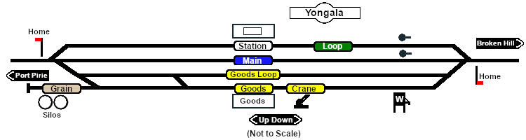
| − | <td>[[image: | + | <td>[[image:SAR_Yongala.png|link=|alt=Yongala map]]</td> |
</tr> | </tr> | ||
<tr valign="top"> | <tr valign="top"> | ||
| − | <td align="center"><span style="font-weight: 700;"> | + | <td align="center"><span style="font-weight: 700;">Links updated for <span style="color: blue;">SAR Peterborough Narrow Gauge Division v2.0</span>. For the original <span style="color: blue;">V1.0</span> version click <span style="background-color: yellow;">[[SAR_Yongala_V1|here]]</span></span><br> |
[[Image:line740.png|link=]]</td> | [[Image:line740.png|link=]]</td> | ||
</tr> | </tr> | ||
| Line 103: | Line 103: | ||
</td> | </td> | ||
<td> | <td> | ||
| − | [[Image:SAR_PortPirie-BrokenHill_Line.png|link=SAR_Port_Pirie- | + | [[Image:SAR_PortPirie-BrokenHill_Line.png|link=SAR_Port_Pirie-Broken_Hill_V2|alt=PortPirie-BrokenHill|Show Port Pirie-Broken Hill]]<br> |
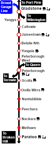
| − | [[Image:SAR_Gladstone-Paratoo Strip | + | [[Image:SAR_Gladstone-Paratoo Strip Map_V2.png|link=|alt=Gladstone-Paratoo Strip Map]]</td> |
</tr> | </tr> | ||
</table> | </table> | ||
Revision as of 22:49, 27 April 2024
|
 |
