SAR Belalie North V2

From TrainzOnline
Jump to: navigation, search
Line740.png
Tab HM White.png Tab IN Grey.png Tab TM Grey.png Tab SW Grey.png Tab Blank Grey.png
Line740.png
PortPirie-BrokenHill
Jamestown
Location Index
Scenarios

Yongala
PortPirie-BrokenHill
Belalie North map
For SAR Peterborough Narrow Gauge Division v2.0. For the original V1.0 click here
Line740.png
 Commodities: 
Passengers
Passengers
Station Label.png
Goods
Goods
Goods Label.png
Livestock
Livestock
Stockyard Label.png
   
 
 Facilities: 
Loop
Loop
Loop Label.png
     

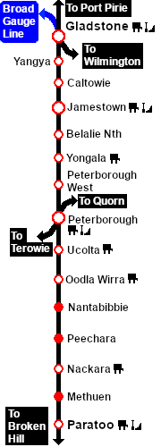
 Distance from Gladstone:  43½ kms, 27 miles  from Peterborough:  20½ kms, 12¾ miles

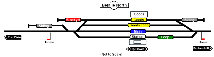
Unmanned station on the  Port Pirie-Broken Hill Line . At 621m (2,037ft) Belalie North was the highest point in the entire SAR system.

Station, goods and crossing loops with a stockyard and storage sidings.

This location was bypassed in favour of an alignment with easier grades when the line was converted to standard gauge (4ft8½in - 1435mm) during 1969-1970.

Line740.png

PortPirie-BrokenHill

Gladstone-Paratoo Strip Map
Personal tools