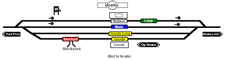
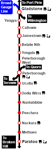
SAR Ucolta V2

From TrainzOnline
(Difference between revisions)
Jump to: navigation, search
m
m
Line 31: Line 31:
 
</tr>
 
</tr>
 
<tr valign="top">
 
<tr valign="top">
<td align="center"><span style="font-weight: 700;">Updated for <span style="color: blue;">SAR Peterborough Narrow Gauge Division v2.0</span>. For the original <span style="color: blue;">V1.0</span> version click <span style="background-color: yellow;">[[SAR_Ucolta_V1|here]]</span></span><br>
+
<td align="center"><span style="font-weight: 700;">Links updated for <span style="color: blue;">SAR Peterborough Narrow Gauge Division v2.0</span>. For the original <span style="color: blue;">V1.0</span> version click <span style="background-color: yellow;">[[SAR_Ucolta_V1|here]]</span></span><br>
 
[[Image:line740.png|link=]]</td>
 
[[Image:line740.png|link=]]</td>
 
</tr>
 
</tr>

Revision as of 08:31, 28 April 2024

Line740.png
Tab HM White.png Tab IN Grey.png Tab TM Grey.png Tab SW Grey.png Tab Blank Grey.png
Line740.png
PortPirie-BrokenHill
Belalie North
Location Index
Scenarios

Peterborough West
PortPirie-BrokenHill
Ucolta map
Links updated for SAR Peterborough Narrow Gauge Division v2.0. For the original V1.0 version click here
Line740.png
 Commodities: 
Passengers
Passengers
Station Label.png
Goods
Goods
Goods Label.png
Livestock
Livestock
Stockyard Label.png
   
 Loco Services: 
Water
Water
Main Label.png
Loop Label.png
   
 Facilities: 
Loop
Loop
Loop Label.png
     

 Distance from Peterborough:  13¼ kms, 8¼ miles
Unmanned station on the  Port Pirie-Broken Hill Line .

Crossing, station and goods/stockyard loops with loco watering facilities.

After the conversion of the line to standard gauge (1969-70) Ucolta became just a crossing loop with a single goods siding. More recently, the loop and siding have been removed. The station is no longer in use.

Line740.png

PortPirie-BrokenHill

Gladstone-Paratoo Strip Map
Personal tools