SAR Changes Log
| SAR Peterborough Narrow Gauge Division |
| Changes Between Version 1.0 and Version 2.0 |
| Version 1.0 of the route and base session were created for TRS19 (SP3) and above. Version 2.0 of the route and base session were created for TRS22 (SP3) and Trainz Plus and above. Most of the changes made to the maps, industries, switches and track marks between the two versions are due to more up to date historical information becoming available. I recently gained access to a vast online archive of historical photographs and documents covering all Australian railways. As a result I have noted, in most cases, minor differences and, in a few cases, major differences between the details revealed in the archive and the original published material on which the Peterborough Division route was based. Those location where differences were discovered have been updated in Version 2.0 of the route, session and scenarios. |
![]()
Port Pirie to Broken Hill Line
|
 |
||||||||||||||||||||||||||||||||||||||||||||||||||||||||
![]()
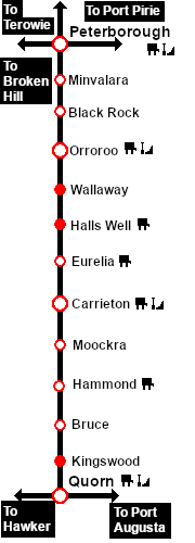
Peterborough to Quorn Line
|
 |
||||||||||||||||||||||
![]()
Gladstone to Wilmington Line
| Wirrabara: | |
| Stockyard added on a siding | |
| Yandiah: | |
| Stockyard added on a siding | |
| Passenger Halt track mark added to main line | |
| Booleroo Centre: | |
| A large grain terminal has been added to the end of the WYE with new track marks | |
| The goods facilities have been moved to the station road (as shown in photographs) leaving the former goods yard road as a grain yard road | |
| The water tower has been moved from the down approach to the yard area | |
| Water columns have been added to some of the running yard roads, each has a track mark | |
| A turnout has been added between the station yard road and the main yard road | |
| Peroomba: | |
| A passenger shelter has been added to the loop with track marks | |
| Melrose: | |
| A grain silo has been added to a siding | |
| A goods crane has added to the goods road | |
| Wilmington: | |
| A stockyard has been added on the WYE | |
![]()
Base Session
More rolling stock has been added.
![]()
Scenarios
Original V1.0 Scenarios:
| Most of these have been updated to take advantage of the changes that have been made to many of the location in the route. Where changes have been made and an updated V2.0 version has been created, a link has been provided to the original V1.0 version. Most of the scenarios have been provided with a sample timetable for one or several trains that could be run. |
New V2.0 Scenarios:
| The new V2.0 scenarios make use of additional rolling stock that has been added to the SAR Peterborough Division Base Session V2.0 and the additional trackage from Woolshed Flats to Hawker. Most have also been provided with a sample timetable for one or several trains that could be run. |
![]()