SAR Summit
From TrainzOnline
(Difference between revisions)
(Created page with "<table> <!-- BEGIN TOP TABLE --> <tr valign="top"> <td width=750> <table width=750> <!-- BEGIN TABBED link list with Home page active--> <tr valign="top"> <td align="center...") |
m |
||
| (8 intermediate revisions by one user not shown) | |||
| Line 8: | Line 8: | ||
</tr> | </tr> | ||
<tr valign="top"> | <tr valign="top"> | ||
| − | <td align="center">[[image:Tab_HM_White.png|link=]] [[image:Tab_Blank_Grey.png|link=]] [[image:Tab_TM_Grey.png|link= | + | <td align="center">[[image:Tab_HM_White.png|link=]] [[image:Tab_Blank_Grey.png|link=]] [[image:Tab_TM_Grey.png|link=SAR_Summit_Trackmarks]] [[image:Tab_SW_Grey.png|link=SAR_Summit_Switches]] [[image:Tab_Blank_Grey.png|link=]]</td> |
</tr> | </tr> | ||
<tr valign="top"> | <tr valign="top"> | ||
| Line 18: | Line 18: | ||
<tr valign="middle"> | <tr valign="middle"> | ||
| − | <td width=220 align=" | + | <td width=220 align="center">[[Image:SAR_PortAugusta-Hawker_Line.png|link=SAR_Port_Augusta-Hawker|alt=Port Augusta-Hawker|Show Port Augusta-Hawker]]</td> |
| − | + | <td width=110 align="right">[[Image:Next Left.png|link=|alt=]]<br>[[Image:SAR_Woolshed_Flat_Name.png|link=SAR Woolshed Flat|alt=Woolshed Flat|Next Up Location]]</td> | |
<td width=90 align="center">[[Image:Location Index.png|link=SAR Index|alt=Location Index|Location Index]]<br>[[image:Scenario Index.png|link=SAR Peterborough Base Session|alt=Scenarios]]</td> | <td width=90 align="center">[[Image:Location Index.png|link=SAR Index|alt=Location Index|Location Index]]<br>[[image:Scenario Index.png|link=SAR Peterborough Base Session|alt=Scenarios]]</td> | ||
<td width=110 align="left">[[Image:Next Right.png|link=|alt=]]<br>[[Image:SAR_Quorn_W_Name.png|link=SAR Quorn|alt=Quorn|Next Down Location]]</td> | <td width=110 align="left">[[Image:Next Right.png|link=|alt=]]<br>[[Image:SAR_Quorn_W_Name.png|link=SAR Quorn|alt=Quorn|Next Down Location]]</td> | ||
| Line 65: | Line 65: | ||
<tr valign="top"> | <tr valign="top"> | ||
<td width=750> | <td width=750> | ||
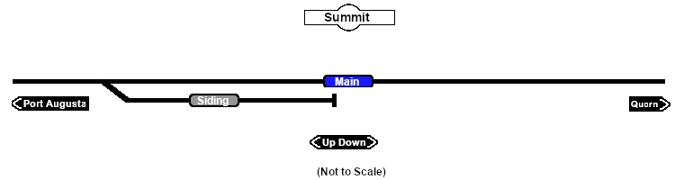
| − | + | <span style="font-weight: 700;"><span style="color: white; background-color: black;"> Distance from Port Augusta: </span> 32½ kms, 20 miles <span style="color: white; background-color: black;"> Distance from Quorn: </span> 7½ kms, 4½ miles</span><br> | |
| − | True to its name, it is the highest point on the line at 406m (1332ft).<br> | + | Unmanned location and dead end siding on the <span style="font-weight: 700; color: white; background-color: black;"> Port Augusta-Hawker Line </span>. True to its name, it is the highest point on the line at 406m (1332ft).<br> |
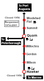
The line from '''Port Augusta''' to '''Quorn''' was closed in 1956 but the section from '''Quorn''' to '''Summit''' was still used by special passenger excursion trains from '''Peterborough''' in the 1960s.<br> | The line from '''Port Augusta''' to '''Quorn''' was closed in 1956 but the section from '''Quorn''' to '''Summit''' was still used by special passenger excursion trains from '''Peterborough''' in the 1960s.<br> | ||
| − | + | This location became part of the '''Pichi Richi Railway''' in 1974. The line from '''Quorn''' to '''Woolshed Flat''' was restored and reopened in 1979. | |
</td> | </td> | ||
</tr> | </tr> | ||
| Line 84: | Line 84: | ||
<td> | <td> | ||
[[Image:SAR_PortAugusta-Hawker_Line.png|link=SAR_Port Augusta-Hawker|alt=Port Augusta-Hawker|Show Port Augusta-Hawker]]<br> | [[Image:SAR_PortAugusta-Hawker_Line.png|link=SAR_Port Augusta-Hawker|alt=Port Augusta-Hawker|Show Port Augusta-Hawker]]<br> | ||
| − | [[Image: | + | [[Image:SAR_PortAugusta-Hawker Strip Map.png|link=|alt=Port Augusta-Hawker Strip Map]] |
</td> | </td> | ||
</tr> | </tr> | ||
</table> <!-- END TOP TABLE --> | </table> <!-- END TOP TABLE --> | ||
Latest revision as of 17:28, 13 February 2024
|
|