SAR Nackara V1

From TrainzOnline
Revision as of 07:14, 31 March 2024 by Pware (Talk | contribs)

(diff) ← Older revision | Latest revision (diff) | Newer revision → (diff)
Jump to: navigation, search
Line740.png
Tab HM White.png Tab IN Grey.png Tab TM Grey.png Tab SW Grey.png Tab Blank Grey.png
Line740.png
PortPirie-BrokenHill
Peechara
Location Index
Scenarios

Methuen
PortPirie-BrokenHill
Nackara map
This is the original v1.0 Nackara Map and description. For the latest SAR Peterborough Narrow Gauge Division v2.0 version click here. The v2.0 version of the route and sessions requires Trainz Plus or TRS22
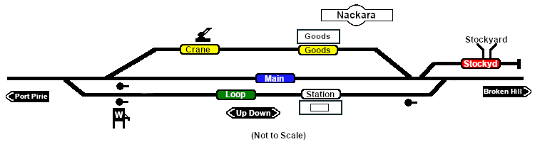
 Commodities: 
Passengers
Passengers
Station Label.png
Goods
Goods
Goods Label.png
Livestock
Livestock
Stockyard Label.png
   
 Loco Services: 
Water
Water
Main Label.png
Loop Label.png
   
 Facilities: 
Loop
Loop
Loop Label.png
     

 Distance from Peterborough:  45¾ kms, 28½ miles
Unmanned station on the  Port Pirie-Broken Hill Line .

Station/crossing and goods loops with a stockyard siding and loco watering facilities.

This location was bypassed when the line was converted to standard gauge (4ft8½in - 1435mm) during 1969-1970.

Line740.png

PortPirie-BrokenHill

Gladstone-Paratoo Strip Map
Personal tools