|
|
| (14 intermediate revisions by one user not shown) |
| Line 1: |
Line 1: |
| − | <!-- V1.0 and V2.0 versions in document --> | + | <!-- V1.0 --> |
| − | <!-- V2.0 Grain silos added, new map, trackmarks and industry pages -->
| + | |
| − | <!-- BEGIN V1.0 -->
| + | |
| | <table> | | <table> |
| | <tr valign="top"> | | <tr valign="top"> |
| Line 78: |
Line 76: |
| | <tr valign="top"> | | <tr valign="top"> |
| | <td> | | <td> |
| | + | <span style="font-weight: 700;"><span style="color: white; background-color: black;"> Distance from Gladstone: </span> 67 kms, 41¾ miles</span><br> |
| | + | |
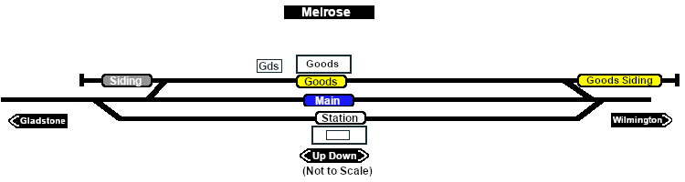
| | A manned station on the <span style="font-weight: 700; color: white; background-color: black;"> Gladstone-Wilmington Line </span> until 1983 when all the station staff on the line were withdrawn. The town of '''Melrose''' is just over a mile south of the station.<br> | | A manned station on the <span style="font-weight: 700; color: white; background-color: black;"> Gladstone-Wilmington Line </span> until 1983 when all the station staff on the line were withdrawn. The town of '''Melrose''' is just over a mile south of the station.<br> |
| | | | |
| Line 84: |
Line 84: |
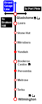
| | The '''Gladstone-Wilmington Line''' is '''unsignalled'''. Train Order working is in operation on the line.<br> | | The '''Gladstone-Wilmington Line''' is '''unsignalled'''. Train Order working is in operation on the line.<br> |
| | | | |
| − | There were no passenger services after 1969. The line was closed in 1990 and the track has since been removed. The right-of-way from '''Melrose''' to '''Wilmington''' has been converted into a rail trail. The site of the former '''Melrose''' station and yard is now occupied by a large grain receiving facility.
| + | Passenger services ended in 1969. The line was closed in 1990 and the track has since been removed.<br> |
| − | </td>
| + | |
| − | </tr> | + | |
| | | | |
| − | <tr valign="top">
| + | The site of the former '''Melrose''' station and yard is now occupied by a large grain receiving and storage facility.<br> |
| − | <td align="center">[[Image:line740.png|link=]]</td>
| + | |
| − | </tr>
| + | |
| − | | + | |
| − | </table> | + | |
| | | | |
| − | </td>
| + | The former right-of-way from just south of '''Laura''' to '''Wilmington''' is now an 80km walking, cycling and horse riding trail, the '''[https://www.railtrails.org.au/trails/southern-flinders-rail-trail/ Southern Flinders Rail Trail]'''. |
| − | <td>
| + | |
| − | [[Image:SAR_Gladstone-Wilmington_Line.png|link=SAR_Gladstone_Wilmington|alt=Gladstone-Wilmington|Show Gladstone-Wilmington]]<br>
| + | |
| − | [[Image:SAR_Gladstone-Wilmington Strip Map.png|link=|alt=Gladstone-Wilmington Strip Map]]
| + | |
| − | </td>
| + | |
| − | </tr>
| + | |
| − | </table>
| + | |
| − | <!-- END V1.0 -->
| + | |
| − | <!-- BEGIN V2.0
| + | |
| − | <table>
| + | |
| − | <tr valign="top">
| + | |
| − | <td width=750>
| + | |
| − | | + | |
| − | <table width=750>
| + | |
| − | <tr valign="top">
| + | |
| − | <td align="center">[[Image:line740.png|link=]]</td>
| + | |
| − | </tr>
| + | |
| − | <tr valign="top">
| + | |
| − | <td align="center">[[image:Tab_HM_White.png|link=]] [[image:Tab_IN_Grey.png|link=SAR_Melrose_Industry]] [[image:Tab_TM_Grey.png|link=SAR_Melrose_TrackMarks]] [[image:Tab_SW_Grey.png|link=SAR_Melrose_Switches]] [[image:Tab_Blank_Grey.png|link=]]</td>
| + | |
| − | </tr>
| + | |
| − | <tr valign="top">
| + | |
| − | <td align="center">[[Image:line740.png|link=]]</td>
| + | |
| − | </tr>
| + | |
| − | </table>
| + | |
| − | | + | |
| − | <table bgcolor="lightgrey" bordercolor="lightgrey" width=750>
| + | |
| − | | + | |
| − | <tr valign="middle">
| + | |
| − | <td width=220 align="right">[[Image:SAR_Gladstone-Wilmington_Line.png|link=SAR Gladstone-Wilmington|alt=Gladstone-Wilmington|Show Gladstone-Wilmington]]</td>
| + | |
| − | <td width=110 align="center">[[Image:Next Left.png|link=|alt=]]<br>[[Image:SAR_Peroomba_Name.png|link=SAR Peroomba|alt=Peroomba|Next Up Location]]</td>
| + | |
| − | <td width=90 align="center">[[Image:Location Index.png|link=SAR Index|alt=Location Index|Location Index]]<br>[[image:Scenario Index.png|link=SAR Peterborough Base Session|alt=Scenarios|Scenario Index]]</td>
| + | |
| − | <td width=110 align="center">[[Image:Next Right.png|link=|alt=]]<br>[[Image:SAR_Terka_Name.png|link=SAR Terka|alt=Terka|Next Down Location]]</td>
| + | |
| − | <td width=220 align="left">[[Image:SAR_Gladstone-Wilmington_Line.png|link=SAR Gladstone-Wilmington|alt=Gladstone-Wilmington|Show Gladstone-Wilmington]]</td>
| + | |
| − | </tr>
| + | |
| − | | + | |
| − | </table>
| + | |
| − | | + | |
| − | <table width=750>
| + | |
| − | <tr valign="top">
| + | |
| − | <td>[[image:SAR_Melrose.png|link=|alt=Melrose map]]</td>
| + | |
| − | </td>
| + | |
| − | </tr>
| + | |
| − | <tr valign="top">
| + | |
| − | <td align="center"><span style="font-weight: 700;">Map and commodities updated in <span style="color: blue;">SAR Peterborough Narrow Gauge Division v2.0</span></span><br>
| + | |
| − | [[Image:line740.png|link=]]</td>
| + | |
| − | </tr>
| + | |
| − | </table>
| + | |
| − | | + | |
| − | <table bgcolor="lightgrey" bordercolor="lightgrey" width=750>
| + | |
| − | | + | |
| − | <tr valign="top">
| + | |
| − | <td><span style="font-weight: 700; background-color: black; color: white;"> Commodities: </span>
| + | |
| − | | + | |
| − | <table width=300>
| + | |
| − | <tr valign="top">
| + | |
| − | | + | |
| − | <td align="center" width=50>[[Image:Passenger_Icon_off.png|link=|alt=Passengers]]<br><span style="font-size: 10px; font-weight: 700;">Passengers</span><br>[[image:Station_Label.png|link=]]</td>
| + | |
| − | <td align="center" width=50>[[Image:Goods_Icon.png|link=|alt=Goods]]<br><span style="font-size: 10px; font-weight: 700;">Goods</span><br>[[image:Goods_Label.png|link=]]</td>
| + | |
| − | <td align="center" width=50>[[Image:Grain_Icon.png|link=|alt=Grain]]<br><span style="font-size: 10px; font-weight: 700;">Grain</span><br>[[image:Grain_Label.png|link=]]</td>
| + | |
| − | <td align="center" width=50> </td>
| + | |
| − | <td align="center" width=50> </td>
| + | |
| − | | + | |
| − | </tr>
| + | |
| − | </table>
| + | |
| − | | + | |
| − | </td>
| + | |
| − | <td>
| + | |
| − | | + | |
| − | <table width=175>
| + | |
| − | <tr valign="top">
| + | |
| − | | + | |
| − | <td width=175> </td>
| + | |
| − | | + | |
| − | </tr>
| + | |
| − | </table>
| + | |
| − | | + | |
| − | </td>
| + | |
| − | <td>
| + | |
| − | | + | |
| − | <table width=250>
| + | |
| − | <tr valign="top">
| + | |
| − | | + | |
| − | <td width=250> </td>
| + | |
| − | | + | |
| − | </tr>
| + | |
| − | </table>
| + | |
| − | | + | |
| − | </td>
| + | |
| − | </tr>
| + | |
| − | </table>
| + | |
| − | | + | |
| − | <table with=750>
| + | |
| − | <tr valign="top">
| + | |
| − | <td>
| + | |
| − | A manned station on the <span style="font-weight: 700; color: white; background-color: black;"> Gladstone-Wilmington Line </span> until 1983 when all the station staff on the line were withdrawn. The town of '''Melrose''' is just over a mile south of the station.<br>
| + | |
| − | | + | |
| − | Station and goods loops, with grain and goods sidings.<br>
| + | |
| − | | + | |
| − | The '''Gladstone-Wilmington Line''' is '''unsignalled'''. Train Order working is in operation on the line.<br>
| + | |
| − | | + | |
| − | There were no passenger services after 1969. The line was closed in 1990 and the track has since been removed. The right-of-way from '''Melrose''' to '''Wilmington''' has been converted into a rail trail. The site of the former '''Melrose''' station and yard is now occupied by a large grain receiving facility. The original yard crane is now on display with interpretive panels at the nearby Melrose Showgrounds.
| + | |
| | </td> | | </td> |
| | </tr> | | </tr> |
| Line 211: |
Line 105: |
| | </tr> | | </tr> |
| | </table> | | </table> |
| − |
| |
| − | END V2.0 -->
| |