SAR Jamestown V2

From TrainzOnline
Revision as of 20:18, 26 April 2024 by Pware (Talk | contribs)

(diff) ← Older revision | Latest revision (diff) | Newer revision → (diff)
Jump to: navigation, search
Line740.png
Tab HM White.png Tab IN Grey.png Tab TM Grey.png Tab SW Grey.png Tab Blank Grey.png
Line740.png
PortPirie-BrokenHill
Caltowie
Location Index
Scenarios

Belalie North
PortPirie-BrokenHill
Jamestown map
Updated for SAR Peterborough Narrow Gauge Division v2.0. For the original V1.0 version click here

V2.0 requires Trainz Plus or TRS22 to run

Line740.png
 Commodities: 
Passengers
Passengers
Station Label.png
Goods
Goods
Goods Label.png
Grain
Grain
Grain Label.png
   
 Loco Services: 
Coal
Coal
Loco Label.png
Water
Water
Loco Label.png
 
 Facilities: 
Loop
Loop
Loop Label.png
Turntable
Turntable
Loco Label.png
   

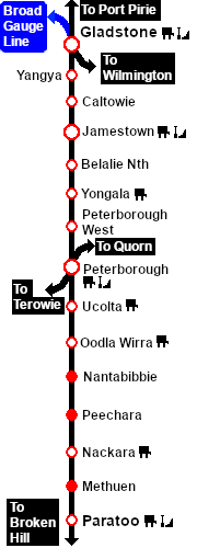
 Distance from Gladstone:  30½ kms, 19 miles  from Peterborough:  35 kms, 21¾ miles

Manned station on the  Port Pirie-Broken Hill Line .

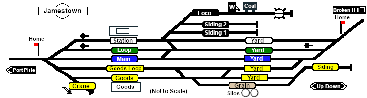
Multiple loops and sidings including goods, grain and storage. Loco servicing facility.

After the conversion of the line to standard gauge (4ft8½in - 1435mm) in 1969-70 Jamestown became just a crossing loop with sidings and a new grain terminal. The goods and servicing facilities have been removed.

The station building is being reused as a local museum. There are no longer any passenger services.

Line740.png

PortPirie-BrokenHill

Gladstone-Paratoo Strip Map
Personal tools