From TrainzOnline
(Difference between revisions)
Revision as of 22:37, 28 March 2024
 |
This is the original v1.0 Jamestown Map and description. For the latest SAR Peterborough Narrow Gauge Division v2.0 version click here. The v2.0 version of the route and sessions requires Trainz Plus or TRS22
 |
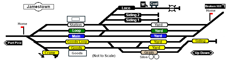
| Commodities:
|
Loco Services:
|
Facilities:
|
|
Distance from Gladstone: 30½ kms, 19 miles from Peterborough: 35 kms, 21¾ miles
Manned station on the Port Pirie-Broken Hill Line .
Multiple loops and sidings including goods, grain and storage. Loco servicing facility.
After the conversion of the line to standard gauge (4ft8½in - 1435mm) in 1969-70 Jamestown became just a crossing loop with sidings and a new grain terminal. The goods and servicing facilities have been removed.
The station building is being reused as a local museum. There are no longer any passenger services.
|
|
|

 |
