SAR Changes Log
m |
m |
||
| (10 intermediate revisions by one user not shown) | |||
| Line 1: | Line 1: | ||
<table width=1000> | <table width=1000> | ||
| + | <tr valign="top"> | ||
| + | <td align="center"><span style="font-weight: 700; font-size: 17px;"> SAR Peterborough Narrow Gauge Division </span></td> | ||
| + | </tr> | ||
<tr valign="top"> | <tr valign="top"> | ||
<td align="center"><span style="font-weight: 700; font-size: 17px; color: white; background-color: black;"> Changes Between Version 1.0 and Version 2.0 </span></td> | <td align="center"><span style="font-weight: 700; font-size: 17px; color: white; background-color: black;"> Changes Between Version 1.0 and Version 2.0 </span></td> | ||
</tr> | </tr> | ||
<tr valign="top"> | <tr valign="top"> | ||
| − | <td> | + | <td>'''Version 1.0''' of the route and base session were created for '''TRS19 (SP3)''' and above. '''Version 2.0''' of the route and base session were created for '''TRS22 (SP3)''' and '''Trainz Plus''' and above.<br> |
| − | + | Most of the changes made to the maps, industries, switches and track marks between the two versions are due to more up to date historical information becoming available.<br> | |
| − | + | I recently gained access to a vast online archive of historical photographs and documents covering all Australian railways. As a result I have noted, in most cases, minor differences and, in a few cases, major differences between the details revealed in the archive and the original published material on which the Peterborough Division route was based. Those location where differences were discovered have been updated in '''Version 2.0''' of the route, session and scenarios.<br> | |
| − | ''' | + | |
The changes made are:-</td> | The changes made are:-</td> | ||
</tr> | </tr> | ||
</table> | </table> | ||
| + | [[Image:line740.png|link=]]<br> | ||
<span style="font-weight: 700; font-size: 15px; color: white; background-color: blue;"> Port Pirie to Broken Hill Line </span> | <span style="font-weight: 700; font-size: 15px; color: white; background-color: blue;"> Port Pirie to Broken Hill Line </span> | ||
<table width=1000> | <table width=1000> | ||
| + | <tr valign="top"> | ||
| + | <td> | ||
| + | <table width=750> | ||
<tr valign="top"> | <tr valign="top"> | ||
<td colspan=2><span style="font-weight: 700; font-size: 15px; color: white; background-color: black;"> Gladstone: </span></td> | <td colspan=2><span style="font-weight: 700; font-size: 15px; color: white; background-color: black;"> Gladstone: </span></td> | ||
| Line 21: | Line 27: | ||
<tr valign="top"> | <tr valign="top"> | ||
<td width=10>[[image:DotPoint.JPG|10px|link=]]</td> | <td width=10>[[image:DotPoint.JPG|10px|link=]]</td> | ||
| − | <td>Grain silos have been added. This has altered track marks and switches as well as adding another interactive grain industry asset</td> | + | <td>Grain silos have been added in addition to the grain terminal that was already present. This has altered track marks and switches as well as adding another interactive grain industry asset</td> |
</tr> | </tr> | ||
<tr valign="top"> | <tr valign="top"> | ||
| Line 33: | Line 39: | ||
</table> | </table> | ||
<br> | <br> | ||
| − | <table width= | + | <table width=750> |
<tr valign="top"> | <tr valign="top"> | ||
<td colspan=2><span style="font-weight: 700; font-size: 15px; color: white; background-color: black;"> Caltowie: </span></td> | <td colspan=2><span style="font-weight: 700; font-size: 15px; color: white; background-color: black;"> Caltowie: </span></td> | ||
| Line 43: | Line 49: | ||
</table> | </table> | ||
<br> | <br> | ||
| − | <table width= | + | <table width=750> |
<tr valign="top"> | <tr valign="top"> | ||
<td colspan=2><span style="font-weight: 700; font-size: 15px; color: white; background-color: black;"> Jamestown: </span></td> | <td colspan=2><span style="font-weight: 700; font-size: 15px; color: white; background-color: black;"> Jamestown: </span></td> | ||
| Line 57: | Line 63: | ||
</table> | </table> | ||
<br> | <br> | ||
| − | <table width= | + | <table width=750> |
<tr valign="top"> | <tr valign="top"> | ||
<td colspan=2><span style="font-weight: 700; font-size: 15px; color: white; background-color: black;"> Belalie North: </span></td> | <td colspan=2><span style="font-weight: 700; font-size: 15px; color: white; background-color: black;"> Belalie North: </span></td> | ||
| Line 67: | Line 73: | ||
</table> | </table> | ||
<br> | <br> | ||
| − | <table width= | + | <table width=750> |
<tr valign="top"> | <tr valign="top"> | ||
<td colspan=2><span style="font-weight: 700; font-size: 15px; color: white; background-color: black;"> Yongala: </span></td> | <td colspan=2><span style="font-weight: 700; font-size: 15px; color: white; background-color: black;"> Yongala: </span></td> | ||
| Line 81: | Line 87: | ||
</table> | </table> | ||
<br> | <br> | ||
| − | <table width= | + | <table width=750> |
<tr valign="top"> | <tr valign="top"> | ||
<td colspan=2><span style="font-weight: 700; font-size: 15px; color: white; background-color: black;"> Peterborough West: </span></td> | <td colspan=2><span style="font-weight: 700; font-size: 15px; color: white; background-color: black;"> Peterborough West: </span></td> | ||
| Line 87: | Line 93: | ||
<tr valign="top"> | <tr valign="top"> | ||
<td width=10>[[image:DotPoint.JPG|10px|link=]]</td> | <td width=10>[[image:DotPoint.JPG|10px|link=]]</td> | ||
| − | <td>This is a new location not present in V1. A simple passenger halt with a basic passenger shelter and no other infrastructure. Its | + | <td>This is a new location not present in V1. A simple passenger halt with a basic passenger shelter and no other infrastructure. Its presence was identified in a single photograph but its exact location is educated "guesswork"</td> |
</tr> | </tr> | ||
<tr valign="top"> | <tr valign="top"> | ||
| Line 95: | Line 101: | ||
</table> | </table> | ||
<br> | <br> | ||
| − | <table width= | + | <table width=750> |
<tr valign="top"> | <tr valign="top"> | ||
<td colspan=2><span style="font-weight: 700; font-size: 15px; color: white; background-color: black;"> Peterborough: </span></td> | <td colspan=2><span style="font-weight: 700; font-size: 15px; color: white; background-color: black;"> Peterborough: </span></td> | ||
| Line 105: | Line 111: | ||
</table> | </table> | ||
<br> | <br> | ||
| − | <table width= | + | <table width=750> |
<tr valign="top"> | <tr valign="top"> | ||
<td colspan=2><span style="font-weight: 700; font-size: 15px; color: white; background-color: black;"> Ucolta: </span></td> | <td colspan=2><span style="font-weight: 700; font-size: 15px; color: white; background-color: black;"> Ucolta: </span></td> | ||
| Line 115: | Line 121: | ||
</table> | </table> | ||
<br> | <br> | ||
| − | <table width= | + | <table width=750> |
<tr valign="top"> | <tr valign="top"> | ||
<td colspan=2><span style="font-weight: 700; font-size: 15px; color: white; background-color: black;"> Oodla Wirra: </span></td> | <td colspan=2><span style="font-weight: 700; font-size: 15px; color: white; background-color: black;"> Oodla Wirra: </span></td> | ||
| Line 125: | Line 131: | ||
</table> | </table> | ||
<br> | <br> | ||
| − | <table width= | + | <table width=750> |
<tr valign="top"> | <tr valign="top"> | ||
<td colspan=2><span style="font-weight: 700; font-size: 15px; color: white; background-color: black;"> Nackara: </span></td> | <td colspan=2><span style="font-weight: 700; font-size: 15px; color: white; background-color: black;"> Nackara: </span></td> | ||
| Line 132: | Line 138: | ||
<td width=10>[[image:DotPoint.JPG|10px|link=]]</td> | <td width=10>[[image:DotPoint.JPG|10px|link=]]</td> | ||
<td>Additional water column and track marks added</td> | <td>Additional water column and track marks added</td> | ||
| + | </tr> | ||
| + | <tr valign="top"> | ||
| + | <td>[[image:DotPoint.JPG|10px|link=]]</td> | ||
| + | <td>Goods siding added</td> | ||
</tr> | </tr> | ||
</table> | </table> | ||
<br> | <br> | ||
| − | <table width= | + | <table width=750> |
<tr valign="top"> | <tr valign="top"> | ||
<td colspan=2><span style="font-weight: 700; font-size: 15px; color: white; background-color: black;"> Paratoo: </span></td> | <td colspan=2><span style="font-weight: 700; font-size: 15px; color: white; background-color: black;"> Paratoo: </span></td> | ||
| Line 144: | Line 154: | ||
</tr> | </tr> | ||
</table> | </table> | ||
| + | </td> | ||
| + | <td width=250>[[Image:SAR_PortPirie-BrokenHill_Line.png|link=SAR_Port_Pirie-Broken_Hill_V2|alt=PortPirie-BrokenHill|Show Port Pirie-Broken Hill]]<br> | ||
| + | [[Image:SAR_Gladstone-Paratoo Strip Map.png|link=|alt=Gladstone-Paratoo Strip Map]]</td> | ||
| + | </tr> | ||
| + | </table> | ||
| + | <br> | ||
| + | [[Image:line740.png|link=]]<br> | ||
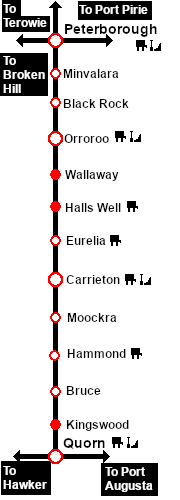
<span style="font-weight: 700; font-size: 15px; color: white; background-color: blue;"> Peterborough to Quorn Line </span> | <span style="font-weight: 700; font-size: 15px; color: white; background-color: blue;"> Peterborough to Quorn Line </span> | ||
<table width=1000> | <table width=1000> | ||
| + | <tr valign="top"> | ||
| + | <td> | ||
| + | <table width=750> | ||
<tr valign="top"> | <tr valign="top"> | ||
<td colspan=2><span style="font-weight: 700; font-size: 15px; color: white; background-color: black;"> Orroroo: </span></td> | <td colspan=2><span style="font-weight: 700; font-size: 15px; color: white; background-color: black;"> Orroroo: </span></td> | ||
| Line 151: | Line 171: | ||
<tr valign="top"> | <tr valign="top"> | ||
<td width=10>[[image:DotPoint.JPG|10px|link=]]</td> | <td width=10>[[image:DotPoint.JPG|10px|link=]]</td> | ||
| − | <td> | + | <td>A catchpoint has been added at the Down Goods</td> |
</tr> | </tr> | ||
<tr valign="top"> | <tr valign="top"> | ||
<td>[[image:DotPoint.JPG|10px|link=]]</td> | <td>[[image:DotPoint.JPG|10px|link=]]</td> | ||
| − | <td> | + | <td>Additional water columns and track marks have been added</td> |
</tr> | </tr> | ||
</table> | </table> | ||
<br> | <br> | ||
| − | <table width= | + | <table width=750> |
| + | <tr valign="top"> | ||
| + | <td colspan=2><span style="font-weight: 700; font-size: 15px; color: white; background-color: black;"> Eurelia: </span></td> | ||
| + | </tr> | ||
| + | <tr valign="top"> | ||
| + | <td width=10>[[image:DotPoint.JPG|10px|link=]]</td> | ||
| + | <td>Additional water columns and track marks have been added</td> | ||
| + | </tr> | ||
| + | </table> | ||
| + | <br> | ||
| + | <table width=750> | ||
| + | <tr valign="top"> | ||
| + | <td colspan=2><span style="font-weight: 700; font-size: 15px; color: white; background-color: black;"> Carrieton: </span></td> | ||
| + | </tr> | ||
| + | <tr valign="top"> | ||
| + | <td width=10>[[image:DotPoint.JPG|10px|link=]]</td> | ||
| + | <td>Additional water columns and track marks have been added</td> | ||
| + | </tr> | ||
| + | </table> | ||
| + | <br> | ||
| + | <table width=750> | ||
<tr valign="top"> | <tr valign="top"> | ||
<td colspan=2><span style="font-weight: 700; font-size: 15px; color: white; background-color: black;"> Quorn: </span></td> | <td colspan=2><span style="font-weight: 700; font-size: 15px; color: white; background-color: black;"> Quorn: </span></td> | ||
| Line 174: | Line 214: | ||
<td>[[image:DotPoint.JPG|10px|link=]]</td> | <td>[[image:DotPoint.JPG|10px|link=]]</td> | ||
<td>One goods siding road converted to a stockyard siding</td> | <td>One goods siding road converted to a stockyard siding</td> | ||
| + | </tr> | ||
| + | </table> | ||
| + | </td> | ||
| + | <td width=250>[[Image:SAR_Peterborough-Quorn_Line.png|link=SAR Peterborough-Quorn_V2|alt=Port Peterborough-Quorn Line|Show Peterborough-Quorn Line]]<br> | ||
| + | [[Image:SAR_Peterborough-Quorn Strip Map.png|link=|alt=Peterborough-Quorn Strip Map]]</td> | ||
</tr> | </tr> | ||
</table> | </table> | ||
<br> | <br> | ||
| + | [[Image:line740.png|link=]]<br> | ||
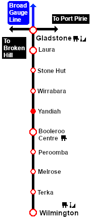
<span style="font-weight: 700; font-size: 15px; color: white; background-color: blue;"> Gladstone to Wilmington Line </span> | <span style="font-weight: 700; font-size: 15px; color: white; background-color: blue;"> Gladstone to Wilmington Line </span> | ||
<br> | <br> | ||
<table width=1000> | <table width=1000> | ||
| + | <tr valign="top"> | ||
| + | <td> | ||
| + | <table width=750> | ||
<tr valign="top"> | <tr valign="top"> | ||
<td colspan=2><span style="font-weight: 700; font-size: 15px; color: white; background-color: black;"> Wirrabara: </span></td> | <td colspan=2><span style="font-weight: 700; font-size: 15px; color: white; background-color: black;"> Wirrabara: </span></td> | ||
| Line 189: | Line 238: | ||
</table> | </table> | ||
<br> | <br> | ||
| − | <table width= | + | <table width=750> |
<tr valign="top"> | <tr valign="top"> | ||
<td colspan=2><span style="font-weight: 700; font-size: 15px; color: white; background-color: black;"> Yandiah: </span></td> | <td colspan=2><span style="font-weight: 700; font-size: 15px; color: white; background-color: black;"> Yandiah: </span></td> | ||
| Line 199: | Line 248: | ||
<tr valign="top"> | <tr valign="top"> | ||
<td>[[image:DotPoint.JPG|10px|link=]]</td> | <td>[[image:DotPoint.JPG|10px|link=]]</td> | ||
| − | <td>Passenger Halt track mark added to main line</td> | + | <td>Passenger Halt track mark added to main line. Yandiah was timetabled as a passenger halt even though it lacked any passenger facilities</td> |
</tr> | </tr> | ||
</table> | </table> | ||
<br> | <br> | ||
| − | <table width= | + | <table width=750> |
<tr valign="top"> | <tr valign="top"> | ||
<td colspan=2><span style="font-weight: 700; font-size: 15px; color: white; background-color: black;"> Booleroo Centre: </span></td> | <td colspan=2><span style="font-weight: 700; font-size: 15px; color: white; background-color: black;"> Booleroo Centre: </span></td> | ||
| Line 229: | Line 278: | ||
</table> | </table> | ||
<br> | <br> | ||
| − | <table width= | + | <table width=750> |
<tr valign="top"> | <tr valign="top"> | ||
<td colspan=2><span style="font-weight: 700; font-size: 15px; color: white; background-color: black;"> Peroomba: </span></td> | <td colspan=2><span style="font-weight: 700; font-size: 15px; color: white; background-color: black;"> Peroomba: </span></td> | ||
| Line 235: | Line 284: | ||
<tr valign="top"> | <tr valign="top"> | ||
<td width=10>[[image:DotPoint.JPG|10px|link=]]</td> | <td width=10>[[image:DotPoint.JPG|10px|link=]]</td> | ||
| − | <td>A passenger shelter has been added to the loop with track marks</td> | + | <td>A passenger shelter has been added to the loop with track marks. Peroomba was timetabled as a passenger stop</td> |
</tr> | </tr> | ||
</table> | </table> | ||
<br> | <br> | ||
| − | <table width= | + | <table width=750> |
<tr valign="top"> | <tr valign="top"> | ||
<td colspan=2><span style="font-weight: 700; font-size: 15px; color: white; background-color: black;"> Melrose: </span></td> | <td colspan=2><span style="font-weight: 700; font-size: 15px; color: white; background-color: black;"> Melrose: </span></td> | ||
| Line 253: | Line 302: | ||
</table> | </table> | ||
<br> | <br> | ||
| − | <table width= | + | <table width=750> |
<tr valign="top"> | <tr valign="top"> | ||
<td colspan=2><span style="font-weight: 700; font-size: 15px; color: white; background-color: black;"> Wilmington: </span></td> | <td colspan=2><span style="font-weight: 700; font-size: 15px; color: white; background-color: black;"> Wilmington: </span></td> | ||
| Line 260: | Line 309: | ||
<td width=10>[[image:DotPoint.JPG|10px|link=]]</td> | <td width=10>[[image:DotPoint.JPG|10px|link=]]</td> | ||
<td>A stockyard has been added on the WYE</td> | <td>A stockyard has been added on the WYE</td> | ||
| + | </tr> | ||
| + | </table> | ||
| + | </td> | ||
| + | <td width=250>[[Image:SAR_Gladstone-Wilmington_Line.png|link=SAR_Gladstone-Wilmington_V2|alt=Gladstone-Wilmington|Show Gladstone-Wilmington]]<br> | ||
| + | [[Image:SAR_Gladstone-Wilmington Strip Map_V2.png|link=|alt=Gladstone-Wilmington Strip Map]]</td> | ||
</tr> | </tr> | ||
</table> | </table> | ||
<br> | <br> | ||
| − | <span style="font-weight: 700; font-size: 15px; color: white; background-color: blue;">  | + | [[Image:line740.png|link=]]<br> |
| + | <span style="font-weight: 700; font-size: 15px; color: white; background-color: blue;"> Base Session </span> | ||
<br> | <br> | ||
| − | <span style="font-weight: 700; font-size: 15px; color: white; background-color: | + | More rolling stock has been added.<br> |
| − | + | <br> | |
| − | + | [[Image:line740.png|link=]]<br> | |
| − | + | <span style="font-weight: 700; font-size: 15px; color: white; background-color: blue;"> V2.0 Scenarios </span> | |
| + | <br> | ||
| + | <span style="font-weight: 700; font-size: 15px; color: white; background-color: black;"> Original Scenarios: </span><br> | ||
| + | <table width=1000> | ||
| + | <tr valign="top"> | ||
| + | <td>Most of these have been updated to take advantage of the changes that have been made to many of the location in the route. All the V1.0 scenarios have been renamed to include '''V2''' in their Wiki name and have had their links updated. In all scenarios a link has been provided to the original V1.0 version. Most of the scenarios have been provided with a sample timetable for one or several trains that could be run.</td> | ||
| + | </tr> | ||
| + | </table> | ||
<br> | <br> | ||
<span style="font-weight: 700; font-size: 15px; color: white; background-color: black;"> New V2.0 Scenarios: </span><br> | <span style="font-weight: 700; font-size: 15px; color: white; background-color: black;"> New V2.0 Scenarios: </span><br> | ||
| + | |||
| + | <table width=1000> | ||
| + | <tr valign="top"> | ||
| + | <td>The new '''V2.0''' scenarios make use of additional rolling stock that has been added to the '''SAR Peterborough Division Base Session V2.0''' and the additional trackage from '''Woolshed Flats''' to '''Hawker'''. Most have also been provided with a sample timetable for one or several trains that could be run. | ||
| + | </td> | ||
| + | </tr> | ||
| + | </table> | ||
| + | [[Image:line740.png|link=]]<br> | ||
Latest revision as of 02:27, 17 May 2024
| SAR Peterborough Narrow Gauge Division |
| Changes Between Version 1.0 and Version 2.0 |
| Version 1.0 of the route and base session were created for TRS19 (SP3) and above. Version 2.0 of the route and base session were created for TRS22 (SP3) and Trainz Plus and above. Most of the changes made to the maps, industries, switches and track marks between the two versions are due to more up to date historical information becoming available. I recently gained access to a vast online archive of historical photographs and documents covering all Australian railways. As a result I have noted, in most cases, minor differences and, in a few cases, major differences between the details revealed in the archive and the original published material on which the Peterborough Division route was based. Those location where differences were discovered have been updated in Version 2.0 of the route, session and scenarios. |
![]()
Port Pirie to Broken Hill Line
|
 |
||||||||||||||||||||||||||||||||||||||||||||||||||||||||
![]()
Peterborough to Quorn Line
|
 |
||||||||||||||||||||||
![]()
Gladstone to Wilmington Line
|
 |
||||||||||||||||||||||||||||||||||||
![]()
Base Session
More rolling stock has been added.
![]()
V2.0 Scenarios
Original Scenarios:
| Most of these have been updated to take advantage of the changes that have been made to many of the location in the route. All the V1.0 scenarios have been renamed to include V2 in their Wiki name and have had their links updated. In all scenarios a link has been provided to the original V1.0 version. Most of the scenarios have been provided with a sample timetable for one or several trains that could be run. |
New V2.0 Scenarios:
| The new V2.0 scenarios make use of additional rolling stock that has been added to the SAR Peterborough Division Base Session V2.0 and the additional trackage from Woolshed Flats to Hawker. Most have also been provided with a sample timetable for one or several trains that could be run. |
![]()