|
|
| (7 intermediate revisions by one user not shown) |
| Line 1: |
Line 1: |
| − | <!-- V1.0 and V2.0 versions --> | + | <!-- V1.0 --> |
| − | <!-- grain silos moved in map, new trackmarks page -->
| + | |
| − | <!-- BEGIN V1.0 -->
| + | |
| | <table> | | <table> |
| | <tr valign="top"> | | <tr valign="top"> |
| Line 80: |
Line 78: |
| | <tr valign="top"> | | <tr valign="top"> |
| | <td width=750> | | <td width=750> |
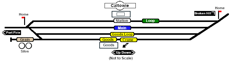
| − | Manned station on the <span style="font-weight: 700; color: white; background-color: black;"> Port Pirie-Broken Hill Line </span>.<br>
| + | <span style="font-weight: 700;"><span style="color: white; background-color: black;"> Distance from Gladstone: </span> 18 kms, 11½ miles <span style="color: white; background-color: black;"> from Peterborough: </span> 47½ kms, 29½ miles</span><br> |
| | | | |
| − | Station, goods and passing loops with a grain siding.<br>
| |
| − |
| |
| − | After the conversion of the line to standard gauge (1969-70) '''Caltowie''' became a passing loop and a grain terminal. Passenger services no longer stop at '''Caltowie'''.
| |
| − | </td>
| |
| − | </tr>
| |
| − | <tr valign="top">
| |
| − | <td align="center">[[Image:line740.png|link=]]</td>
| |
| − | </tr>
| |
| − |
| |
| − | </table>
| |
| − |
| |
| − | </td>
| |
| − | <td>
| |
| − | [[Image:SAR_PortPirie-BrokenHill_Line.png|link=SAR_Port_Pirie-Broken_Hill|alt=PortPirie-BrokenHill|Show Port Pirie-Broken Hill]]<br>
| |
| − | [[Image:SAR_Gladstone-Paratoo Strip Map.png|link=|alt=Gladstone-Paratoo Strip Map]]</td>
| |
| − | </tr>
| |
| − | </table>
| |
| − |
| |
| − | <!-- END V1.0 -->
| |
| − | <!-- BEGIN V2.0
| |
| − | <table>
| |
| − | <tr valign="top">
| |
| − | <td width=750>
| |
| − |
| |
| − | <table width=750>
| |
| − | <tr valign="top">
| |
| − | <td align="center">[[Image:line740.png|link=]]</td>
| |
| − | </tr>
| |
| − | <tr valign="top">
| |
| − | <td align="center">[[image:Tab_HM_White.png|link=]] [[image:Tab_IN_Grey.png|link=SAR_Caltowie_Industry]] [[image:Tab_TM_Grey.png|link=SAR_Caltowie_TrackMarks]] [[image:Tab_SW_Grey.png|link=SAR_Caltowie_Switches]] [[image:Tab_Blank_Grey.png|link=]]</td>
| |
| − | </tr>
| |
| − | <tr valign="top">
| |
| − | <td align="center">[[Image:line740.png|link=]]</td>
| |
| − | </tr>
| |
| − | </table>
| |
| − |
| |
| − | <table bgcolor="lightgrey" bordercolor="lightgrey" width=750>
| |
| − |
| |
| − | <tr valign="middle">
| |
| − | <td width=220 align="right">[[Image:SAR_PortPirie-BrokenHill_Line.png|link=SAR_Port_Pirie-Broken_Hill|alt=PortPirie-BrokenHill|Show Port Pirie-Broken Hill]]</td>
| |
| − | <td width=110 align="center">[[Image:Next Left.png|link=|alt=]]<br>[[Image:SAR_Yangya_Name.png|link=SAR Yangya|alt=Gladstone|Next Up Location]]</td>
| |
| − | <td width=90 align="center">[[Image:Location Index.png|link=SAR Index|alt=Location Index|Location Index]]<br>[[image:Scenario Index.png|link=SAR Peterborough Base Session|alt=Scenarios|Scenario Index]]</td>
| |
| − | <td width=110 align="center">[[Image:Next Right.png|link=|alt=]]<br>[[Image:SAR_Jamestown_Name.png|link=SAR Jamestown|alt=Caltowie|Next Down Location]]</td>
| |
| − | <td width=220 align="left">[[Image:SAR_PortPirie-BrokenHill_Line.png|link=SAR_Port_Pirie-Broken_Hill|alt=PortPirie-BrokenHill|Show Port Pirie-Broken Hill]]</td>
| |
| − | </tr>
| |
| − |
| |
| − | </table>
| |
| − |
| |
| − | <table width=750>
| |
| − | <tr valign="top">
| |
| − | <td>[[image:SAR_Caltowie.png|link=|alt=Caltowie map]]</td>
| |
| − | <tr valign="top">
| |
| − | <td align="center"><span style="font-weight: 700;">Map updated in <span style="color: blue;">SAR Peterborough Narrow Gauge Division v2.0</span></span><br>
| |
| − | [[Image:line740.png|link=]]</td>
| |
| − | </tr>
| |
| − | </table>
| |
| − |
| |
| − | <table bgcolor="lightgrey" bordercolor="lightgrey" width=750>
| |
| − |
| |
| − | <tr valign="top">
| |
| − | <td><span style="font-weight: 700; background-color: black; color: white;"> Commodities: </span>
| |
| − |
| |
| − | <table width=300>
| |
| − | <tr valign="top">
| |
| − |
| |
| − | <td align="center" width=50>[[Image:Passenger_Icon_off.png|link=|alt=Passengers]]<br><span style="font-size: 10px; font-weight: 700;">Passengers</span><br>[[image:Station_Label.png|link=]]</td>
| |
| − | <td align="center" width=50>[[Image:Goods_Icon.png|link=|alt=Goods]]<br><span style="font-size: 10px; font-weight: 700;">Goods</span><br>[[image:Goods_Label.png|link=]]</td>
| |
| − | <td align="center" width=50>[[Image:Grain_Icon.png|link=|alt=Grain]]<br><span style="font-size: 10px; font-weight: 700;">Grain</span><br>[[image:Grain_Label.png|link=]]</td>
| |
| − | <td align="center" width=50> </td>
| |
| − | <td align="center" width=50> </td>
| |
| − |
| |
| − | </tr>
| |
| − | </table>
| |
| − |
| |
| − | </td>
| |
| − | <td>
| |
| − |
| |
| − | <table width=175>
| |
| − | <tr valign="top">
| |
| − |
| |
| − | <td width=175> </td>
| |
| − |
| |
| − | </tr>
| |
| − | </table>
| |
| − |
| |
| − | </td>
| |
| − | <td><span style="font-weight: 700;"><span style="background-color: black; color: white;"> Facilities: </span></span>
| |
| − |
| |
| − | <table width=250>
| |
| − | <tr valign="top">
| |
| − |
| |
| − | <td align="center" width=50>[[Image:Loop_Icon.png|link=|alt=Loop]]<br><span style="font-size: 10px; font-weight: 700;">Loop</span><br>[[image:Loop_Label.png|link=]]</td>
| |
| − | <td align="center" width=50> </td>
| |
| − | <td align="center" width=50> </td>
| |
| − | <td align="center" width=50> </td>
| |
| − |
| |
| − | </tr>
| |
| − | </table>
| |
| − |
| |
| − | </td>
| |
| − | </tr>
| |
| − | </table>
| |
| − |
| |
| − | <table>
| |
| − |
| |
| − | <tr valign="top">
| |
| − | <td width=750>
| |
| | Manned station on the <span style="font-weight: 700; color: white; background-color: black;"> Port Pirie-Broken Hill Line </span>.<br> | | Manned station on the <span style="font-weight: 700; color: white; background-color: black;"> Port Pirie-Broken Hill Line </span>.<br> |
| | | | |
| − | Station, goods and grain loop, and a passing loops.<br> | + | Station loop, goods and grain loop, a goods loop, and a grain storage siding.<br> |
| | | | |
| − | After the conversion of the line to standard gauge (1969-70) '''Caltowie''' became a passing loop and a grain terminal. Passenger services no longer stop at '''Caltowie'''. | + | After the conversion of the line to standard gauge (4ft8½in - 1434mm) in 1969-70 '''Caltowie''' became just a crossing loop and a grain terminal. There are no passenger services. |
| | </td> | | </td> |
| | </tr> | | </tr> |
| Line 208: |
Line 99: |
| | </tr> | | </tr> |
| | </table> | | </table> |
| − | END V2.0 -->
| |