SAR Belalie North

From TrainzOnline
Revision as of 21:56, 3 December 2020 by Pware (Talk | contribs)

Jump to: navigation, search
Line740.png
Tab HM White.png Tab IN Grey.png Tab TM Grey.png Tab PH Grey.png Tab SW Grey.png
Line740.png
PortPirie-BrokenHill
Jamestown
Location Index
Yongala
PortPirie-BrokenHill

Belalie North map

 Commodities: 
Passengers
Passengers
Station Label.png
Goods
Goods
Goods Label.png
     
 
 Facilities: 
Loop
Loop
Loop Label.png
     

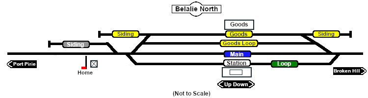
Unmanned station on the  Port Pirie-Broken Hill Line .

Station, goods and passing loops with sidings.

This location was bypassed when the line was converted to standard gauge during 1969-1970.

Line740.png

PortPirie-BrokenHill

Gladstone-Paratoo Strip Map
Personal tools