SAR Belalie North
From TrainzOnline
(Difference between revisions)
m (added height data) |
m |
||
| Line 83: | Line 83: | ||
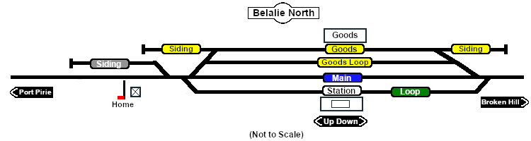
Station, goods and passing loops with sidings. At 621m (2,037ft) '''Belalie North''' was the highest point in all of the '''SAR'''.<br> | Station, goods and passing loops with sidings. At 621m (2,037ft) '''Belalie North''' was the highest point in all of the '''SAR'''.<br> | ||
| − | This location was bypassed when the line was converted to standard gauge during 1969-1970. | + | This location was bypassed in favour of an alignment with easier grades when the line was converted to standard gauge during 1969-1970. |
</td> | </td> | ||
</tr> | </tr> | ||
Revision as of 06:51, 12 November 2021
|
 |