SAR Belalie North
From TrainzOnline
(Difference between revisions)
m |
m |
||
| Line 81: | Line 81: | ||
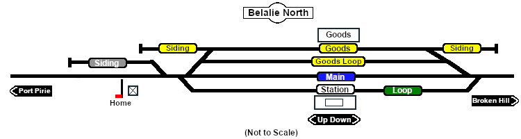
Unmanned station on the <span style="font-weight: 700; color: white; background-color: black;"> Port Pirie-Broken Hill Line </span>.<br> | Unmanned station on the <span style="font-weight: 700; color: white; background-color: black;"> Port Pirie-Broken Hill Line </span>.<br> | ||
| − | Station, goods and passing loops with sidings.<br> | + | Station, goods and passing loops with sidings. '''Belalie North''' was the highest point in the '''SAR''' system.<br> |
This location was bypassed when the line was converted to standard gauge during 1969-1970. | This location was bypassed when the line was converted to standard gauge during 1969-1970. | ||
Revision as of 10:26, 25 December 2020
|
 |