SAR Paratoo V2

From TrainzOnline
Revision as of 01:41, 29 April 2024 by Pware (Talk | contribs)

(diff) ← Older revision | Latest revision (diff) | Newer revision → (diff)
Jump to: navigation, search
Line740.png
Tab HM White.png Tab IN Grey.png Tab TM Grey.png Tab SW Grey.png Tab Blank Grey.png
Line740.png
PortPirie-BrokenHill
Methuen
Location Index
Scenarios
  PortPirie-BrokenHill
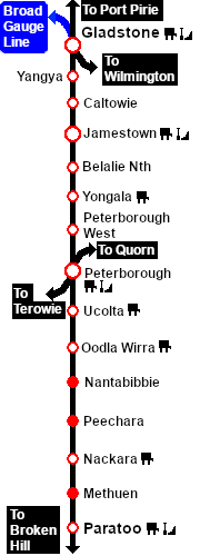
SAR Paratoo V2.png
Map and links updated for SAR Peterborough Narrow Gauge Division v2.0. For the original V1.0 version click here
Line740.png
 Commodities: 
Passengers
Passengers
Station Label.png
Goods
Goods
Goods Label.png
Livestock
Livestock
Stockyard Label.png
   
 Loco Services: 
Coal
Coal
Loco Label.png
Water
Water
Main Label.png
Loop Label.png
 
 Facilities: 
Loop
Loop
Loop Label.png
WYE
Turning
WYE Label.png
   
 Scenario Sessions Starting at Paratoo: 
5 Paratoo-Gladstone Bulk Ore 10 Transcontinental Express Freights

 Distance from Peterborough:  57½ kms, 35¾ miles
Manned station on the  Port Pirie-Broken Hill Line .

Station, crossing and goods loops with a stockyard siding, a loco water/coaling facility and a turning WYE.

Paratoo was the only location on the line with a dedicated signal box.

Broken Hill is 236km (147mi) to the North-East.

After the conversion of the line to standard gauge (4ft8½in - 1435mm) during 1969-1970, all loops, sidings and facilities were removed. There is now little visible evidence of the original narrow gauge railway infrastructure at Paratoo.

Paratoo Yard
Line740.png

PortPirie-BrokenHill

Gladstone-Paratoo Strip Map
Personal tools