Help:Mini Map
From TrainzOnline
(Difference between revisions)
| Line 38: | Line 38: | ||
*Consists | *Consists | ||
| − | Return to [[ | + | Return to [[Help:Surveyor_Main_Menu|TRS19 Surveyor Main Menu]] |
Return to [[Help:TRS2019_Surveyor|TRS19 Surveyor]] | Return to [[Help:TRS2019_Surveyor|TRS19 Surveyor]] | ||
Latest revision as of 16:50, 31 July 2018
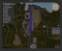
The Mini Map provides a map of your route, and allows you to navigate the route from the 2D map.
[edit]
There are three ways to move around the minimap.
- Use the arrow buttons around the edge of the map
- Right click on a location on the map you want to go to
- Hold the CTRL key, and use the left/right/up/down arrow keys
You can zoom in and out of the map using the following three methods:
- Use the '+' and '-' magnifying glass buttons to zoom in and out respectively in the map window
- Press Page Up and Page Down buttons to zoom in and out respectively.
- Scroll Up and Scroll Down with the mouse wheel to zoom in and out respectively.
You can rotate the map by holding the Shift key and pressing the left and right arrow keys.
[edit] Compass
The compass at the top right corner will show you which way on the route is north.
[edit] Map Display Options
The map display options allow you to turn on and off the following features on the route.
- Map Textures
- Terrain Height Map
- Gradients
- Junctions
- Signals
- Triggers
- Markers
- Crossings
- Trackside Labels
- Terrain Objects
- Industry Names
- Named Objects
- Consists
Return to TRS19 Surveyor Main Menu
Return to TRS19 Surveyor
Return to TRS19 Help Page
