SAR Summit V2
From TrainzOnline
(Difference between revisions)
m |
|||
| (7 intermediate revisions by one user not shown) | |||
| Line 9: | Line 9: | ||
</tr> | </tr> | ||
<tr valign="top"> | <tr valign="top"> | ||
| − | <td align="center">[[image:Tab_HM_White.png|link=]] [[image: | + | <td align="center">[[image:Tab_HM_White.png|link=]] [[image:Tab_IN_Grey.png|link=SAR_Summit_Industry_V2]] [[image:Tab_TM_Grey.png|link=SAR_Summit_Trackmarks_V2]] [[image:Tab_SW_Grey.png|link=SAR_Summit_Switches_V2]] [[image:Tab_Blank_Grey.png|link=]]</td> |
</tr> | </tr> | ||
<tr valign="top"> | <tr valign="top"> | ||
| Line 20: | Line 20: | ||
<tr valign="middle"> | <tr valign="middle"> | ||
<td width=220 align="center">[[Image:SAR_PortAugusta-Hawker_Line.png|link=SAR_Port_Augusta-Hawker_V2|alt=Port Augusta-Hawker|Show Port Augusta-Hawker]]</td> | <td width=220 align="center">[[Image:SAR_PortAugusta-Hawker_Line.png|link=SAR_Port_Augusta-Hawker_V2|alt=Port Augusta-Hawker|Show Port Augusta-Hawker]]</td> | ||
| − | <td width=110 align="right">[[Image:Next Left.png|link=|alt=]]<br>[[Image: | + | <td width=110 align="right">[[Image:Next Left.png|link=|alt=]]<br>[[Image:SAR_Old_Willow_Name.png|link=SAR Old Willow_V2|alt=Old Willow|Next Up Location]]</td> |
<td width=90 align="center">[[Image:Location Index.png|link=SAR Index_V2|alt=Location Index|Location Index]]<br>[[image:Scenario Index.png|link=SAR Peterborough Base Session_V2|alt=Scenarios]]</td> | <td width=90 align="center">[[Image:Location Index.png|link=SAR Index_V2|alt=Location Index|Location Index]]<br>[[image:Scenario Index.png|link=SAR Peterborough Base Session_V2|alt=Scenarios]]</td> | ||
<td width=110 align="left">[[Image:Next Right.png|link=|alt=]]<br>[[Image:SAR_Quorn_W_Name.png|link=SAR Quorn_V2|alt=Quorn|Next Down Location]]</td> | <td width=110 align="left">[[Image:Next Right.png|link=|alt=]]<br>[[Image:SAR_Quorn_W_Name.png|link=SAR Quorn_V2|alt=Quorn|Next Down Location]]</td> | ||
| Line 30: | Line 30: | ||
<table width=750> | <table width=750> | ||
<tr valign="top"> | <tr valign="top"> | ||
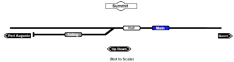
| − | <td>[[image: | + | <td>[[image:SAR_Summit_V2.png|link=|alt=Summit map]]</td> |
</tr> | </tr> | ||
<tr valign="top"> | <tr valign="top"> | ||
| − | <td align="center"><span style="font-weight: 700;">For <span style="color: blue;">SAR Peterborough Narrow Gauge Division v2.0</span></span></td> | + | <td align="center"><span style="font-weight: 700;">For <span style="color: blue;">SAR Peterborough Narrow Gauge Division v2.0</span> only</span></td> |
| + | </tr> | ||
| + | </table> | ||
| + | |||
| + | <table width=750> | ||
| + | <tr valign="top"> | ||
| + | <td align="center">[[Image:line740.png|link=]]</td> | ||
</tr> | </tr> | ||
</table> | </table> | ||
| Line 42: | Line 48: | ||
<td> | <td> | ||
| − | <table width=300 | + | <table width=300> |
<tr valign="top"> | <tr valign="top"> | ||
| − | <td width= | + | <td align="center" width=50>[[Image:Passenger_Icon_off.png|link=|alt=Passengers]]<br><span style="font-size: 10px; font-weight: 700;">Passengers</span><br>[[image:Halt_Label.png|link=]]</td> |
| + | <td align="center" width=200> </td> | ||
</tr> | </tr> | ||
| − | </table | + | </table> |
<table width=175> <!-- BEGIN Loco table (3 items) --> | <table width=175> <!-- BEGIN Loco table (3 items) --> | ||
<tr valign="top"> | <tr valign="top"> | ||
| − | <td align="center" width= | + | <td align="center" width=175> </td> |
</tr> | </tr> | ||
</table> <!-- END Loco table --> | </table> <!-- END Loco table --> | ||
| Line 81: | Line 88: | ||
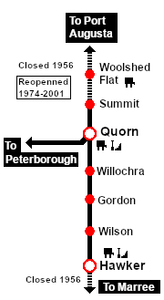
<span style="font-weight: 700;"><span style="color: white; background-color: black;"> Distance from Port Augusta: </span> 32½ kms, 20 miles <span style="color: white; background-color: black;"> Distance from Quorn: </span> 7½ kms, 4½ miles</span><br> | <span style="font-weight: 700;"><span style="color: white; background-color: black;"> Distance from Port Augusta: </span> 32½ kms, 20 miles <span style="color: white; background-color: black;"> Distance from Quorn: </span> 7½ kms, 4½ miles</span><br> | ||
| − | Unmanned location | + | Unmanned location, dead end siding and a passenger '''halt''' on the <span style="font-weight: 700; color: white; background-color: black;"> Port Augusta-Hawker Line </span>. The section from '''Port Augusta''' to '''Quorn''' is now known as the <span style="font-weight: 700; color: white; background-color: black;"> Pichi Richi Railway </span> named after the pass, at '''Summit''', where the railway crosses over the '''Flinders Ranges'''.<br> |
| − | + | True to its name, '''Summit''' is the highest point on the line at 406m (1332ft).<br> | |
| − | + | The line from '''Port Augusta''' to '''Quorn''' was closed in 1956 but the section from '''Quorn''' to '''Summit''' was still in use by passenger excursion trains from '''Peterborough''' in the 1960s. '''Summit''' was used as a terminus with the tour trains running "top and tail" with a loco at both ends for the return trip to '''Quorn'''.<br> | |
| − | </td> | + | |
| + | The '''Pichi Richi Railway''' was formed in 1974 and initially ran tour trains from '''Quorn''' to '''Summit'''. They now operate heritage tourist diesel and steam trains on the fully restored narrow gauge line between '''Quorn''' and '''Port Augusta''' but still use '''Summit''' as a waypoint '''halt''' with the siding used to pass crossing trains.</td> | ||
</tr> | </tr> | ||
Latest revision as of 17:42, 17 September 2024
|
|