File:SAR Orroroo-Quorn Strip Map.png
From TrainzOnline
No higher resolution available.
SAR_Orroroo-Quorn_Strip_Map.png (179 × 400 pixels, file size: 19 KB, MIME type: image/png)
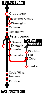
Strip map for the SAR Scenario Quorn-Orroroo
File history
Click on a date/time to view the file as it appeared at that time.
| Date/Time | Thumbnail | Dimensions | User | Comment | |
|---|---|---|---|---|---|
| current | 12:28, 22 November 2022 | | 179 × 400 (19 KB) | Pware (Talk | contribs) | Strip map for the SAR Scenario Quorn-Orroroo |
- Edit this file using an external application (See the [//www.mediawiki.org/wiki/Manual:External_editors setup instructions] for more information)
File usage
There are no pages that link to this file.