|
|
| (6 intermediate revisions by one user not shown) |
| Line 1: |
Line 1: |
| − | <!-- V1.0 and V2.0 versions --> | + | <!-- V1.0 --> |
| − | <!-- V2.0 Stockyard added, new map, industries, track mark, switches, home pages -->
| + | |
| − | <!-- BEGIN V1.0 -->
| + | |
| | <table> | | <table> |
| | <tr valign="top"> | | <tr valign="top"> |
| Line 89: |
Line 87: |
| | Passenger services ended in 1969. The line was closed in 1990 and the track has since been removed.<br> | | Passenger services ended in 1969. The line was closed in 1990 and the track has since been removed.<br> |
| | | | |
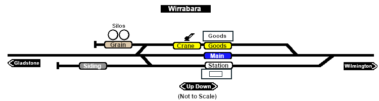
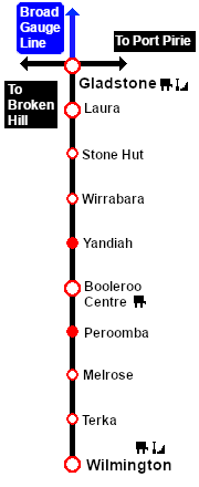
| − | Now only the grain silos remain at the site of the former '''Wirrabara''' station and yard. A short section of track has been preserved at the northern ('''Wilmington''') end of the yard which originally had an '''SAR 7550 Brake Van''' on display but vandalism eventually forced this to be moved to the '''Pichi Richi Railway Preservation Society''' at '''Quorn'''. | + | Now only the grain silos remain at the site of the former '''Wirrabara''' station and yard. A short section of track has been preserved at the northern ('''Wilmington''') end of the yard which originally had an '''SAR 7550 Brake Van''' on display but vandalism eventually forced this to be moved to the '''Pichi Richi Railway Preservation Society''' at '''Quorn'''.<br> |
| − | </td> | + | |
| − | </tr>
| + | |
| | | | |
| − | <tr valign="top">
| + | The former right-of-way from just south of '''Laura''' to '''Wilmington''' is now an 80km walking, cycling and horse riding trail, the '''[https://www.railtrails.org.au/trails/southern-flinders-rail-trail/ Southern Flinders Rail Trail]'''. |
| − | <td align="center">[[Image:line740.png|link=]]</td>
| + | |
| − | </tr>
| + | |
| − | | + | |
| − | </table>
| + | |
| − | | + | |
| − | </td>
| + | |
| − | <td>
| + | |
| − | [[Image:SAR_Gladstone-Wilmington_Line.png|link=SAR_Gladstone_Wilmington|alt=Gladstone-Wilmington|Show Gladstone-Wilmington]]<br>
| + | |
| − | [[Image:SAR_Gladstone-Wilmington Strip Map.png|link=|alt=Gladstone-Wilmington Strip Map]]
| + | |
| − | </td>
| + | |
| − | </tr>
| + | |
| − | </table>
| + | |
| − | | + | |
| − | <!-- END V1.0 -->
| + | |
| − | <!-- BEGIN V2.0
| + | |
| − | | + | |
| − | <table>
| + | |
| − | <tr valign="top">
| + | |
| − | <td width=750>
| + | |
| − | | + | |
| − | <table width=750>
| + | |
| − | <tr valign="top">
| + | |
| − | <td align="center">[[Image:line740.png|link=]]</td>
| + | |
| − | </tr>
| + | |
| − | <tr valign="top">
| + | |
| − | <td align="center">[[image:Tab_HM_White.png|link=]] [[image:Tab_IN_Grey.png|link=SAR_Wirrabara_Industry]] [[image:Tab_TM_Grey.png|link=SAR_Wirrabara_TrackMarks]] [[image:Tab_SW_Grey.png|link=SAR_Wirrabara_Switches]] [[image:Tab_Blank_Grey.png|link=]]</td>
| + | |
| − | </tr>
| + | |
| − | <tr valign="top">
| + | |
| − | <td align="center">[[Image:line740.png|link=]]</td>
| + | |
| − | </tr>
| + | |
| − | </table>
| + | |
| − | | + | |
| − | <table bgcolor="lightgrey" bordercolor="lightgrey" width=750>
| + | |
| − | | + | |
| − | <tr valign="middle">
| + | |
| − | <td width=220 align="right">[[Image:SAR_Gladstone-Wilmington_Line.png|link=SAR Gladstone-Wilmington|alt=Gladstone-Wilmington|Show Gladstone-Wilmington]]</td>
| + | |
| − | <td width=110 align="center">[[Image:Next Left.png|link=|alt=]]<br>[[Image:SAR_Stone_Hut_Name.png|link=SAR Stone Hut|alt=Stone Hut|Next Up Location]]</td>
| + | |
| − | <td width=90 align="center">[[Image:Location Index.png|link=SAR Index|alt=Location Index|Location Index]]<br>[[image:Scenario Index.png|link=SAR Peterborough Base Session|alt=Scenarios]]</td>
| + | |
| − | <td width=110 align="center">[[Image:Next Right.png|link=|alt=]]<br>[[Image:SAR_Yandiah_Name.png|link=SAR Yandiah|alt=Yandiah|Next Down Location]]</td>
| + | |
| − | <td width=220 align="left">[[Image:SAR_Gladstone-Wilmington_Line.png|link=SAR Gladstone-Wilmington|alt=Gladstone-Wilmington|Show Gladstone-Wilmington]]</td>
| + | |
| − | </tr>
| + | |
| − | | + | |
| − | </table>
| + | |
| − | | + | |
| − | <table width=750>
| + | |
| − | <tr valign="top">
| + | |
| − | <td>[[image:SAR_Wirrabara.png|link=|alt=Wirrabara map]]</td>
| + | |
| − | </tr>
| + | |
| − | <tr valign="top">
| + | |
| − | <td align="center"><span style="font-weight: 700;">Map and commodities updated for <span style="color: blue;">SAR Peterborough Narrow Gauge Division v2.0</span></span><br>
| + | |
| − | [[Image:line740.png|link=]]</td>
| + | |
| − | </tr>
| + | |
| − | </table>
| + | |
| − | | + | |
| − | <table bgcolor="lightgrey" bordercolor="lightgrey" width=750>
| + | |
| − | | + | |
| − | <tr valign="top">
| + | |
| − | <td><span style="font-weight: 700; background-color: black; color: white;"> Commodities: </span>
| + | |
| − | | + | |
| − | <table width=300>
| + | |
| − | <tr valign="top">
| + | |
| − | | + | |
| − | <td align="center" width=50>[[Image:Passenger_Icon_off.png|link=|alt=Passengers]]<br><span style="font-size: 10px; font-weight: 700;">Passengers</span><br>[[image:Station_Label.png|link=]]</td>
| + | |
| − | <td align="center" width=50>[[Image:Goods_Icon.png|link=|alt=Goods]]<br><span style="font-size: 10px; font-weight: 700;">Goods</span><br>[[image:Goods_Label.png|link=]]</td>
| + | |
| − | <td align="center" width=50>[[Image:Grain_Icon.png|link=|alt=Grain]]<br><span style="font-size: 10px; font-weight: 700;">Grain</span><br>[[image:Grain_Label.png|link=]]</td>
| + | |
| − | <td align="center" width=50>[[Image:Livestock_Icon.png|link=|alt=Livestock]]<br><span style="font-size: 10px; font-weight: 700;">Livestock</span><br>[[image:Stockyard_Label.png|link=]]</td>
| + | |
| − | <td align="center" width=50> </td>
| + | |
| − | | + | |
| − | </tr>
| + | |
| − | </table>
| + | |
| − | | + | |
| − | </td>
| + | |
| − | <td>
| + | |
| − | | + | |
| − | <table width=175>
| + | |
| − | <tr valign="top">
| + | |
| − | | + | |
| − | <td width=175> </td>
| + | |
| − | | + | |
| − | </tr>
| + | |
| − | </table>
| + | |
| − | | + | |
| − | </td>
| + | |
| − | <td>
| + | |
| − | | + | |
| − | <table width=250>
| + | |
| − | <tr valign="top">
| + | |
| − | | + | |
| − | <td width=250> </td>
| + | |
| − | | + | |
| − | </tr>
| + | |
| − | </table>
| + | |
| − | | + | |
| − | </td>
| + | |
| − | </tr>
| + | |
| − | </table>
| + | |
| − | | + | |
| − | <table width=750>
| + | |
| − | | + | |
| − | <tr valign="top">
| + | |
| − | <td>
| + | |
| − | <span style="font-weight: 700;"><span style="color: white; background-color: black;"> Distance from Gladstone: </span> 29¾ kms, 18½ miles</span><br>
| + | |
| − | | + | |
| − | A manned station on the <span style="font-weight: 700; color: white; background-color: black;"> Gladstone-Wilmington Line </span> until 1983 when all the station staff on the line were withdrawn.<br>
| + | |
| − | | + | |
| − | Station and goods loops, a grain siding and a stockyard siding. A storage shed for bagged grain was also provided.<br>
| + | |
| − | | + | |
| − | The '''Gladstone-Wilmington Line''' is '''unsignalled'''. Train Order working is in operation on the line.<br>
| + | |
| − | | + | |
| − | Passenger services ended in 1969. The line was closed in 1990 and the track has since been removed.<br>
| + | |
| − | | + | |
| − | Now only the grain silos remain at the site of the former '''Wirrabara''' station and yard. A short section of track has been preserved at the northern ('''Wilmington''') end of the yard which originally had an '''SAR 7550 Brake Van''' on display but vandalism eventually forced this to be moved to the '''Pichi Richi Railway Preservation Society''' at '''Quorn'''.
| + | |
| | </td> | | </td> |
| | </tr> | | </tr> |
| Line 222: |
Line 106: |
| | </tr> | | </tr> |
| | </table> | | </table> |
| − |
| |
| − | END V2.0 -->
| |