SAR Peterborough West
From TrainzOnline
(Difference between revisions)
m |
|||
| (2 intermediate revisions by one user not shown) | |||
| Line 28: | Line 28: | ||
</table> <!-- END Location link table with LINE and STATION NAMES --> | </table> <!-- END Location link table with LINE and STATION NAMES --> | ||
| − | [[image:SAR_Peterborough_West.png|link=|alt=Peterborough West map]] | + | <table> |
| + | <tr valign="top"> | ||
| + | <td>[[image:SAR_Peterborough_West.png|link=|alt=Peterborough West map]]</td> | ||
| + | </tr> | ||
| + | <tr valign="top"> | ||
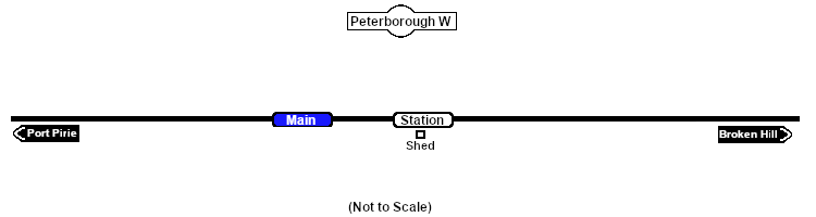
| + | <td align="center"><span style="font-weight: 700;">Peterborough West is a location added to <span style="color: blue;">SAR Peterborough Narrow Gauge Division v2.0</span></span></td> | ||
| + | </tr> | ||
| + | </table> | ||
<table bgcolor="lightgrey" bordercolor="lightgrey" width=750> <!-- BEGIN Location details table --> | <table bgcolor="lightgrey" bordercolor="lightgrey" width=750> <!-- BEGIN Location details table --> | ||
| Line 79: | Line 86: | ||
<span style="font-weight: 700;"><span style="color: white; background-color: black;"> Distance from Gladstone: </span> 64 kms, 39¾ miles <span style="color: white; background-color: black;"> from Peterborough: </span> 1½ kms, 1 mile</span><br> | <span style="font-weight: 700;"><span style="color: white; background-color: black;"> Distance from Gladstone: </span> 64 kms, 39¾ miles <span style="color: white; background-color: black;"> from Peterborough: </span> 1½ kms, 1 mile</span><br> | ||
| − | Unmanned halt on the <span style="font-weight: 700; color: white; background-color: black;"> Port Pirie-Broken Hill Line </span>. | + | Unmanned halt on the <span style="font-weight: 700; color: white; background-color: black;"> Port Pirie-Broken Hill Line </span>. Local passenger services would stop at the request of passengers. |
</td> | </td> | ||
Latest revision as of 07:14, 30 March 2024
|
 |