SAR Paratoo V1

From TrainzOnline
Revision as of 10:23, 31 March 2024 by Pware (Talk | contribs)

(diff) ← Older revision | Latest revision (diff) | Newer revision → (diff)
Jump to: navigation, search
Line740.png
Tab HM White.png Tab IN Grey.png Tab TM Grey.png Tab SW Grey.png Tab Blank Grey.png
Line740.png
PortPirie-BrokenHill
Methuen
Location Index
Scenarios
  PortPirie-BrokenHill
SAR Paratoo V1.png
This is the original v1.0 Paratoo Map and description. For the latest SAR Peterborough Narrow Gauge Division v2.0 version click here. The v2.0 version of the route and sessions requires Trainz Plus or TRS22
 Commodities: 
Passengers
Passengers
Station Label.png
Goods
Goods
Goods Label.png
Livestock
Livestock
Stockyard Label.png
   
 Loco Services: 
Coal
Coal
Loco Label.png
Water
Water
Main Label.png
Loop Label.png
 
 Facilities: 
Loop
Loop
Loop Label.png
WYE
Turning
WYE Label.png
   
 Scenario Sessions Starting at Paratoo: 
5 Paratoo-Gladstone Bulk Ore 10 Transcontinental Express Freights

 Distance from Peterborough:  57½ kms, 35¾ miles
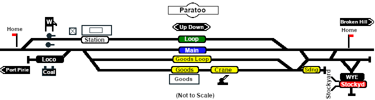
Manned station on the  Port Pirie-Broken Hill Line .

Station, crossing and goods loops with a stockyard siding, a loco water/coaling facility and a turning WYE.

Paratoo was the only location on the line with a dedicated signal box.

Broken Hill is 236km (147mi) to the North-East.

After the conversion of the line to standard gauge (4ft8½in - 1435mm) during 1969-1970, all loops, sidings and facilities were removed. There is now little visible evidence of the original narrow gauge railway infrastructure at Paratoo.

Paratoo Yard
Line740.png

PortPirie-BrokenHill

Gladstone-Paratoo Strip Map
Personal tools