SAR Methuen
From TrainzOnline
(Difference between revisions)
(Created page with "alt=Methuen <br> Main Line with a Passing Loop. Unmanned location on the Peterborough to Paratoo section of the Port Pirie to Broken Hill lin...") |
m |
||
| Line 9: | Line 9: | ||
<tr valign="middle"> | <tr valign="middle"> | ||
<td width=330 align="right">[[Image:SAR_PortPirie-BrokenHill_Line.png|link= |alt=Port Pirie-Broken Hill Line ]][[Image:SAR_Nackara_Name.png|link=SAR Nackara |alt=Nackara |Next Up Location]]</td> | <td width=330 align="right">[[Image:SAR_PortPirie-BrokenHill_Line.png|link= |alt=Port Pirie-Broken Hill Line ]][[Image:SAR_Nackara_Name.png|link=SAR Nackara |alt=Nackara |Next Up Location]]</td> | ||
| − | <td width=90 align="center | + | <td width=90 align="center">[[Image:Location Index.png|link=SAR Index |alt=Location Index |EIT Location Index ]]</td> |
<td width=330 align="left">[[Image:SAR_Paratoo_Name.png|link=SAR Paratoo Down |alt=Paratoo |Next Down Location]]</td> | <td width=330 align="left">[[Image:SAR_Paratoo_Name.png|link=SAR Paratoo Down |alt=Paratoo |Next Down Location]]</td> | ||
</tr> | </tr> | ||
Revision as of 21:28, 4 April 2019
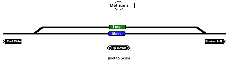
Main Line with a Passing Loop. Unmanned location on the Peterborough to Paratoo section of the Port Pirie to Broken Hill line.
|
 |
|||||||||||||||||||||||||||||||||||||||||||||||||||||||||
