SAR Index V1
From TrainzOnline
(Difference between revisions)
(Created page with "<!-- V1.0 --> <table width=1000> <tr valign="top"> <td align="center" width=800><span style="background-color: blue; color: white; font-weight: 700; font-size: 21px"> SAR...") |
|||
| Line 1: | Line 1: | ||
| − | <!-- V1.0 --> | + | <!-- V1.0 --> |
<table width=1000> | <table width=1000> | ||
<tr valign="top"> | <tr valign="top"> | ||
| − | <td align="center" width=800><span style="background-color: blue; color: white; font-weight: 700; font-size: 21px">& | + | <td align="center" width=800><span style="background-color: blue; color: white; font-weight: 700; font-size: 21px"> SAR Peterborough Narrow Gauge Division </span></td> |
| − | <td width=200>& | + | <td width=200> </td> |
</tr> | </tr> | ||
<tr valign="top"> | <tr valign="top"> | ||
<td align="center"><span style="font-weight: 700; font-size: 15px">Track Diagrams and Location Data</span></td> | <td align="center"><span style="font-weight: 700; font-size: 15px">Track Diagrams and Location Data</span></td> | ||
| − | <td>& | + | <td> </td> |
</tr> | </tr> | ||
<tr valign="top"> | <tr valign="top"> | ||
| − | <td align="center">[[Image:Location Index.png|link=|alt=Location Index]]<br>'''All links will open in this window'''</td> | + | <td align="center">[[Image:Location Index.png|link=|alt=Location Index]]<br> |
| − | <td align="center">[[image:Session Scenario Index.png|link=SAR Peterborough Base Session|alt=Scenarios]]& | + | '''All links will open in this window'''</td> |
| + | <td align="center">[[image:Session Scenario Index.png|link=SAR Peterborough Base Session V1|alt=Scenarios]] [[image:SAR Tutorial.png|link=SAR Scenarios Tutorial V1|alt=Tutorial]]</td> | ||
</tr> | </tr> | ||
</table> | </table> | ||
| + | |||
<table width=1000> | <table width=1000> | ||
<tr valign="top"> | <tr valign="top"> | ||
<td width=800> | <td width=800> | ||
<table> | <table> | ||
| − | <tr valign="middle> | + | <tr valign="middle"> |
| − | <td>[[Image:SAR_PortPirie-BrokenHill_Line.png|link=SAR Port Pirie-Broken Hill|alt=Port Pirie-Broken Hill Line|Show Port Pirie-Broken Hill Line]]& | + | <td>[[Image:SAR_PortPirie-BrokenHill_Line.png|link=SAR Port Pirie-Broken Hill V1|alt=Port Pirie-Broken Hill Line|Show Port Pirie-Broken Hill Line]] </td> |
| − | <td><span style="font-weight: 700; background-color: black; color: white;">& | + | <td><span style="font-weight: 700; background-color: black; color: white;"> 127km - 79mi </span></td> |
<td><span style="font-weight: 700;">Gladstone to Paratoo Section</span></td> | <td><span style="font-weight: 700;">Gladstone to Paratoo Section</span></td> | ||
</tr> | </tr> | ||
| Line 26: | Line 28: | ||
<table bgcolor="lightYellow"> | <table bgcolor="lightYellow"> | ||
<tr valign="top"> | <tr valign="top"> | ||
| − | <td width=150>'''[[SAR Gladstone|Gladstone]]'''& | + | <td width=150>'''[[SAR Gladstone V1|Gladstone]]''' [[image:JunctionDot.png|link=]]</td> |
| − | <td width=10>& | + | <td width=10> </td> |
| − | <td width=150>'''[[SAR Yangya|Yangya]]'''</td> | + | <td width=150>'''[[SAR Yangya V1|Yangya]]'''</td> |
| − | <td width=10>& | + | <td width=10> </td> |
| − | <td width=150>'''[[SAR Caltowie|Caltowie]]'''</td> | + | <td width=150>'''[[SAR Caltowie V1|Caltowie]]'''</td> |
| − | <td width=10>& | + | <td width=10> </td> |
| − | <td width=150>'''[[SAR Jamestown|Jamestown]]'''</td> | + | <td width=150>'''[[SAR Jamestown V1|Jamestown]]'''</td> |
| − | <td width=10>& | + | <td width=10> </td> |
| − | <td width=150>'''[[SAR Belalie North|Belalie North]]'''</td> | + | <td width=150>'''[[SAR Belalie North V1|Belalie North]]'''</td> |
</tr> | </tr> | ||
<tr valign="top"> | <tr valign="top"> | ||
| − | <td>'''[[SAR Yongala|Yongala]]'''</td> | + | <td>'''[[SAR Yongala V1|Yongala]]'''</td> |
| − | <td>& | + | <td> </td> |
| − | <td>'''[[SAR Peterborough|Peterborough]]'''& | + | <td>'''[[SAR Peterborough V1|Peterborough]]''' [[image:JunctionDot.png|link=]]</td> |
| − | <td>& | + | <td> </td> |
| − | <td>'''[[SAR Ucolta|Ucolta]]'''</td> | + | <td>'''[[SAR Ucolta V1|Ucolta]]'''</td> |
| − | <td>& | + | <td> </td> |
| − | <td>'''[[SAR Oodla Wirra|Oodla Wirra]]'''</td> | + | <td>'''[[SAR Oodla Wirra V1|Oodla Wirra]]'''</td> |
| − | <td>& | + | <td> </td> |
| − | <td>'''[[SAR Nantabibbie|Nantabibbie]]'''</td> | + | <td>'''[[SAR Nantabibbie V1|Nantabibbie]]'''</td> |
</tr> | </tr> | ||
<tr valign="top"> | <tr valign="top"> | ||
| − | <td>'''[[SAR Peechara|Peechara]]'''</td> | + | <td>'''[[SAR Peechara V1|Peechara]]'''</td> |
| − | <td>& | + | <td> </td> |
| − | <td>'''[[SAR Nackara|Nackara]]'''</td> | + | <td>'''[[SAR Nackara V1|Nackara]]'''</td> |
| − | <td>& | + | <td> </td> |
| − | <td>'''[[SAR Methuen|Methuen]]'''</td> | + | <td>'''[[SAR Methuen V1|Methuen]]'''</td> |
| − | <td>& | + | <td> </td> |
| − | <td>'''[[SAR Paratoo|Paratoo]]'''</td> | + | <td>'''[[SAR Paratoo V1|Paratoo]]'''</td> |
</tr> | </tr> | ||
</table> | </table> | ||
<table> | <table> | ||
| − | <tr valign="middle> | + | <tr valign="middle"> |
| − | <td>[[Image:SAR_Peterborough-Terowie_Line.png|link=SAR Peterborough-Terowie|alt=Peterborough-Terowie Line|Show Peterborough-Terowie Line]]& | + | <td>[[Image:SAR_Peterborough-Terowie_Line.png|link=SAR Peterborough-Terowie V1|alt=Peterborough-Terowie Line|Show Peterborough-Terowie Line]] </td> |
| − | <td><span style="font-weight: 700; background-color: black; color: white;">& | + | <td><span style="font-weight: 700; background-color: black; color: white;"> 23km - 14mi </span></td> |
</tr> | </tr> | ||
</table> | </table> | ||
<table bgcolor="lightYellow"> | <table bgcolor="lightYellow"> | ||
<tr valign="top"> | <tr valign="top"> | ||
| − | <td width=150>'''[[SAR Peterborough|Peterborough]]'''& | + | <td width=150>'''[[SAR Peterborough V1|Peterborough]]''' [[image:JunctionDot.png|link=]]</td> |
| − | <td width=10>& | + | <td width=10> </td> |
| − | <td width=150>'''[[SAR Gumbowie|Gumbowie]]'''</td> | + | <td width=150>'''[[SAR Gumbowie V1|Gumbowie]]'''</td> |
| − | <td width=10>& | + | <td width=10> </td> |
| − | <td width=480>'''[[SAR Terowie|Terowie]]'''& | + | <td width=480>'''[[SAR Terowie V1|Terowie]]''' [[image:JunctionDot.png|link=]] [[image:TerminalDot.png|link=]]</td> |
</tr> | </tr> | ||
</table> | </table> | ||
<table> | <table> | ||
<tr valign="middle"> | <tr valign="middle"> | ||
| − | <td>[[Image:SAR_Peterborough-Quorn_Line.png|link=SAR Peterborough-Quorn|alt=Port Peterborough-Quorn Line|Show Peterborough-Quorn Line]]& | + | <td>[[Image:SAR_Peterborough-Quorn_Line.png|link=SAR Peterborough-Quorn V1|alt=Port Peterborough-Quorn Line|Show Peterborough-Quorn Line]] </td> |
| − | <td><span style="font-weight: 700; background-color: black; color: white;">& | + | <td><span style="font-weight: 700; background-color: black; color: white;"> 137km - 85mi </span></td> |
</tr> | </tr> | ||
</table> | </table> | ||
<table bgcolor="lightYellow"> | <table bgcolor="lightYellow"> | ||
<tr valign="top"> | <tr valign="top"> | ||
| − | <td width=150>'''[[SAR Peterborough|Peterborough]]'''& | + | <td width=150>'''[[SAR Peterborough V1|Peterborough]]''' [[image:JunctionDot.png|link=]]</td> |
| − | <td width=10>& | + | <td width=10> </td> |
| − | <td width=150>'''[[SAR Minvalara|Minvalara]]'''</td> | + | <td width=150>'''[[SAR Minvalara V1|Minvalara]]'''</td> |
| − | <td width=10>& | + | <td width=10> </td> |
| − | <td width=150>'''[[SAR Black Rock|Black Rock]]'''</td> | + | <td width=150>'''[[SAR Black Rock V1|Black Rock]]'''</td> |
| − | <td width=10>& | + | <td width=10> </td> |
| − | <td width=150>'''[[SAR Orroroo|Orroroo]]'''</td> | + | <td width=150>'''[[SAR Orroroo V1|Orroroo]]'''</td> |
| − | <td width=10>& | + | <td width=10> </td> |
| − | <td width=150>'''[[SAR Wallaway|Wallaway]]'''</td> | + | <td width=150>'''[[SAR Wallaway V1|Wallaway]]'''</td> |
</tr> | </tr> | ||
<tr valign="top"> | <tr valign="top"> | ||
| − | <td>'''[[SAR Halls Well|Halls Well]]'''</td> | + | <td>'''[[SAR Halls Well V1|Halls Well]]'''</td> |
| − | <td>& | + | <td> </td> |
| − | <td>'''[[SAR Eurelia|Eurelia]]'''</td> | + | <td>'''[[SAR Eurelia V1|Eurelia]]'''</td> |
| − | <td>& | + | <td> </td> |
| − | <td>'''[[SAR Carrieton|Carrieton]]'''</td> | + | <td>'''[[SAR Carrieton V1|Carrieton]]'''</td> |
| − | <td>& | + | <td> </td> |
| − | <td>'''[[SAR Moockra|Moockra]]</td> | + | <td>'''[[SAR Moockra V1|Moockra]]</td> |
| − | <td>& | + | <td> </td> |
| − | <td>'''[[SAR Hammond|Hammond]]'''</td> | + | <td>'''[[SAR Hammond V1|Hammond]]'''</td> |
</tr> | </tr> | ||
<tr valign="top"> | <tr valign="top"> | ||
| − | <td>'''[[SAR Bruce|Bruce]]'''</td> | + | <td>'''[[SAR Bruce V1|Bruce]]'''</td> |
| − | <td>& | + | <td> </td> |
| − | <td>'''[[SAR Kingswood|Kingswood]]'''</td> | + | <td>'''[[SAR Kingswood V1|Kingswood]]'''</td> |
| − | <td>& | + | <td> </td> |
| − | <td>'''[[SAR Quorn|Quorn]]'''& | + | <td>'''[[SAR Quorn V1|Quorn]]''' [[image:JunctionDot.png|link=]]</td> |
| − | <td>& | + | <td> </td> |
</tr> | </tr> | ||
</table> | </table> | ||
<table> | <table> | ||
<tr valign="middle"> | <tr valign="middle"> | ||
| − | <td>[[Image:SAR_Gladstone-Wilmington_Line.png|link=SAR Gladstone-Wilmington|alt=SAR Gladstone-Wilmington Line|Show Gladstone-Wilmington Line]]& | + | <td>[[Image:SAR_Gladstone-Wilmington_Line.png|link=SAR Gladstone-Wilmington V1|alt=SAR Gladstone-Wilmington Line|Show Gladstone-Wilmington Line]] </td> |
| − | <td><span style="font-weight: 700; background-color: black; color: white;">& | + | <td><span style="font-weight: 700; background-color: black; color: white;"> 88km - 54mi </span></td> |
</tr> | </tr> | ||
</table> | </table> | ||
<table bgcolor="lightYellow"> | <table bgcolor="lightYellow"> | ||
<tr valign="top"> | <tr valign="top"> | ||
| − | <td width=150>'''[[SAR Gladstone|Gladstone]]'''& | + | <td width=150>'''[[SAR Gladstone V1|Gladstone]]''' [[image:JunctionDot.png|link=]]</td> |
| − | <td width=10>& | + | <td width=10> </td> |
| − | <td width=150>'''[[SAR Laura|Laura]]'''</td> | + | <td width=150>'''[[SAR Laura V1|Laura]]'''</td> |
| − | <td width=10>& | + | <td width=10> </td> |
| − | <td width=150>'''[[SAR Stone Hut|Stone Hut]]'''</td> | + | <td width=150>'''[[SAR Stone Hut V1|Stone Hut]]'''</td> |
| − | <td width=10>& | + | <td width=10> </td> |
| − | <td width=150>'''[[SAR Wirrabara|Wirrabara]]'''</td> | + | <td width=150>'''[[SAR Wirrabara V1|Wirrabara]]'''</td> |
| − | <td width=10>& | + | <td width=10> </td> |
| − | <td width=150>'''[[SAR Yandiah|Yandiah]]'''</td> | + | <td width=150>'''[[SAR Yandiah V1|Yandiah]]'''</td> |
</tr> | </tr> | ||
<tr valign="top"> | <tr valign="top"> | ||
| − | <td>'''[[SAR Booleroo Centre|Booleroo Centre]]'''</td> | + | <td>'''[[SAR Booleroo Centre V1|Booleroo Centre]]'''</td> |
| − | <td>& | + | <td> </td> |
| − | <td>'''[[SAR Peroomba|Peroomba]]'''</td> | + | <td>'''[[SAR Peroomba V1|Peroomba]]'''</td> |
| − | <td>& | + | <td> </td> |
| − | <td>'''[[SAR Melrose|Melrose]]'''</td> | + | <td>'''[[SAR Melrose V1|Melrose]]'''</td> |
| − | <td>& | + | <td> </td> |
| − | <td>'''[[SAR Terka|Terka]]'''</td> | + | <td>'''[[SAR Terka V1|Terka]]'''</td> |
| − | <td>& | + | <td> </td> |
| − | <td>'''[[SAR Wilmington|Wilmington]]'''& | + | <td>'''[[SAR Wilmington V1|Wilmington]]''' [[image:TerminalDot.png|link=]]</td> |
</tr> | </tr> | ||
<tr align="top"> | <tr align="top"> | ||
| − | <td align="center" colspan=9>[[image:JunctionDot.png|link=]]& | + | <td align="center" colspan=9>[[image:JunctionDot.png|link=]] '''Junction''' [[image:TerminalDot.png|link=]] '''Terminus'''</td> |
</tr> | </tr> | ||
</table> | </table> | ||
</td> | </td> | ||
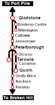
<td align="center" width=200>[[image:SAR Nth Division Strip Map.png|link=|alt=SAR Northern Division Map]]</td> | <td align="center" width=200>[[image:SAR Nth Division Strip Map.png|link=|alt=SAR Northern Division Map]]</td> | ||
| + | </tr> | ||
| + | </table> | ||
| + | |||
| + | <table width=1000> | ||
| + | <tr valign="top"> | ||
| + | <td><span style="font-weight: 700;">This is the original <span style="color: blue;">V1.0 Index</span>. For the latest <span style="color: blue;">SAR Peterborough Narrow Gauge Division V2.0 Index</span> click <span style="background-color: yellow;">[[SAR_Index_V2|here]]</span>. The V2.0 version of the route and sessions requires Trainz Plus or TRS22</span></td> | ||
</tr> | </tr> | ||
</table> | </table> | ||
Revision as of 10:24, 25 April 2024
| SAR Peterborough Narrow Gauge Division | |
| Track Diagrams and Location Data | |
 All links will open in this window |
  |
|
 |
||||||||||||||||||||||||||||||||||||||||||||||||||||||||||||||||||||||||||||||||||||||||||
| This is the original V1.0 Index. For the latest SAR Peterborough Narrow Gauge Division V2.0 Index click here. The V2.0 version of the route and sessions requires Trainz Plus or TRS22 |