From TrainzOnline
(Difference between revisions)
|
|
| Line 33: |
Line 33: |
| | </tr> | | </tr> |
| | <tr valign="top"> | | <tr valign="top"> |
| − | <td align="center"><span style="font-weight: 700;">Links updated for <span style="color: blue;">SAR Peterborough Narrow Gauge Division v2.0</span>. For the original <span style="color: blue;">V1.0</span> version click <span style="background-color: yellow;">[[SAR_Gumbowie_V1|here]]</span></span><br> | + | <td align="center"><span style="font-weight: 700;">For <span style="color: blue;">SAR Peterborough Narrow Gauge Division v2.0</span>. For the original <span style="color: blue;">V1.0</span> click <span style="background-color: yellow;">[[SAR_Gumbowie_V1|here]]</span></span></td> |
| − | <span style="font-weight: 700;">V2.0 requires Trainz Plus or TRS22 to run</span><br> | + | </tr> |
| − | [[Image:line740.png|link=]]</td> | + | </table> |
| | + | |
| | + | <table width=750> |
| | + | <tr valign="top"> |
| | + | <td align="center">[[Image:line740.png|link=]]</td> |
| | </tr> | | </tr> |
| | </table> | | </table> |
Latest revision as of 21:51, 30 April 2024
 |
| For SAR Peterborough Narrow Gauge Division v2.0. For the original V1.0 click here |
|
|
|
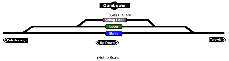
Facilities:

Loop
 |
|
|
|
|
|
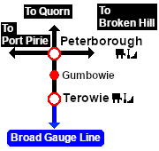
Distance from Terowie: 21¾ kms, 13½ miles from Peterborough: 11¼ kms, 7 miles
Unmanned location on the Peterborough-Terowie Line .
Crossing and siding loops.
A signal box and a small station building that were originally present on the main line had been removed by the start of the 1960s. After Belalie North was bypassed by the gauge conversion (1969-70) Gumbowie at 610m (2001ft) became the highest point in the SAR system.
The main line and crossing loop were converted to dual gauge with the addition of a broad gauge (5ft3in - 1600mm) track to the existing narrow gauge (3ft6in - 1067mm) main line and loop in 1970 but the siding remained narrow gauge only. The Peterborough-Terowie Line was closed in 1988.
Today nothing remains at Gumbowie to indicate that it was once a railway location.
|
 |
|

 |
