SAR Carrieton V1
(Created page with "<!-- V1.0 --> <table> <!-- BEGIN TOP TABLE --> <tr valign="top"> <td width=750> <table width=750> <!-- BEGIN TABBED link list with Home page active--> <tr valign="top"> <td...") |
m |
||
| Line 1: | Line 1: | ||
<!-- V1.0 --> | <!-- V1.0 --> | ||
| − | <table> <!-- BEGIN TOP TABLE --> | + | <table width=1000> <!-- BEGIN TOP TABLE --> |
<tr valign="top"> | <tr valign="top"> | ||
<td width=750> | <td width=750> | ||
| Line 9: | Line 9: | ||
</tr> | </tr> | ||
<tr valign="top"> | <tr valign="top"> | ||
| − | <td align="center">[[image:Tab_HM_White.png|link=]] [[image:Tab_IN_Grey.png|link= | + | <td align="center">[[image:Tab_HM_White.png|link=]] [[image:Tab_IN_Grey.png|link=SAR_Carrieton_Industry_V1]] [[image:Tab_TM_Grey.png|link=SAR_Carrieton_TrackMarks_V1]] [[image:Tab_SW_Grey.png|link=SAR_Carrieton_Switches_V1]] [[image:Tab_Blank_Grey.png|link=]]</td> |
</tr> | </tr> | ||
<tr valign="top"> | <tr valign="top"> | ||
| Line 19: | Line 19: | ||
<tr valign="middle"> | <tr valign="middle"> | ||
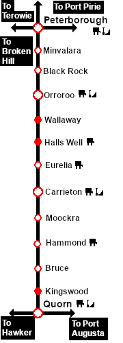
| − | <td width=220 align="right">[[Image:SAR_Peterborough-Quorn_Line.png|link=SAR Peterborough- | + | <td width=220 align="right">[[Image:SAR_Peterborough-Quorn_Line.png|link=SAR Peterborough-Quorn_V1|alt=Peterborough-Quorn|Show Peterborough-Quorn]]</td> |
| − | <td width=110 align="center">[[Image:Next Left.png|link=|alt=]]<br>[[Image:SAR_Eurelia_Name.png|link=SAR | + | <td width=110 align="center">[[Image:Next Left.png|link=|alt=]]<br>[[Image:SAR_Eurelia_Name.png|link=SAR Eurelia_V1|alt=Eurelia|Next Up Location]]</td> |
| − | <td width=90 align="center">[[Image:Location Index.png|link=SAR | + | <td width=90 align="center">[[Image:Location Index.png|link=SAR Index_V1|alt=Location Index|Location Index]]<br>[[image:Scenario Index.png|link=SAR Peterborough Base Session_V1|alt=Scenarios|Scenario Index]]</td> |
| − | <td width=110 align="center">[[Image:Next Right.png|link=|alt=]]<br>[[Image:SAR_Moockra_Name.png|link=SAR | + | <td width=110 align="center">[[Image:Next Right.png|link=|alt=]]<br>[[Image:SAR_Moockra_Name.png|link=SAR Moockra_V1||alt=Moockra|Next Down Location]]</td> |
| − | <td width=220 align="left">[[Image:SAR_Peterborough-Quorn_Line.png|link=SAR Peterborough- | + | <td width=220 align="left">[[Image:SAR_Peterborough-Quorn_Line.png|link=SAR Peterborough-Quorn_V1|alt=Peterborough-Quorn|Show Peterborough-Quorn]]</td> |
</tr> | </tr> | ||
| Line 33: | Line 33: | ||
</tr> | </tr> | ||
<tr valign="top"> | <tr valign="top"> | ||
| − | <td align="center"><span style="font-weight: 700;"> | + | <td align="center"><span style="font-weight: 700;">For <span style="color: blue;">SAR Peterborough Narrow Gauge Division v1.0</span>. For the latest <span style="color: blue;">V2.0</span> click <span style="background-color: yellow;">[[SAR_Carrieton_V2|here]]</span></span></td> |
| − | [[Image:line740.png|link=]]</td> | + | </tr> |
| + | </table> | ||
| + | |||
| + | <table width=750> | ||
| + | <tr valign="top"> | ||
| + | <td align="center">[[Image:line740.png|link=]]</td> | ||
</tr> | </tr> | ||
</table> | </table> | ||
| Line 114: | Line 119: | ||
</td> | </td> | ||
<td> | <td> | ||
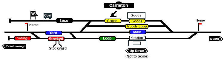
| − | [[Image:SAR_Peterborough-Quorn_Line.png|link=SAR_Peterborough- | + | [[Image:SAR_Peterborough-Quorn_Line.png|link=SAR_Peterborough-Quorn_V1|alt=Peterborough-Quorn|Show Peterborough-Quorn]]<br> |
[[Image:SAR_Peterborough-Quorn Strip Map.png|link=|alt=Peterborough-Quorn Strip Map]]</td> | [[Image:SAR_Peterborough-Quorn Strip Map.png|link=|alt=Peterborough-Quorn Strip Map]]</td> | ||
</tr> | </tr> | ||
</table> <!-- END TOP TABLE --> | </table> <!-- END TOP TABLE --> | ||
Latest revision as of 20:39, 2 May 2024
|
 |