SAR Black Rock
From TrainzOnline
(Difference between revisions)
(Home page for Black Rock) |
m |
||
| (19 intermediate revisions by one user not shown) | |||
| Line 5: | Line 5: | ||
<table width=750> <!-- BEGIN TABBED link list with Home page active--> | <table width=750> <!-- BEGIN TABBED link list with Home page active--> | ||
<tr valign="top"> | <tr valign="top"> | ||
| − | <td | + | <td align="center">[[Image:line740.png|link=]]</td> |
</tr> | </tr> | ||
<tr valign="top"> | <tr valign="top"> | ||
| − | + | <td align="center">[[image:Tab_HM_White.png|link=]] [[image:Tab_IN_Grey.png|link=SAR_Black Rock_Industry]] [[image:Tab_TM_Grey.png|link=SAR_Black Rock_TrackMarks]] [[image:Tab_SW_Grey.png|link=SAR_Black Rock_Switches]] [[image:Tab_Blank_Grey.png|link=]]</td> | |
| − | <td align=" | + | |
| − | + | ||
</tr> | </tr> | ||
<tr valign="top"> | <tr valign="top"> | ||
| − | <td | + | <td align="center">[[Image:line740.png|link=]]</td> |
</tr> | </tr> | ||
</table> <!-- END TABBED link list --> | </table> <!-- END TABBED link list --> | ||
| − | <table bgcolor="lightgrey" bordercolor="lightgrey" width=750> <!-- BEGIN Location | + | <table bgcolor="lightgrey" bordercolor="lightgrey" width=750> <!-- BEGIN Location link table with LINE and STATION NAMES --> |
<tr valign="middle"> | <tr valign="middle"> | ||
<td width=220 align="right">[[Image:SAR_Peterborough-Quorn_Line.png|link=SAR Peterborough-Quorn|alt=Peterborough-Quorn|Show Peterborough-Quorn]]</td> | <td width=220 align="right">[[Image:SAR_Peterborough-Quorn_Line.png|link=SAR Peterborough-Quorn|alt=Peterborough-Quorn|Show Peterborough-Quorn]]</td> | ||
<td width=110 align="center">[[Image:Next Left.png|link=|alt=]]<br>[[Image:SAR_Minvalara_Name.png|link=SAR Minvalara|alt=Minvalara|Next Up Location]]</td> | <td width=110 align="center">[[Image:Next Left.png|link=|alt=]]<br>[[Image:SAR_Minvalara_Name.png|link=SAR Minvalara|alt=Minvalara|Next Up Location]]</td> | ||
| − | <td width=90 align="center">[[Image:Location Index.png|link=SAR Index|alt=Location Index| | + | <td width=90 align="center">[[Image:Location Index.png|link=SAR Index|alt=Location Index|Location Index]]<br>[[image:Scenario Index.png|link=SAR Peterborough Base Session|alt=Scenarios|Scenario Index]]</td> |
<td width=110 align="center">[[Image:Next Right.png|link=|alt=]]<br>[[Image:SAR_Orroroo_Name.png|link=SAR Orroroo|alt=Orooro|Next Down Location]]</td> | <td width=110 align="center">[[Image:Next Right.png|link=|alt=]]<br>[[Image:SAR_Orroroo_Name.png|link=SAR Orroroo|alt=Orooro|Next Down Location]]</td> | ||
<td width=220 align="left">[[Image:SAR_Peterborough-Quorn_Line.png|link=SAR Peterborough-Quorn|alt=Peterborough-Quorn|Show Peterborough-Quorn]]</td> | <td width=220 align="left">[[Image:SAR_Peterborough-Quorn_Line.png|link=SAR Peterborough-Quorn|alt=Peterborough-Quorn|Show Peterborough-Quorn]]</td> | ||
</tr> | </tr> | ||
| + | |||
| + | </table> <!-- END Location link table with LINE and STATION NAMES --> | ||
| + | |||
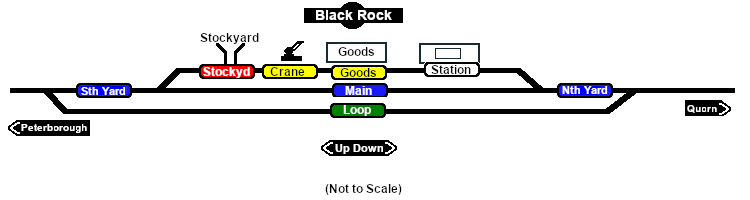
| + | [[Image:SAR_Black Rock.png|link=|alt=Black Rock Diagram]]<br> <!-- Map --> | ||
| + | |||
| + | <table bgcolor="lightgrey" bordercolor="lightgrey" width=750> <!-- BEGIN Location details table --> | ||
| + | |||
<tr valign="top"> | <tr valign="top"> | ||
| − | <td | + | <td><span style="font-weight: 700; background-color: black; color: white;"> Commodities: </span> |
| − | <table> <!-- BEGIN Commodities | + | <table width=300> <!-- BEGIN Commodities table (5 items) --> |
<tr valign="top"> | <tr valign="top"> | ||
| − | <td align="center">[[Image: | + | |
| − | <td align="center">[[Image:Goods_Icon.png|link=|alt=Goods]]<br><span style="font-size: 10px; font-weight: 700;">Goods</span><br>[[image:Goods_Label.png|link=]]</td> | + | <td align="center" width=50>[[Image:Passenger_Icon_off.png|link=|alt=Passengers]]<br><span style="font-size: 10px; font-weight: 700;">Passengers</span><br>[[image:Station_Label.png|link=]]</td> |
| − | <td align="center">[[Image:Livestock_Icon.png|link=|alt=Livestock]]<br><span style="font-size: 10px; font-weight: 700;">Livestock</span><br>[[image:Stockyard_Label.png|link=]]</td> | + | <td align="center" width=50>[[Image:Goods_Icon.png|link=|alt=Goods]]<br><span style="font-size: 10px; font-weight: 700;">Goods</span><br>[[image:Goods_Label.png|link=]]</td> |
| + | <td align="center" width=50>[[Image:Livestock_Icon.png|link=|alt=Livestock]]<br><span style="font-size: 10px; font-weight: 700;">Livestock</span><br>[[image:Stockyard_Label.png|link=]]</td> | ||
| + | <td align="center" width=50> </td> <!-- holding space 4 --> | ||
| + | <td align="center" width=50> </td> <!-- holding space 5 --> | ||
| + | |||
</tr> | </tr> | ||
| − | </table> | + | </table> <!-- END Commodities Table --> |
</td> | </td> | ||
| − | <td | + | <td> |
| − | <table> <!-- BEGIN | + | <table width=175> <!-- BEGIN Loco table (3 items) --> |
<tr valign="top"> | <tr valign="top"> | ||
| − | <td | + | |
| + | <td width=175> </td> <!-- holding space 1-3 for no Loco items - REMOVE black background and "Loco Serices" label --> | ||
| + | |||
</tr> | </tr> | ||
| − | </table> | + | </table> <!-- END Loco table --> |
</td> | </td> | ||
| + | <td><span style="font-weight: 700;"><span style="background-color: black; color: white;"> Facilities: </span></span> | ||
| + | |||
| + | <table width=250> <!-- BEGIN Facilities table (4 items) --> | ||
| + | <tr valign="top"> | ||
| + | |||
| + | <td align="center" width=50>[[Image:Loop_Icon.png|link=|alt=Loop]]<br><span style="font-size: 10px; font-weight: 700;">Loop</span><br>[[image:Loop_Label.png|link=]]</td> | ||
| + | <td align="center" width=50> </td> <!-- holding space 2 --> | ||
| + | <td align="center" width=50> </td> <!-- holding space 3 --> | ||
| + | <td align="center" width=50> </td> <!-- holding space 4 --> | ||
| + | |||
</tr> | </tr> | ||
| + | </table> <!-- END Facilities Table --> | ||
| + | </td> | ||
| + | </tr> | ||
</table> <!-- END Location details table --> | </table> <!-- END Location details table --> | ||
| Line 55: | Line 79: | ||
<tr valign="top"> | <tr valign="top"> | ||
<td width=750> | <td width=750> | ||
| − | + | <span style="font-weight: 700;"><span style="color: white; background-color: black;"> Distance from Peterborough: </span> 22 kms, 13¾ miles</span><br> | |
| + | |||
| + | Unmanned station on the <span style="font-weight: 700; color: white; background-color: black;"> Peterborough-Quorn Line </span>.<br> | ||
| + | |||
| + | Crossing loop and a station/goods/stockyard loop.<br> | ||
| + | |||
| + | The most notable and most photographed feature of '''Black Rock''' is the '''Black Rock Bridge''' about 2kms south (towards '''Peterborough'''). It is only a few metres in height above a flood plain but at 241 m (792 ft) long it is the longest bridge in the Division.<br> | ||
| + | |||
| + | The line from '''Peterborough''' to '''Eurelia''' was closed to normal traffic in 1988 and was fully closed in 2002. Most of the track was removed in 2008. '''Black Rock''' station yard and '''Black Rock Bridge''' are two of the few places on the line where the track has been preserved. | ||
</td> | </td> | ||
</tr> | </tr> | ||
| Line 67: | Line 99: | ||
</td> | </td> | ||
<td> | <td> | ||
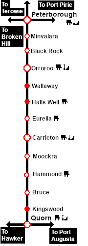
| + | [[Image:SAR_Peterborough-Quorn_Line.png|link=SAR Peterborough-Quorn|alt=Peterborough-Quorn|Show Peterborough-Quorn]]<br> | ||
[[Image:SAR_Peterborough-Quorn Strip Map.png|link=|alt=Peterborough-Quorn Strip Map]]</td> | [[Image:SAR_Peterborough-Quorn Strip Map.png|link=|alt=Peterborough-Quorn Strip Map]]</td> | ||
</tr> | </tr> | ||
</table> <!-- END TOP TABLE --> | </table> <!-- END TOP TABLE --> | ||
Latest revision as of 17:15, 26 September 2022
|
 |