The information in this Wiki Page applies to TANE, TRS19, Trainz Plus and TRS22.
|
|
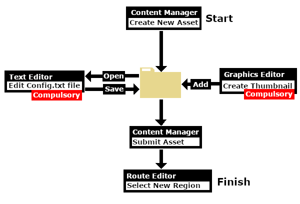
Workflow Diagram
 |
What is a Region?
 |
A Region defines some of the characteristics of a geographic location (e.g. a country or a province) that is represented in a route |
|
A Region Asset is just a config.txt file (plus a thumbnail) that contains all the data for a region |
How to Create a Region Asset
| Steps: |
 Create the Asset: Create the Asset:
 |
| Steps: From the Trainz Launcher:- |
| 1 |
select Manage Content |
| 2 |
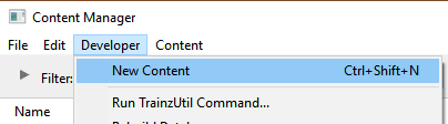
in Content Manager open the Developer menu |
| 3 |
select New Content
 |
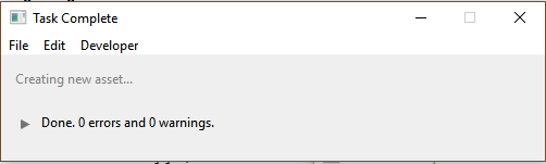
This will create a new asset and open it for editing. |
|
A message window will appear that will (hopefully) report on the successful creation of a new asset |
|
| 4 |
Close the message window |
|
|
|
| |
 Find the New Asset: Find the New Asset:
 |
| 5 |
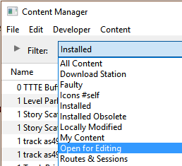
Set the Content Manager Search Filter to Open for Editing |
| This will display only those assets that have been opened for editing (hopefully only your new and as yet unnamed asset will be shown) |
|
|
|
| |
 Open the Asset in Windows File Explorer: Open the Asset in Windows File Explorer:
 |
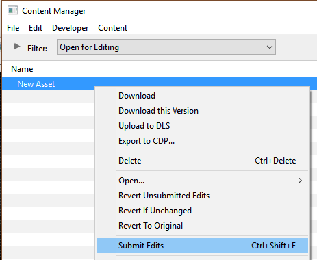
| 6 |
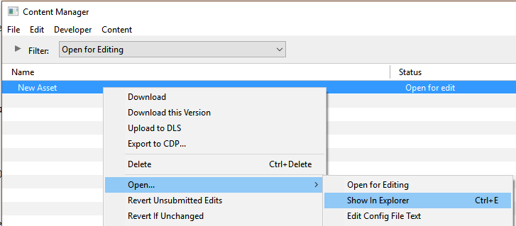
Right Click on the entry New Asset |
| 7 |
Select Open... |
| 8 |
Select Show in Explorer |
|
|
|
| |
 Open Config.txt File in Notepad: Open Config.txt File in Notepad:
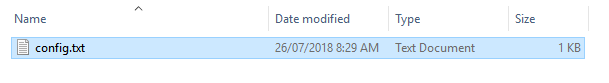 |
| There will only be a single item in the asset, its config.txt file |
| 9 |
Double Left Click on the file to open it in Notepad |
|
|
|
| |
 Edit the Config.txt File: Edit the Config.txt File:
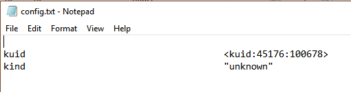 |
| You will need to edit the contents of this file. |
| 10 |
The next section,  The Config.txt File, identifies the changes you will need to make. The new name you give to the asset will not take effect until after it has been Submitted The Config.txt File, identifies the changes you will need to make. The new name you give to the asset will not take effect until after it has been Submitted |
| 11 |
After editing, save the changes and exit Notepad |
|
|
|
| |
| Warning: |
 |
Unless you know exactly what you are doing*, DO NOT ALTER THE KUID NUMBER that has been added to the file
* but even if you do, think twice before you change it !
|
|
|
| |
 Finish Up: Finish Up:
|
The Config.txt File
|
All assets must have a config.txt file |
|
 |
Settings:
The region asset must have a config.txt text file that must include the following tags:-
 |
kind set to "region" |
|
username set to the asset title or name |
|
kuid a unique ID code |
|
thumbnails set to a 240 by 180 pixel JPG image |
|
While not mandatory, the following tag is useful:-
|
category-class set to "YX" |
|
|
|
| This file should follow the same (or a similar) format as the example below. |
|
entries in red must not be changed |
|
the indenting of the lines and the spacing ("tabbing") between the "tags" on the left and their contents on the right are purely to make it easier for humans to read |
|
the use of the { } braces is to group tags into common "containers". These containers must not be broken up and the number of { characters must match the number of } characters |
|
the order of the "tags" is not important |
kuid                              <kuid: this is an auto-generated number >
kind                              " region "
username                          "Region data for Tasmania 1950 to 1969"
category-class                    " YX "
category-era                      "1950s;1960s"
category-region                   "AU"
ontheright                        0
water-color                       75,128,255
defaultjunction                   <kuid:61119:24120>
default-texture                   <kuid:-25:1180>
trainz-build                      4.8
longitude                         147.0,26.0,1.0
latitude                          41.0,50.0,-1.0
altitude                          212
car0                              <kuid:329364:1568>
thumbnails
{
  Default
  {
    width                          240
    height                         180
    image                         "Tasmania-Region.jpg"
  }
}
description                       "Vehicle, road, water and geographic data for Tasmania (Australia) in the 1950s and 1960s"
kuid-table
{
  0                               <kuid:61119:24120>
  1                               <kuid:329364:1568>
  2                               <kuid:-25:1180>
}
 |
Language Options:
|
|
All Trainz assets have a language facility built into their config.txt files that allows other language translations to be added for certain tags, such as the username and description tags. A full description of the process can be found on the Trainz Wiki at  Localize an Asset and a list of all the supported languages with their two character codes at Localization (country) Codes. Localize an Asset and a list of all the supported languages with their two character codes at Localization (country) Codes.
At the very basic level any creator can easily provide other language translations for the username and description tags in the assets they create. Examples are shown below for this sample asset. |
username                    "Region data for Tasmania 1950 to 1969"
username-c2                 "塔斯马尼亚州1950年至1969年的区域数据"
username-de                 "Regionsdaten für Tasmanien 1950 bis 1969"
username-es                 "Datos de la región para Tasmania 1950 a 1969"
username-fr                 "Données régionales pour la Tasmanie de 1950 à 1969"
username-nl                 "Regiogegevens voor Tasmanië 1950 tot 1969"
username-ru                 "Данные по регионам за Тасманию с 1950 по 1969 год"
|
|
Translations to Chinese (simplified), Spanish, French, German, Dutch and Russian, perfect or not, were provided by Google Translate.
|
Region Tags
Category Era Tag
|
 |
|
|
|
|
|
|
This tag is NOT compulsory in a Region asset |
category-era
| This identifies the decade or decades in which the region is based. The tag data contains text surrounded by quote (") characters. Each decade name ends with an "s" (e.g. "1950s") and multiple consecutive decades can be specified by using a semi-colon (;) as a separator (e.g. "1950s;1960s"). A list of category-eras can be found at Category-era tag. |
Examples:
category-era "2000s"
|
Years 2000 to 2009 |
category-era "1910s;1920s;1930s;1940s;1950s"
|
Years 1910 to 1959 |
Category Region Tag
|
|
 |
|
|
|
|
|
This tag is NOT compulsory in a Region asset |
category-region
| This identifies the country or countries in which the region is based. The tag data contains text surrounded by quote (") characters. Each country has a two letter code (e.g. "AU" for Australia) and multiple countries can be specified by using a semi-colon (;) as a separator (e.g. "AU;UK;US"). If no country is to be specified then the two character code "00" (double zero) is used. A list of countries (category regions) can be found at Category-region tag. |
Examples:
category-region "00"
|
Unassigned |
category-region "US"
|
USA |
category-region "AU;UK;NZ"
|
Australia, United Kingdom, New Zealand |
On the Right Tag
|
|
|
|
|
|
|
|
This tag is compulsory in a Region asset |
ontheright (no hyphens between the words)
This identifies which side of the road is used by road traffic in this region. The tag data contains a binary value (0 or 1). 0 = left side, 1 = right side.
United Kingdom, Ireland, Australia, New Zealand, Japan and many former British colonies would use a value of 0. Most of the rest of the world would use a value of 1. |
Examples:
ontheright 0
|
Left side driving |
ontheright 1
|
Right side driving |
Water Color Tag
|
|
|
|
|
|
|
|
The water-color tag in a Region asset has been superseded by the Water Effect Layers in Trainz Plus and TRS22. |
|
This tag is compulsory in a Region asset with an asset build number of 3.4 (TRS2010 SP4) and higher |
water-color
| This identifies the colour used by water surfaces added by the Surveyor Terrain Tool in this region. The tag contains three integers separated by commas (e.g. 75,128,255). The integers specify the RGB ( Red Green Blue ) colour values to be used and each value is from 0 to 255. |
Examples:
water-color 0,155,255
|
|
water-color 75,128,255
|
|
Default Junction Tag
|
|
|
|
|
|
|
|
This tag is compulsory in a Region asset with an asset build number of 3.4 and higher |
defaultjunction (no hyphen between the two words)
This identifies the junction lever or switch that Trainz will use as its default lever asset whenever a lever is added to a track junction in this region. The tag data contains a single valid kuid (e.g. <kuid:61119:24120>).
The kuid value of the switch lever must also be added to the kuid-table container of the config.txt file. |
Examples:
defaultjunction <kuid:61119:24120>
|
Lever Throw Over |
defaultjunction <kuid2:63290:24043:3>
|
Switch Tall Frame 1 |
Default Texture Tag
|
|
|
|
|
|
|
|
This tag is only valid in a Region asset with a build number of 4.8 and higher (TRS19 SP3 and later) |
default-texture
This identifies the default texture that will be applied to every new baseboard that is added. If it is not present then a system default texture will be used on new baseboards in Trainz TRS19 and later. If present then the Trainz Build Tag must also be present and set to a minimum value of 4.8 (TRS19 SP3 and later).
The kuid value shown in the sample config.txt above, <kuid:-25:1180>, is for the standard TRS19 grid pattern.
The kuid value of the texture must also be added to the kuid-table container of the config.txt file. |
Examples:
default-texture <kuid:-25:1180>
|
Grid (PBR) |
default-texture <kuid:455526:50038>
|
FX PBR Gravel 03 |
Trainz Build Tag
|
|
|
|
|
|
|
|
This tag is NOT compulsory in a Region asset unless the Default Texture Tag is present |
trainz-build
| This identifies the minimum version of Trainz that wlll be needed to use this region asset. A list of asset trainz-build numbers and their corresponding Trainz versions can be found at Trainz build numbers |
 |
Notes:
If this tag is present and set to a value of 3.4 or higher, then a number of other tags will become compulsory and must also be present. Specifically:-
- water-color
- defaultjunction
- longitude
- latitude
- altitude
|
|
Examples:
trainz-build 3.7
|
TRS12 SP1 and above |
trainz-build 5.0
|
TRS19 SP5 and above |
Longitude Tag
|
|
|
|
|
|
|
|
This tag is compulsory in a Region asset with an asset build number of 3.4 and higher |
|
The Longitude tag in a Region asset has been superseded by the Longitude Setting in the Environment Tools |
longitude
| This identifies the geographic longitude of a point in the region. The tag contains three floating point or decimal values separated by commas (e.g. 147.0,26.0,1.0). The first value is the longitude degrees, the second value is the longitude minutes and the third is the East/West value (1.0 = East, -1.0 = West). For example: 147.0,26.0,1.0 would represent longitude 147 degrees 26 minutes East. |
|
Notes:
There is no known feature, function or operation in a Trainz route or session that actually requires a Longitude value other than the fact that a valid Longitude Tag is compulsory in a Region asset with a build number of 3.4 and higher. |
|
Examples:
longitude 153.0,2.0,1.0
|
East |
longitude 2.0,20.0,-1.0
|
West |
Latitude Tag
|
|
|
|
|
|
|
|
This tag is compulsory in a Region asset with an asset build number of 3.4 and higher |
|
The Latitude tag in a Region asset has been superseded by the Latitude Setting in the Environment Tools |
latitude
| This identifies the geographic latitude of a point in the region. The tag contains three floating point or decimal values separated by commas (e.g. 41,0,50.0,-1.0). The first value is the latitude degrees, the second value is the latitude minutes and the third is the North/South value (1.0 = North, -1.0 = South). For example: 41.0,50.0,-1.0 would represent latitude 41 degrees 50 minutes South. |
Examples:
latitude 27.0,28.0,-1.0
|
South |
latitude 48.0,48.0,1.0
|
North |
Altitude Tag
|
|
|
|
|
|
|
|
This tag is compulsory in a Region asset with an asset build number of 3.4 and higher |
|
The Altitude tag in a Region asset has been superseded by the World Origin Altitude Setting in the Environment Tools |
|
The altitude can be set by selecting a Region:-
- when a new route is created - the route base height will be set to the altitude shown in the selected region so the first baseboard will have its height set to that altitude instead of the usual starting height of 0 metres
- when an existing route is edited by assigning it a new region - the route will have its base height set to the altitude shown in the new region and all existing heights (terrain, splines, objects) will be set relative to that value
|
altitude
This sets the initial altitude (height above sea level) of the route. It is also used in the display of snow but only with those scenery assets that have a snow effect layer.
The tag data contains a single integer that represents the altitude in metres. All terrain and object heights will be set relative to that altitude. For example: if the first baseboard of a route is manually raised to a height of 20 metres using the Terrain Height Tool and the route is then assigned to a region with the altitude set to 100 metres, then the first baseboard will have a height above sea level of 20 + 100 = 120 metres.
The altitude tag works with the Snow Altitude Setting which is set in the Environment Tools. |
|
The Default Region has an altitude of 0 metres. If you change the assigned region for an exiting route to the Default Region, then the base height of that route will be set to 0 metres and all other heights will be adjusted relative to that height. In many cases this will revert the route to its original terrain height when it was created in Surveyor and before it was assigned to a region. |
|
Examples:
altitude 0
|
metres |
altitude 100
|
metres |
Car Tags
|
|
|
|
|
|
|
|
This tag is NOT compulsory in a Region asset. If not present then no moving vehicles will appear |
|
Notes:
|
All current versions of Trainz have a limit of 15 different moving cars that can appear in a route at the same time but there can be multiple copies of each type in the route. |
|
You can list more than 15 car tags in the region asset but only 15, selected at random, will be used. |
|
The carrate tag, which is used to control the rate at which moving vehicles are created (i.e. how many per minute), has been declared obsolete in Route assets. This tag is not used in a Region asset and it only applies to road spline assets that support road traffic. |
|
|
car0, car1, car2, etc
| The Car Tag identifies the moving vehicles (cars, trucks, etc) that will appear on roads in the region. Each car tag contains just a single kuid value (e.g. <kuid:329364:1568>) that identifies a single vehicle. There are rules that must be followed:- |
|
|
Kuid Table Tag
|
|
|
|
|
|
|
|
This tag is compulsory in a Region asset if the defaultjunction, default-texture or car tags are used |
kuid-table
| This must contain the kuids of the Default Junction Tag, the Default Texture Tag and all the cars specified in the car tags - if any of them are present. The kuid order is not important and the tag numbers ("0", "1", etc) do not have to match those used in the car tags. Using the examples shown above, the kuid-table could be as shown below. |
kuid-table
{
  0                                     <kuid:61119:24120>
  1                                     <kuid:-25:1180>
  2                                     <kuid:329364:1568>
  3                                     <kuid:309161:100599>
  4                                     <kuid2:329364:1689:1>
  5                                     <kuid2:329364:1707:1>
}
In this example, the first kuid value is for the defaultjunction, the second is for the default-texture and the remaining kuid values are for the four road vehicles, but the order of the entries is not important.
|
The Thumbnail Image
|
A thumbnail image MUST be present in the asset |
Using the Asset
Once the new asset has been committed it will be available for use as a Region.
|
If the region asset is faulty (for example, if it has an incorrect kuid code in one of its car tags) then the region will not appear in the Region selection list. |
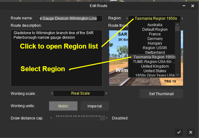
| The region is specified when a new route is created and it can be altered by selecting Edit Route from the main menu in TANE or the edit menu in TRS19 and later versions. |
Trainz Wiki
 |
More Tutorials and Guides to Using Trainz
|
This page was created by Trainz user pware in April 2020 and was last updated as shown below.