How to Create a Region Asset
m |
m (→How to Create a Region Asset: minor formatting) |
||
| (44 intermediate revisions by one user not shown) | |||
| Line 7: | Line 7: | ||
<tr valign="top"> | <tr valign="top"> | ||
<td>[[file:DotPoint.JPG|link=]]</td> | <td>[[file:DotPoint.JPG|link=]]</td> | ||
| − | <td>A '''Region''' defines the characteristics of a | + | <td>A '''Region''' defines some of the characteristics of a geographic location (e.g. a country or a province) that is represented in a route<td> |
</tr> | </tr> | ||
<tr valign="top"> | <tr valign="top"> | ||
| Line 14: | Line 14: | ||
</tr> | </tr> | ||
</table><br> | </table><br> | ||
| + | |||
| + | <table cellpadding="4" bgcolor=#ffffb0> | ||
| + | <tr valign="top"> | ||
| + | <td>[[file:NotePad.PNG|link=]]</td> | ||
| + | <td><span style="font-size: 17px; font-weight: 700;">Region Data:'''</span><br> | ||
| + | When a '''Region''' has been assigned to a route, it will set:- | ||
| + | *the default switch lever to be used in the route | ||
| + | *the colour of the water (lakes, streams, ponds, ocean) | ||
| + | *the side of the road, left or right, used by all moving road vehicles | ||
| + | *the latitude of a point in the route | ||
| + | *the longitude of a point in the route | ||
| + | *the altitude of a point in the route | ||
| + | *the number and types of moving road vehicles | ||
| + | </td> | ||
| + | </tr> | ||
| + | </table> | ||
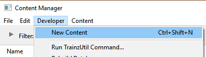
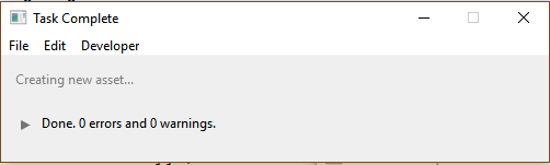
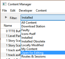
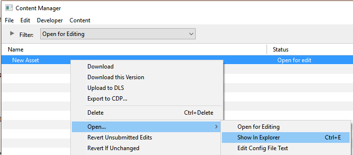
='''How to Create a Region Asset'''= | ='''How to Create a Region Asset'''= | ||
| Line 133: | Line 149: | ||
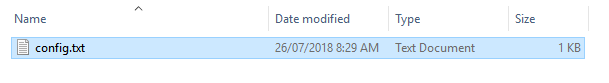
You will need to add a thumbnail image as described in the section [[file:PageLink.PNG|link=]] '''[[#The Thumbnail Image|The Thumbnail Image]]'''. The thumbnail and the config.txt files are the only two items required in this asset. | You will need to add a thumbnail image as described in the section [[file:PageLink.PNG|link=]] '''[[#The Thumbnail Image|The Thumbnail Image]]'''. The thumbnail and the config.txt files are the only two items required in this asset. | ||
<br> | <br> | ||
| + | [[file:HTMLFolderView4.JPG|link=|alt=Asset contents]] | ||
The thumbnail does not have to be added immediately but must it be present before the new asset can be used. You can reopen the asset for editing later to add the thumbnail before it is committed.</td> | The thumbnail does not have to be added immediately but must it be present before the new asset can be used. You can reopen the asset for editing later to add the thumbnail before it is committed.</td> | ||
</tr> | </tr> | ||
| Line 160: | Line 177: | ||
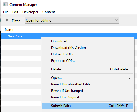
Because you still have the Filter '''Open for Editing''' in operation, the now closed and committed asset will vanish from the window display. To check that your asset has been correctly created and renamed, set the CM Search Filter to "Today".</td> | Because you still have the Filter '''Open for Editing''' in operation, the now closed and committed asset will vanish from the window display. To check that your asset has been correctly created and renamed, set the CM Search Filter to "Today".</td> | ||
</tr> | </tr> | ||
| − | </table> | + | </table> |
| + | <br> <!-- END Step 7 Notes table --> | ||
<table cellpadding="4" bgcolor=#ff0000> <!-- BEGIN Step 7 errors table --> | <table cellpadding="4" bgcolor=#ff0000> <!-- BEGIN Step 7 errors table --> | ||
<tr valign="top"> | <tr valign="top"> | ||
| Line 195: | Line 213: | ||
This file should follow the same (or a similar) format as the example below.<br> | This file should follow the same (or a similar) format as the example below.<br> | ||
| − | *entries in <span style="background-color: | + | *entries in <span style="background-color: red; color: white; font-weight: 700;"> red </span> must not be changed |
*the indenting of the lines and the spacing ("tabbing") between the "tags" on the left and their contents on the right are purely to make it easier for humans to read | *the indenting of the lines and the spacing ("tabbing") between the "tags" on the left and their contents on the right are purely to make it easier for humans to read | ||
*the use of the '''{}''' braces is to group tags into common "containers". These containers must not be broken up and the number of '''{''' characters must match the number of '''}''' characters | *the use of the '''{}''' braces is to group tags into common "containers". These containers must not be broken up and the number of '''{''' characters must match the number of '''}''' characters | ||
*the order of the "tags" is not important | *the order of the "tags" is not important | ||
| − | '''kuid''' | + | '''kuid''' <span style="background-color: red; color: white; font-weight: 700;"><kuid:this is an auto-generated number></span> |
| − | '''kind''' | + | '''kind''' "<span style="background-color: red; color: white; font-weight: 700;">region</span>" |
| − | + | '''username "Region data for Tasmania 1950 to 1969"''' | |
| − | ''' | + | '''category-class''' "<span style="background-color: red; color: white; font-weight: 700;">YX</span>" |
| − | '''category- | + | '''category-era "1950s;1960s"''' |
| − | '''category- | + | '''category-region "AU"''' |
| − | '''ontheright''' | + | '''ontheright 0''' |
| − | '''water-color | + | '''water-color 75,128,255''' |
| − | '''defaultjunction | + | '''defaultjunction <kuid:61119:24120>''' |
| − | '''longitude | + | '''longitude 147.0,26.0,1.0''' |
| − | '''latitude | + | '''latitude 41.0,50.0,-1.0''' |
| − | '''altitude''' | + | '''altitude 212''' |
| − | '''car0 | + | '''car0 <kuid:329364:1568>''' |
| − | '''trainz-build | + | '''trainz-build 4.3 |
'''thumbnails''' | '''thumbnails''' | ||
{ | { | ||
| − | + | '''Default''' | |
{ | { | ||
| − | width | + | '''width''' <span style="background-color: red; color: white; font-weight: 700;">240</span> |
| − | height | + | '''height''' <span style="background-color: red; color: white; font-weight: 700;">180</span> |
| − | + | '''image "Tasmania-Region'''<span style="background-color: red; color: white; font-weight: 700;">.jpg</span>" | |
} | } | ||
} | } | ||
| − | description | + | '''description "Vehicle, road, water and geographic data for Tasmania (Australia) in the 1950s and 1960s"''' |
| − | kuid-table | + | '''kuid-table''' |
{ | { | ||
| − | 0 | + | '''0 <kuid:61119:24120>''' |
| − | 1 | + | '''1 <kuid:329364:1568>''' |
| − | + | ||
} | } | ||
| Line 240: | Line 257: | ||
<td><span style="font-size: 17px;">'''Settings:'''</span><br> | <td><span style="font-size: 17px;">'''Settings:'''</span><br> | ||
'''For the above example:'''<br> | '''For the above example:'''<br> | ||
| − | *The <span style="background-color: | + | *The <span style="background-color: black; color: white; font-weight: 700;"> kuid </span> is unique to every asset so it is <span style="background-color: red; color: white; font-weight: 700;"> not a good idea to choose your own </span>. This will be automatically generated by the '''Content Manager''' program when a new asset is created |
| − | *The <span style="background-color: | + | *The <span style="background-color: black; color: white; font-weight: 700;"> kind </span> identifies the ''type'' of asset and the types of files that '''Trainz''' will expect to find in the asset. It also tells '''Trainz''' how to render and error check the asset. For '''region''' assets, the '''kind''' is "<span style="background-color: red; color: white; font-weight: 700;">region</span>". A list of asset kinds can be found at [[file:WikiLink.PNG|link=]] '''[[KIND_TrainzBaseSpec#KIND_Hierarchy|KIND Hierarchy]]''' |
| − | + | *The <span style="background-color: black; color: white; font-weight: 700;"> username </span> is your name for the asset and the name that other users will see. It is a good idea to make it short and meaningful. | |
| − | *The <span style="background-color: | + | *The <span style="background-color: black; color: white; font-weight: 700;"> category-class </span> identifies the ''intent'' of the asset and is important in classifying it for filtering and searching. For '''region''' assets, the category class is "<span style="background-color: red; color: white; font-weight: 700;">YX</span>". A list of category classes can be found at [[file:WikiLink.PNG|link=]] '''[[Category-class]]''' |
| − | *The <span style="background-color: | + | *The <span style="background-color: black; color: white; font-weight: 700;"> category-era </span> identifies the decade or decades in which the region is based (e.g. "1950s"). See the section [[file:PageLink.PNG|link=]] '''[[#Category Era Tag|Category Era Tag]]''' below for more details. |
| − | *The <span style="background-color: | + | *The <span style="background-color: black; color: white; font-weight: 700;"> category-region </span> identifies the country or countries in which layout is based. See the section [[file:PageLink.PNG|link=]] '''[[#Category Region Tag|Category Region Tag]]''' below for more details. |
| − | *The <span style="background-color: | + | *The <span style="background-color: black; color: white; font-weight: 700;"> ontheright </span> identifies which side of the road is used by road traffic. See the section [[file:PageLink.PNG|link=]] '''[[#On the Right Tag|On the Right Tag]]''' below for more details. |
| − | *The <span style="background-color: | + | *The <span style="background-color: black; color: white; font-weight: 700;"> water-color </span> identifies the the colour used by water surfaces in this region. See the section [[file:PageLink.PNG|link=]] '''[[#Water Color Tag|Water Color Tag]]''' below for more details. |
| − | *The <span style="background-color: | + | *The <span style="background-color: black; color: white; font-weight: 700;"> defaultjunction </span> identifies the junction lever or switch that Trainz will use as its default lever asset whenever a lever is added to a track junction in this region. See the section [[file:PageLink.PNG|link=]] '''[[#Default Junction Tag|Default Junction Tag]]''' below for more details. |
| − | *The <span style="background-color: | + | *The <span style="background-color: black; color: white; font-weight: 700;"> longitude </span> identifies the geographic longitude of a point in the region. See the section [[file:PageLink.PNG|link=]] '''[[#Longitude Tag|Longitude Tag]]''' below for more details. |
| − | *The <span style="background-color: | + | *The <span style="background-color: black; color: white; font-weight: 700;"> latitude </span> identifies the geographic latitude of a point in the region. See the section [[file:PageLink.PNG|link=]] '''[[#Latitude Tag|Latitude Tag]]''' below for more details. |
| − | *The <span style="background-color: | + | *The <span style="background-color: black; color: white; font-weight: 700;"> altitude </span> identifies the altitude or '''base height''' of the starting baseboard in the route. See the section [[file:PageLink.PNG|link=]] '''[[#Altitude Tag|Altitude Tag]]''' below for more details. |
| − | *The <span style="background-color: | + | *The <span style="background-color: black; color: white; font-weight: 700;"> car0 </span> identifies the first moving car that will appear on roads in the region. Upto 15 different cars can be specified. See the section [[file:PageLink.PNG|link=]] '''[[#Car Tags|Car Tags]]''' below for more details. |
| − | *The <span style="background-color: | + | *The <span style="background-color: black; color: white; font-weight: 700;"> trainz-build </span> identifies the ''minimum'' Trainz version needed for this asset. A list of asset trainz-build numbers and their corresponding Trainz versions can be found at [[file:WikiLink.PNG|link=]] '''[["Trainz-build"_number|Trainz build numbers]]''' |
| − | *The <span style="background-color: | + | *The <span style="background-color: black; color: white; font-weight: 700;"> thumbnails </span> container holds the ''preview'' images of the asset shown by the '''Content Manager''' program, the Web version of the ''DLS'' and, for '''some assets''', the Surveyor main menu image(s). See the section [[file:PageLink.PNG|link=]] '''[[#Thumbnails|Thumbnails]]''' below for more details. Complete information on thumbnails can be found at [[file:WikiLink.PNG|link=]] '''[[Thumbnails]]''' |
| − | *The <span style="background-color: | + | **The label <span style="background-color: black; color: white; font-weight: 700;"> Default </span> is the '''container ID''' or '''placeholder''' for the thumbnail used by CM and the Web based DLS. While its ''exact label'' (or number - eg. "Default", "00", "01", etc) is not important, it must be different from any other labels that might be present in the thumbnail. '''Default''' and '''0''' are commonly used placeholder labels for the 240 x 180 thumbnail image |
| − | **The label <span style="background-color: | + | ***The '''image''' is the name of the thumbnail image. It does not have to be called '''thumbnail.jpg''' but it '''must''' be a <span style="background-color: red; color: white; font-weight: 700;">JPG</span> format image |
| − | ***The '''image''' is the name of the thumbnail image | + | ***The '''width''' of the image in pixels must be <span style="background-color: red; color: white; font-weight: 700;">240</span> |
| − | ***The '''width''' of the image must be | + | ***The '''height''' of the image in pixels must be <span style="background-color: red; color: white; font-weight: 700;">180</span> |
| − | ***The '''height''' of the image must be | + | *The <span style="background-color: black; color: white; font-weight: 700;"> description </span> provides more details for users than the '''username''' |
| − | *The <span style="background-color: | + | *The <span style="background-color: black; color: white; font-weight: 700;"> kuid-table </span> contains the kuid values of the '''defaultjunction''' asset and all the '''carN''' assets. See the section [[file:PageLink.PNG|link=]] '''[[#Kuid Table Tag|Kuid Table Tag]]''' below for more details. |
| − | *The <span style="background-color: | + | |
</td> | </td> | ||
</tr> | </tr> | ||
| Line 277: | Line 293: | ||
<tr valign="top"> | <tr valign="top"> | ||
<td></td> | <td></td> | ||
| − | <td>All Trainz assets have a language facility built into their config.txt files that allows other language translations to be added for certain tags, such as the '''username''' and '''description''' tags. A full description of the process can be found on the Trainz Wiki at '''[[HowTo/Localize_an_Asset|Localize an Asset]]''' and a list of all the supported languages with their two character codes at [[file:WikiLink.PNG|link=]] '''[[Localization_code|Localization (country) Codes]]'''.<br> | + | <td>All Trainz assets have a language facility built into their config.txt files that allows other language translations to be added for certain tags, such as the '''username''' and '''description''' tags. A full description of the process can be found on the Trainz Wiki at [[file:WikiLink.PNG|link=]] '''[[HowTo/Localize_an_Asset|Localize an Asset]]''' and a list of all the supported languages with their two character codes at [[file:WikiLink.PNG|link=]] '''[[Localization_code|Localization (country) Codes]]'''.<br> |
At the very basic level any creator can easily provide other language translations for the '''username''' and '''description''' tags in the assets they create. Examples are shown below for this sample asset.</td> | At the very basic level any creator can easily provide other language translations for the '''username''' and '''description''' tags in the assets they create. Examples are shown below for this sample asset.</td> | ||
| Line 283: | Line 299: | ||
<tr valign="top"> | <tr valign="top"> | ||
<td colspan=2> | <td colspan=2> | ||
| − | username "Tasmania | + | username "Region data for Tasmania 1950 to 1969" |
| − | username-c2 "" | + | username-c2 "塔斯马尼亚州1950年至1969年的区域数据" |
| − | username-es "" | + | username-es "Datos de la región para Tasmania 1950 a 1969" |
| − | username-fr "" | + | username-fr "Données régionales pour la Tasmanie de 1950 à 1969" |
| − | username-gr "" | + | username-gr "Regionsdaten für Tasmanien 1950 bis 1969" |
| − | username-nl "" | + | username-nl "Regiogegevens voor Tasmanië 1950 tot 1969" |
| − | username-ru "" | + | username-ru "Данные по регионам за Тасманию с 1950 по 1969 год" |
</td> | </td> | ||
</tr> | </tr> | ||
| Line 307: | Line 323: | ||
=='''Category Era Tag'''== | =='''Category Era Tag'''== | ||
| − | This identifies the decade or decades in which the region is based. Each decade name ends with an "s" (e.g. "1950s") and multiple consecutive decades can be specified by using a semi-colon (;) as a separator (e.g. "1950s;1960s"). A list of category-eras can be found at [[file:WikiLink.PNG|link=]] '''[["Category-era"_tag|Category-era tag]]'''. | + | <table cellpadding="4" bgcolor=#c1e7e7> |
| + | <tr valign="top"> | ||
| + | <td>[[file:DotPoint.JPG|link=]]</td> | ||
| + | <td>This tag is <span style="background-color: blue; color: white; font-weight: 700;"> NOT compulsory </span> in a Region asset</td> | ||
| + | </tr> | ||
| + | </table> | ||
| + | <br> | ||
| + | This identifies the decade or decades in which the region is based. The tag data contains text surrounded by quote (") characters. Each decade name ends with an "s" (e.g. "1950s") and multiple consecutive decades can be specified by using a semi-colon (;) as a separator (e.g. "1950s;1960s"). A list of category-eras can be found at [[file:WikiLink.PNG|link=]] '''[["Category-era"_tag|Category-era tag]]'''. | ||
=='''Category Region Tag'''== | =='''Category Region Tag'''== | ||
| − | This identifies the country or countries in which the region is based. Each country has a two letter code (e.g. "AU" for Australia) and multiple countries can be specified by using a semi-colon (;) as a separator (e.g. "AU;UK;US"). If no country is to be specified then the two character code "00" (double zero) is used. A list of countries (category regions) can be found at [[file:WikiLink.PNG|link=]] '''[[ | + | <table cellpadding="4" bgcolor=#c1e7e7> |
| + | <tr valign="top"> | ||
| + | <td>[[file:DotPoint.JPG|link=]]</td> | ||
| + | <td>This tag is <span style="background-color: blue; color: white; font-weight: 700;"> NOT compulsory </span> in a Region asset</td> | ||
| + | </tr> | ||
| + | </table> | ||
| + | <br> | ||
| + | This identifies the country or countries in which the region is based. The tag data contains text surrounded by quote (") characters. Each country has a two letter code (e.g. "AU" for Australia) and multiple countries can be specified by using a semi-colon (;) as a separator (e.g. "AU;UK;US"). If no country is to be specified then the two character code "00" (double zero) is used. A list of countries (category regions) can be found at [[file:WikiLink.PNG|link=]] '''[["Category-region"_tag|Category-region tag]]'''. | ||
=='''On the Right Tag'''== | =='''On the Right Tag'''== | ||
| − | This identifies which side of the road is used by road traffic in this region. 0 = left side, 1 = right side | + | <table cellpadding="4" bgcolor=#c1e7e7> |
| + | <tr valign="top"> | ||
| + | <td>[[file:DotPoint.JPG|link=]]</td> | ||
| + | <td>This tag is <span style="background-color: red; color: white; font-weight: 700;"> compulsory </span> in a Region asset</td> | ||
| + | </tr> | ||
| + | </table> | ||
| + | <br> | ||
| + | This identifies which side of the road is used by road traffic in this region. The tag data contains a binary value (0 or 1). 0 = left side, 1 = right side. | ||
=='''Water Color Tag'''== | =='''Water Color Tag'''== | ||
| Line 325: | Line 362: | ||
<tr valign="top"> | <tr valign="top"> | ||
<td>[[file:Stop.PNG|link=]]</td> | <td>[[file:Stop.PNG|link=]]</td> | ||
| − | <td>The '''water-color tag''' in a '''Region''' asset has been | + | <td>The '''water-color tag''' in a '''Region''' asset has been superseded by the '''Water Color Lighting Setting''' used in '''TANE''' and '''TRS19''' [[file:WikiLink.PNG|link=]] '''[[How_to_Use_Environment_Tools|Environment Tools]]'''</td> |
</tr> | </tr> | ||
</table> | </table> | ||
| − | + | <br> | |
| − | This identifies | + | <table cellpadding="4" bgcolor=#c1e7e7> |
| + | <tr valign="top"> | ||
| + | <td>[[file:DotPoint.JPG|link=]]</td> | ||
| + | <td>This tag is <span style="background-color: red; color: white; font-weight: 700;"> compulsory </span> in a Region asset with an asset build number of 3.4 and higher</td> | ||
| + | </tr> | ||
| + | </table> | ||
| + | <br> | ||
| + | This identifies the colour used by water surfaces added by the Surveyor '''Terrain Tool''' in this region. The tag contains three integers separated by commas (e.g. 75,128,255). The integers specify the RGB ('''R'''ed, '''G'''reen, '''B'''lue) colour values to be used and each value is from 0 to 255. | ||
=='''Default Junction Tag'''== | =='''Default Junction Tag'''== | ||
| − | This identifies the junction lever or switch that Trainz will use as its default lever asset whenever a lever is added to a track junction in this region. The | + | <table cellpadding="4" bgcolor=#c1e7e7> |
| + | <tr valign="top"> | ||
| + | <td>[[file:DotPoint.JPG|link=]]</td> | ||
| + | <td>This tag is <span style="background-color: red; color: white; font-weight: 700;"> compulsory </span> in a Region asset with an asset build number of 3.4 and higher</td> | ||
| + | </tr> | ||
| + | </table> | ||
| + | <br> | ||
| + | This identifies the junction lever or switch that Trainz will use as its default lever asset whenever a lever is added to a track junction in this region. The tag data contains a single valid kuid (e.g. <kuid:61119:24120>).<br> | ||
| − | The kuid value of the switch lever must be added to the '''kuid-table''' container of the config.txt file. | + | The kuid value of the switch lever must also be added to the '''kuid-table''' container of the config.txt file. |
=='''Longitude Tag'''== | =='''Longitude Tag'''== | ||
| − | This identifies the geographic longitude of a point in the region. | + | <table cellpadding="4" bgcolor=#c1e7e7> |
| + | <tr valign="top"> | ||
| + | <td>[[file:DotPoint.JPG|link=]]</td> | ||
| + | <td>This tag is <span style="background-color: red; color: white; font-weight: 700;"> compulsory </span> in a Region asset with an asset build number of 3.4 and higher</td> | ||
| + | </tr> | ||
| + | </table> | ||
| + | <br> | ||
| + | This identifies the geographic longitude of a point in the region. The tag contains three ''floating point'' or ''decimal'' values separated by commas (e.g. 147.0,26.0,1.0). The first value is the longitude '''degrees''', the second value is the longitude '''minutes''' and the third is the '''East/West''' value (1.0 = East, -1.0 = West). For example: 147.0,26.0,1.0 would represent longitude 147 degrees 26 minutes East.<br> | ||
=='''Latitude Tag'''== | =='''Latitude Tag'''== | ||
| − | This identifies the geographic latitude of a point in the region. | + | <table cellpadding="4" bgcolor=#c1e7e7> |
| + | <tr valign="top"> | ||
| + | <td>[[file:DotPoint.JPG|link=]]</td> | ||
| + | <td>This tag is <span style="background-color: red; color: white; font-weight: 700;"> compulsory </span> in a Region asset with an asset build number of 3.4 and higher</td> | ||
| + | </tr> | ||
| + | </table> | ||
| + | <br> | ||
| + | This identifies the geographic latitude of a point in the region. The tag contains three ''floating point'' or ''decimal'' values separated by commas (e.g. 41,0,50.0,-1.0). The first value is the latitude '''degrees''', the second value is the latitude '''minutes''' and the third is the '''North/South''' value (1.0 = North, -1.0 = South). For example: 41,0,50.0,-1.0 would represent latitude 41 degrees 50 minutes South.<br> | ||
=='''Altitude Tag'''== | =='''Altitude Tag'''== | ||
| − | This | + | <table cellpadding="4" bgcolor=#c1e7e7> |
| + | <tr valign="top"> | ||
| + | <td>[[file:DotPoint.JPG|link=]]</td> | ||
| + | <td>This tag is <span style="background-color: red; color: white; font-weight: 700;"> compulsory </span> in a Region asset with an asset build number of 3.4 and higher</td> | ||
| + | </tr> | ||
| + | </table> | ||
| + | <br> | ||
| + | <table cellpadding="4" bgcolor=#c1e7e7> | ||
| + | <tr valign="top"> | ||
| + | <td>[[file:DotPoint.JPG|link=]]</td> | ||
| + | <td>The altitude can be set by selecting a '''Region''':- | ||
| + | *when a new route is created - the route '''base height''' will be set to the altitude shown in the selected region so the first baseboard will have its height set to that altitude instead of the usual starting height of 0 metres | ||
| + | *when an existing route is edited by assigning it a new region - the route will have its '''base height''' set to the altitude shown in the new region and all existing heights (terrain, splines, objects) will be set relative to that value</td> | ||
| + | </tr> | ||
| + | </table> | ||
| + | <br> | ||
| + | This sets the initial altitude (height above sea level) of the route. The tag data contains a single integer that represents the altitude in metres. All terrain and object heights will be set relative to that altitude. For example: if the first baseboard of a route is manually raised to a height of 20 metres and the route is then assigned to a region with an altitude set to 100 metres, then the first baseboard will have a height above sea level of 20 + 100 = 120 metres. | ||
| + | <br> | ||
| + | The altitude is needed in the display of snow effects, for those assets that support snow, and works with the '''Snow Altitude Setting''' used in '''TANE''' and '''TRS19''' [[file:WikiLink.PNG|link=]] '''[[How_to_Use_Environment_Tools|Environment Tools]]'''.<br> | ||
| + | |||
| + | <table cellpadding="4" bgcolor=#ffffb0> | ||
| + | <tr valign="top"> | ||
| + | <td>[[file:PencilTips.PNG|link=]]</td> | ||
| + | <td>The '''Default Region''' has an altitude of 0 metres. If you change the assigned region for an exiting route to the '''Default Region''', then the '''base height''' of that route will be set to 0 metres and all other heights will be adjusted relative to that height. In many cases this will revert the route to its original terrain heights when it was created in Surveyor and before it was assigned to a region.</td> | ||
| + | </tr> | ||
| + | </table> | ||
=='''Car Tags'''== | =='''Car Tags'''== | ||
| − | This identifies the moving cars that will appear on roads in the region. | + | <table cellpadding="4" bgcolor=#c1e7e7> |
| − | * | + | <tr valign="top"> |
| − | *The cars must be | + | <td>[[file:DotPoint.JPG|link=]]</td> |
| − | + | <td>This tag is <span style="background-color: blue; color: white; font-weight: 700;"> NOT compulsory </span> in a Region asset. If not present then no moving cars will appear</td> | |
| − | + | </tr> | |
| − | *The '''Environment | + | </table> |
| + | <br> | ||
| + | This identifies the moving cars that will appear on roads in the region. The tag data contains a single valid kuid (e.g. <kuid:329364:1568>) . There are restrictions and requirements:- | ||
| + | *Up to 15 different cars, each as a separate tag from '''car0''' to '''car14''' with their '''kuid''' values, can be specified in a region. The car tag numbers must be consecutive with no missing or duplicated entries | ||
| + | *'''The cars must be configured as moving vehicles''' and not as static vehicles - static car assets cannot be used. See [[file:WikiLink.PNG|link=]] '''[[HowTo/Build_a_Car_for_Traffic_(stand-alone_version)#Load_Model_into_Trainz|Build a Car for Traffic]]''' for information on how to configure a static car asset for road traffic | ||
| + | *'''Not all roads are configured to carry moving vehicles''' | ||
| + | *The [[file:WikiLink.PNG|link=]] '''[[How_to_Use_Environment_Tools|Environment Tools]]''' has a control that will '''enable''' and '''disable''' all road traffic | ||
*The kuids of the cars must be added to the '''kuid-table''' container of the config.txt file | *The kuids of the cars must be added to the '''kuid-table''' container of the config.txt file | ||
For example, the following entries will specify just 4 moving vehicles for the region. | For example, the following entries will specify just 4 moving vehicles for the region. | ||
| Line 366: | Line 462: | ||
=='''Kuid Table Tag'''== | =='''Kuid Table Tag'''== | ||
| − | This must contain the | + | <table cellpadding="4" bgcolor=#c1e7e7> |
| + | <tr valign="top"> | ||
| + | <td>[[file:DotPoint.JPG|link=]]</td> | ||
| + | <td>This tag is <span style="background-color: red; color: white; font-weight: 700;"> compulsory </span> in a Region asset if the '''defaultjunction''' or '''car''' tags are used</td> | ||
| + | </tr> | ||
| + | </table> | ||
| + | <br> | ||
| + | This must contain the kuids of the '''Default Junction''' asset and all the cars specified in the '''car''' tags. The kuid order is not important and the tag numbers ("0", "1", etc) do not have to match those used in the '''car''' tags. Using the examples shown above, the '''kuid-table''' could be as shown below. | ||
kuid-table | kuid-table | ||
{ | { | ||
| − | 0 <kuid: | + | 0 <kuid:61119:24120> |
| − | 1 <kuid: | + | 1 <kuid:329364:1568> |
| − | 2 < | + | 2 <kuid:309161:100599> |
| − | 3 <kuid2:329364: | + | 3 <kuid2:329364:1689:1> |
| − | 4 < | + | 4 <kuid2:329364:1707:1> |
} | } | ||
| + | |||
| + | In this example, the first kuid value is for the '''defaultjunction''' and the remaining kuid values are for the four road vehicles, but the order of the entries is not important. | ||
| + | |||
| + | <table width="100%"> | ||
| + | <tr valign="top"> | ||
| + | <td align="right">[[file:BackToTop.png|link=#top|alt=Top|Top]]</td> | ||
| + | </tr> | ||
| + | </table> | ||
='''The Thumbnail Image'''= | ='''The Thumbnail Image'''= | ||
| Line 402: | Line 513: | ||
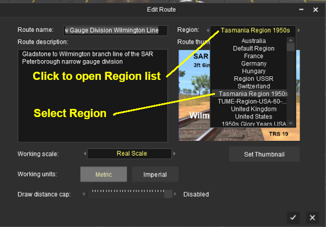
The region is specified when a new route is created and it can be altered by selecting '''Edit Route''' from the main menu in '''TANE''' or the edit menu in '''TRS19'''. | The region is specified when a new route is created and it can be altered by selecting '''Edit Route''' from the main menu in '''TANE''' or the edit menu in '''TRS19'''. | ||
| + | |||
| + | [[file:TasmaniaRegion.png|link=|alt=Load a Region]] | ||
<table width="100%"> | <table width="100%"> | ||
| Line 411: | Line 524: | ||
---- | ---- | ||
---- | ---- | ||
| + | |||
='''Trainz Wiki'''= | ='''Trainz Wiki'''= | ||
<table cellpadding="4" bgcolor=#ffffff> | <table cellpadding="4" bgcolor=#ffffff> | ||
Revision as of 11:01, 23 August 2020
The information in this Wiki Page applies to TANE, TRS19 and Trainz Plus.
Contents |
What is a Region?
| A Region defines some of the characteristics of a geographic location (e.g. a country or a province) that is represented in a route | ||
| A Region Asset is a config.txt file that contains the region data |
| Region Data: When a Region has been assigned to a route, it will set:-
|
How to Create a Region Asset
 Steps |
|
|||||||
|
|
||||||||
|
||||||||
|
|
||||||||
|
||||||||
|
|
||||||||
|
||||||||
|
|
||||||||
|
||||||||
|
|
||||||||
|
||||||||
|
|
||||||||
|
||||||||
The Config.txt File
This file should follow the same (or a similar) format as the example below.
- entries in red must not be changed
- the indenting of the lines and the spacing ("tabbing") between the "tags" on the left and their contents on the right are purely to make it easier for humans to read
- the use of the {} braces is to group tags into common "containers". These containers must not be broken up and the number of { characters must match the number of } characters
- the order of the "tags" is not important
kuid                              <kuid:this is an auto-generated number>
kind                              "region"
username                          "Region data for Tasmania 1950 to 1969"
category-class                    "YX"
category-era                      "1950s;1960s"
category-region                   "AU"
ontheright                        0
water-color                       75,128,255
defaultjunction                   <kuid:61119:24120>
longitude                         147.0,26.0,1.0
latitude                          41.0,50.0,-1.0
altitude                          212
car0                              <kuid:329364:1568>
trainz-build                      4.3
thumbnails
{
  Default
  {
    width                         240
    height                        180
    image                         "Tasmania-Region.jpg"
  }
}
description                       "Vehicle, road, water and geographic data for Tasmania (Australia) in the 1950s and 1960s"
kuid-table
{
  0                               <kuid:61119:24120>
  1                               <kuid:329364:1568>
}
|
|
|
| Settings: For the above example:
|
|
|
|
|
| Language Options: | |
| All Trainz assets have a language facility built into their config.txt files that allows other language translations to be added for certain tags, such as the username and description tags. A full description of the process can be found on the Trainz Wiki at At the very basic level any creator can easily provide other language translations for the username and description tags in the assets they create. Examples are shown below for this sample asset. |
|
username "Region data for Tasmania 1950 to 1969" username-c2 "塔斯马尼亚州1950年至1969年的区域数据" username-es "Datos de la región para Tasmania 1950 a 1969" username-fr "Données régionales pour la Tasmanie de 1950 à 1969" username-gr "Regionsdaten für Tasmanien 1950 bis 1969" username-nl "Regiogegevens voor Tasmanië 1950 tot 1969" username-ru "Данные по регионам за Тасманию с 1950 по 1969 год" |
|
| Translations to Chinese (simplified), Spanish, French, German, Dutch and Russian, perfect or not, were provided by Google Translate. | |
Category Era Tag
| This tag is NOT compulsory in a Region asset |
This identifies the decade or decades in which the region is based. The tag data contains text surrounded by quote (") characters. Each decade name ends with an "s" (e.g. "1950s") and multiple consecutive decades can be specified by using a semi-colon (;) as a separator (e.g. "1950s;1960s"). A list of category-eras can be found at ![]() Category-era tag.
Category-era tag.
Category Region Tag
| This tag is NOT compulsory in a Region asset |
This identifies the country or countries in which the region is based. The tag data contains text surrounded by quote (") characters. Each country has a two letter code (e.g. "AU" for Australia) and multiple countries can be specified by using a semi-colon (;) as a separator (e.g. "AU;UK;US"). If no country is to be specified then the two character code "00" (double zero) is used. A list of countries (category regions) can be found at ![]() Category-region tag.
Category-region tag.
On the Right Tag
| This tag is compulsory in a Region asset |
This identifies which side of the road is used by road traffic in this region. The tag data contains a binary value (0 or 1). 0 = left side, 1 = right side.
Water Color Tag
| Warning: | |
| The water-color tag in a Region asset has been superseded by the Water Color Lighting Setting used in TANE and TRS19 |
|
| This tag is compulsory in a Region asset with an asset build number of 3.4 and higher |
This identifies the colour used by water surfaces added by the Surveyor Terrain Tool in this region. The tag contains three integers separated by commas (e.g. 75,128,255). The integers specify the RGB (Red, Green, Blue) colour values to be used and each value is from 0 to 255.
Default Junction Tag
| This tag is compulsory in a Region asset with an asset build number of 3.4 and higher |
This identifies the junction lever or switch that Trainz will use as its default lever asset whenever a lever is added to a track junction in this region. The tag data contains a single valid kuid (e.g. <kuid:61119:24120>).
The kuid value of the switch lever must also be added to the kuid-table container of the config.txt file.
Longitude Tag
| This tag is compulsory in a Region asset with an asset build number of 3.4 and higher |
This identifies the geographic longitude of a point in the region. The tag contains three floating point or decimal values separated by commas (e.g. 147.0,26.0,1.0). The first value is the longitude degrees, the second value is the longitude minutes and the third is the East/West value (1.0 = East, -1.0 = West). For example: 147.0,26.0,1.0 would represent longitude 147 degrees 26 minutes East.
Latitude Tag
| This tag is compulsory in a Region asset with an asset build number of 3.4 and higher |
This identifies the geographic latitude of a point in the region. The tag contains three floating point or decimal values separated by commas (e.g. 41,0,50.0,-1.0). The first value is the latitude degrees, the second value is the latitude minutes and the third is the North/South value (1.0 = North, -1.0 = South). For example: 41,0,50.0,-1.0 would represent latitude 41 degrees 50 minutes South.
Altitude Tag
| This tag is compulsory in a Region asset with an asset build number of 3.4 and higher |
The altitude can be set by selecting a Region:-
|
This sets the initial altitude (height above sea level) of the route. The tag data contains a single integer that represents the altitude in metres. All terrain and object heights will be set relative to that altitude. For example: if the first baseboard of a route is manually raised to a height of 20 metres and the route is then assigned to a region with an altitude set to 100 metres, then the first baseboard will have a height above sea level of 20 + 100 = 120 metres.
The altitude is needed in the display of snow effects, for those assets that support snow, and works with the Snow Altitude Setting used in TANE and TRS19 ![]() Environment Tools.
Environment Tools.
| The Default Region has an altitude of 0 metres. If you change the assigned region for an exiting route to the Default Region, then the base height of that route will be set to 0 metres and all other heights will be adjusted relative to that height. In many cases this will revert the route to its original terrain heights when it was created in Surveyor and before it was assigned to a region. |
Car Tags
| This tag is NOT compulsory in a Region asset. If not present then no moving cars will appear |
This identifies the moving cars that will appear on roads in the region. The tag data contains a single valid kuid (e.g. <kuid:329364:1568>) . There are restrictions and requirements:-
- Up to 15 different cars, each as a separate tag from car0 to car14 with their kuid values, can be specified in a region. The car tag numbers must be consecutive with no missing or duplicated entries
- The cars must be configured as moving vehicles and not as static vehicles - static car assets cannot be used. See
 Build a Car for Traffic for information on how to configure a static car asset for road traffic
- Not all roads are configured to carry moving vehicles
- The Environment Tools has a control that will enable and disable all road traffic
- The kuids of the cars must be added to the kuid-table container of the config.txt file
For example, the following entries will specify just 4 moving vehicles for the region.
car0                                    <kuid:329364:1568>
car1                                    <kuid:309161:100599>
car2                                    <kuid2:329364:1689:1>
car3                                    <kuid2:329364:1707:1>
Kuid Table Tag
| This tag is compulsory in a Region asset if the defaultjunction or car tags are used |
This must contain the kuids of the Default Junction asset and all the cars specified in the car tags. The kuid order is not important and the tag numbers ("0", "1", etc) do not have to match those used in the car tags. Using the examples shown above, the kuid-table could be as shown below.
kuid-table
{
  0                                     <kuid:61119:24120>
  1                                     <kuid:329364:1568>
  2                                     <kuid:309161:100599>
  3                                     <kuid2:329364:1689:1>
  4                                     <kuid2:329364:1707:1>
}
In this example, the first kuid value is for the defaultjunction and the remaining kuid values are for the four road vehicles, but the order of the entries is not important.
The Thumbnail Image
| A thumbnail image MUST be present in the asset |
| Notes: The thumbnail image:-
|
Using the Asset
Once the new asset has been committed it will be available for use as a Region.
The region is specified when a new route is created and it can be altered by selecting Edit Route from the main menu in TANE or the edit menu in TRS19.
Trainz Wiki
 |
More Tutorials and Guides to Using Trainz |
This page was created by Trainz user pware in April 2020 and was last updated as shown below.