File:SAR Peterborough-Terowie Strip Map.png
From TrainzOnline
(Difference between revisions)
(Pware uploaded a new version of "File:SAR Peterborough-Terowie Strip Map.png": Reverted to version as of 11:42, 9 August 2019) |
(Pware uploaded a new version of "File:SAR Peterborough-Terowie Strip Map.png": Added coal icons) |
Latest revision as of 12:58, 27 March 2020
Strip map of the Peterborough to Terowie Line of the SAR Peterborough Narrow Gauge Division project
File history
Click on a date/time to view the file as it appeared at that time.
| Date/Time | Thumbnail | Dimensions | User | Comment | |
|---|---|---|---|---|---|
| current | 12:58, 27 March 2020 | 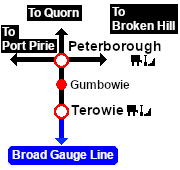 | 180 × 170 (8 KB) | Pware (Talk | contribs) | Added coal icons |
| 07:48, 2 December 2019 |  | 180 × 170 (8 KB) | Pware (Talk | contribs) | Reverted to version as of 11:42, 9 August 2019 | |
| 18:06, 17 November 2019 | 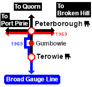 | 180 × 170 (8 KB) | Pware (Talk | contribs) | Update | |
| 12:07, 17 November 2019 |  | 180 × 170 (8 KB) | Pware (Talk | contribs) | Updated to include conversion to Broad Gauge in 1969 | |
| 21:42, 9 August 2019 |  | 180 × 170 (8 KB) | Pware (Talk | contribs) | Update | |
| 15:50, 13 July 2019 | 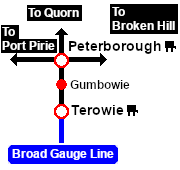 | 180 × 170 (8 KB) | Pware (Talk | contribs) | Update | |
| 21:25, 11 July 2019 | 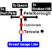 | 180 × 170 (7 KB) | Pware (Talk | contribs) | Update | |
| 21:41, 4 July 2019 | 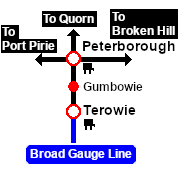 | 180 × 170 (7 KB) | Pware (Talk | contribs) | Update | |
| 14:03, 4 July 2019 | 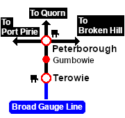 | 180 × 170 (7 KB) | Pware (Talk | contribs) | Update | |
| 22:16, 29 March 2019 | 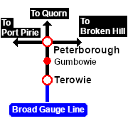 | 180 × 170 (7 KB) | Pware (Talk | contribs) | Strip map of the Peterborough to Terowie Line of the SAR Peterborough Narrow Gauge Division project |
- Edit this file using an external application (See the [//www.mediawiki.org/wiki/Manual:External_editors setup instructions] for more information)
File usage
The following 39 pages link to this file:
- SAR Gumbowie
- SAR Gumbowie Paths
- SAR Gumbowie Switches
- SAR Gumbowie Switches V1
- SAR Gumbowie Switches V2
- SAR Gumbowie TrackMarks
- SAR Gumbowie TrackMarks V1
- SAR Gumbowie TrackMarks V2
- SAR Gumbowie V1
- SAR Gumbowie V2
- SAR Peterborough
- SAR Peterborough Industry
- SAR Peterborough Industry V1
- SAR Peterborough Industry V2
- SAR Peterborough Paths
- SAR Peterborough Switches
- SAR Peterborough Switches V1
- SAR Peterborough Switches V2
- SAR Peterborough TrackMarks
- SAR Peterborough TrackMarks V1
- SAR Peterborough TrackMarks V2
- SAR Peterborough V1
- SAR Peterborough V2
- SAR SAR Terowie Industry V2
- SAR Terowie
- SAR Terowie Industry
- SAR Terowie Industry V1
- SAR Terowie Industry V2
- SAR Terowie Paths
- SAR Terowie Switches
- SAR Terowie Switches V1
- SAR Terowie Switches V2
- SAR Terowie TrackMarks
- SAR Terowie TrackMarks V1
- SAR Terowie TrackMarks V2
- SAR Terowie V1
- SAR Terowie V2
- Template:SAR Peterborough Paths
- Template:Scrolling window/SAR Peterborough Paths