SAR Methuen V1
From TrainzOnline
(Difference between revisions)
(Created page with "<!-- V1.0 --> <table> <!-- BEGIN TOP TABLE --> <tr valign="top"> <td width=750> <table width=750> <!-- BEGIN TABBED link list with Track Marks page active--> <tr valign="to...") |
m |
||
| (One intermediate revision by one user not shown) | |||
| Line 4: | Line 4: | ||
<td width=750> | <td width=750> | ||
| − | <table width=750> <!-- BEGIN TABBED link list with | + | <table width=750> <!-- BEGIN TABBED link list with Home page active--> |
<tr valign="top"> | <tr valign="top"> | ||
<td align="center">[[Image:line740.png|link=]]</td> | <td align="center">[[Image:line740.png|link=]]</td> | ||
</tr> | </tr> | ||
<tr valign="top"> | <tr valign="top"> | ||
| − | <td align="center">[[image: | + | <td align="center">[[image:Tab_HM_White.png|link=]] [[image:Tab_Blank_Grey.png|link=]] [[image:Tab_TM_Grey.png|link=SAR_Methuen_TrackMarks_V1]] [[image:Tab_SW_Grey.png|link=SAR_Methuen_Switches_V1]] [[image:Tab_Blank_Grey.png|link=]]</td> |
</tr> | </tr> | ||
<tr valign="top"> | <tr valign="top"> | ||
| Line 26: | Line 26: | ||
</tr> | </tr> | ||
| − | </table> <!-- | + | </table> <!-- END Location link table with LINE and STATION NAMES --> |
<table width=750> | <table width=750> | ||
<tr valign="top"> | <tr valign="top"> | ||
| − | <td>[[image: | + | <td>[[image:SAR_Methuen.png|link=|alt=Methuen map]]</td> |
</tr> | </tr> | ||
<tr valign="top"> | <tr valign="top"> | ||
| − | <td align="center"><span style="font-weight: 700;"> | + | <td align="center"><span style="font-weight: 700;">For <span style="color: blue;">SAR Peterborough Narrow Gauge Division v1.0</span>. For the latest <span style="color: blue;">V2.0</span> click <span style="background-color: yellow;">[[SAR_Methuen_V2|here]]</span></span></td> |
</tr> | </tr> | ||
</table> | </table> | ||
| − | <table | + | <table width=750> |
<tr valign="top"> | <tr valign="top"> | ||
| − | <td | + | <td align="center">[[Image:line740.png|link=]]</td> |
</tr> | </tr> | ||
| + | </table> | ||
| + | |||
| + | <table bgcolor="lightgrey" bordercolor="lightgrey" width=750> <!-- BEGIN Location details table --> | ||
| + | |||
| + | <tr valign="top"> | ||
| + | <td> | ||
| + | |||
| + | <table width=300> <!-- BEGIN Commodities table (5 items) --> | ||
| + | <tr valign="top"> | ||
| + | |||
| + | <td width=300> </td> <!-- holding space 1-5 for no Commodity items - REMOVE "Commodities" label --> | ||
| − | |||
| − | |||
</tr> | </tr> | ||
| − | < | + | </table> <!-- END Commodities Table --> |
| − | <td | + | |
| + | </td> | ||
| + | <td> | ||
| + | |||
| + | <table width=175> <!-- BEGIN Loco table (3 items) --> | ||
| + | <tr valign="top"> | ||
| + | |||
| + | <td width=175> </td> <!-- holding space 1-3 for no Loco items - REMOVE black background and "Loco Serices" label --> | ||
| + | |||
</tr> | </tr> | ||
| + | </table> <!-- END Loco table --> | ||
| + | |||
| + | </td> | ||
| + | <td><span style="font-weight: 700;"><span style="background-color: black; color: white;"> Facilities: </span></span> | ||
| + | |||
| + | <table width=250> <!-- BEGIN Facilities table (4 items) --> | ||
<tr valign="top"> | <tr valign="top"> | ||
| − | <td | + | |
| + | <td align="center" width=50>[[Image:Loop_Icon.png|link=|alt=Loop]]<br><span style="font-size: 10px; font-weight: 700;">Loop</span><br>[[image:Loop_Label.png|link=]]</td> | ||
| + | <td align="center" width=50> </td> <!-- holding space 2 --> | ||
| + | <td align="center" width=50> </td> <!-- holding space 3 --> | ||
| + | <td align="center" width=50> </td> <!-- holding space 4 --> | ||
| + | |||
</tr> | </tr> | ||
| + | </table> <!-- END Facilities Table --> | ||
| − | + | </td> | |
| − | + | ||
| − | + | ||
| − | + | ||
</tr> | </tr> | ||
| − | <tr valign=" | + | </table> <!-- END Location details table --> |
| − | <td width= | + | |
| − | < | + | <table> <!-- BEGIN Information Table --> |
| − | + | ||
| − | + | <tr valign="top"> | |
| − | + | <td width=750> | |
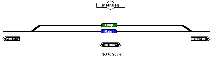
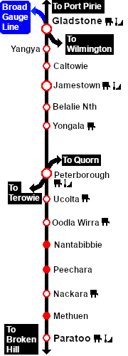
| − | + | <span style="font-weight: 700;"><span style="color: white; background-color: black;"> Distance from Peterborough: </span> 54 kms, 33½ miles</span><br> | |
| − | + | Unmanned location on the <span style="font-weight: 700; color: white; background-color: black;"> Port Pirie-Broken Hill Line </span>.<br> | |
| − | + | ||
| − | + | Crossing loop.<br> | |
| − | + | ||
| − | + | The loop was removed when the line was converted to standard gauge (4ft8½in - 1435mm) during 1969-1970. | |
| − | + | </td> | |
</tr> | </tr> | ||
<tr valign="top"> | <tr valign="top"> | ||
| − | <td | + | <td align="center">[[Image:line740.png|link=]]</td> |
</tr> | </tr> | ||
| − | </table> <!-- END | + | |
| + | </table> <!-- END Information Table --> | ||
</td> | </td> | ||
Latest revision as of 10:55, 1 May 2024
|
 |