|
|
| (16 intermediate revisions by one user not shown) |
| Line 3: |
Line 3: |
| | <td width=750> | | <td width=750> |
| | | | |
| − | <table bgcolor="lightgrey" bordercolor="lightgrey" width=750> <!-- BEGIN Location details table --> | + | <table width=750> <!-- BEGIN TABBED link list with Home page active--> |
| | + | <tr valign="top"> |
| | + | <td align="center">[[Image:line740.png|link=]]</td> |
| | + | </tr> |
| | + | <tr valign="top"> |
| | + | <td align="center">[[image:Tab_HM_White.png|link=]] [[image:Tab_IN_Grey.png|link=SAR_Yangya_Industry]] [[image:Tab_TM_Grey.png|link=SAR_Yangya_TrackMarks]] [[image:Tab_SW_Grey.png|link=SAR_Yangya_Switches]] [[image:Tab_Blank_Grey.png|link=]]</td> |
| | + | </tr> |
| | + | <tr valign="top"> |
| | + | <td align="center">[[Image:line740.png|link=]]</td> |
| | + | </tr> |
| | + | </table> <!-- END TABBED link list --> |
| | + | |
| | + | <table bgcolor="lightgrey" bordercolor="lightgrey" width=750> <!-- BEGIN Location link table with LINE and STATION NAMES --> |
| | | | |
| | <tr valign="middle"> | | <tr valign="middle"> |
| | <td width=220 align="right">[[Image:SAR_PortPirie-BrokenHill_Line.png|link=SAR_Port_Pirie-Broken_Hill|alt=PortPirie-BrokenHill|Show Port Pirie-Broken Hill]]</td> | | <td width=220 align="right">[[Image:SAR_PortPirie-BrokenHill_Line.png|link=SAR_Port_Pirie-Broken_Hill|alt=PortPirie-BrokenHill|Show Port Pirie-Broken Hill]]</td> |
| | <td width=110 align="center">[[Image:Next Left.png|link=|alt=]]<br>[[Image:SAR_Gladstone_W_Name.png|link=SAR Gladstone|alt=Gladstone|Next Up Location]]</td> | | <td width=110 align="center">[[Image:Next Left.png|link=|alt=]]<br>[[Image:SAR_Gladstone_W_Name.png|link=SAR Gladstone|alt=Gladstone|Next Up Location]]</td> |
| − | <td width=90 align="center">[[Image:Location Index.png|link=SAR Index|alt=Location Index|Location Index]]</td> | + | <td width=90 align="center">[[Image:Location Index.png|link=SAR Index|alt=Location Index|Location Index]]<br>[[image:Scenario Index.png|link=SAR Peterborough Base Session|alt=Scenarios]]</td> |
| | <td width=110 align="center">[[Image:Next Right.png|link=|alt=]]<br>[[Image:SAR_Caltowie_Name.png|link=SAR Caltowie|alt=Caltowie|Next Down Location]]</td> | | <td width=110 align="center">[[Image:Next Right.png|link=|alt=]]<br>[[Image:SAR_Caltowie_Name.png|link=SAR Caltowie|alt=Caltowie|Next Down Location]]</td> |
| | <td width=220 align="left">[[Image:SAR_PortPirie-BrokenHill_Line.png|link=SAR_Port_Pirie-Broken_Hill|alt=PortPirie-BrokenHill|Show Port Pirie-Broken Hill]]</td> | | <td width=220 align="left">[[Image:SAR_PortPirie-BrokenHill_Line.png|link=SAR_Port_Pirie-Broken_Hill|alt=PortPirie-BrokenHill|Show Port Pirie-Broken Hill]]</td> |
| | </tr> | | </tr> |
| − | <tr valign="top">
| |
| − | <td colspan=5>'''Commodities: (load and/or unload)'''
| |
| | | | |
| − | <table> <!-- BEGIN Commodities table 1 --> | + | </table> <!-- END Location link table with LINE and STATION NAMES --> |
| − | <tr valign="top">
| + | |
| − | <td align="center">[[Image:Passenger_Icon.png|link=|alt=Passengers]]<br><span style="font-size: 10px; font-weight: 700;">Passengers</span><br>[[image:Station_Label.png|link=]]</td>
| + | |
| − | </tr>
| + | |
| − | </table></td> <!-- END Commodities Table 1 -->
| + | |
| − | </tr>
| + | |
| | | | |
| − | </table> <!-- END Location details table -->
| + | [[image:SAR_Yangya.png|link=|alt=Yangya map]] |
| | | | |
| − | <table> <!-- BEGIN Information Table --> | + | <table bgcolor="lightgrey" bordercolor="lightgrey" width=750> <!-- BEGIN Location details table --> |
| | | | |
| | <tr valign="top"> | | <tr valign="top"> |
| − | <td width=750> | + | <td><span style="font-weight: 700; background-color: black; color: white;"> Commodities: </span> |
| − | Short station and siding loops. Unmanned station on the <span style="font-weight: 700; color: white; background-color: black;"> Port Pirie-Broken Hill Line </span>. This location was bypassed when the line was converted to standard gauge in 1969.
| + | |
| − | </td>
| + | |
| − | </tr>
| + | |
| − | <tr valign="top">
| + | |
| − | <td align="center">[[Image:line740.png|link=]]</td>
| + | |
| − | </tr>
| + | |
| − | | + | |
| − | </table> <!-- END Information Table -->
| + | |
| | | | |
| − | <table width=750> <!-- BEGIN Track Title Link --> | + | <table width=300> <!-- BEGIN Commodities table (5 items) --> |
| | <tr valign="top"> | | <tr valign="top"> |
| − | <td width=450>{{Anchor|TrackData}}<span style="font-weight: 700; font-size: 18px; background-color: blue; color: white;"> Track Diagram and Track Markers </span></td>
| |
| − | <td align=right width=300>[[image:ToPathsDown.png|link=#PathData]] [[file:BackToTop.png|link=#top]] [[file:BackToBottom.png|link=#BaseData]]</td>
| |
| − | </tr>
| |
| − | </table> <!-- END Track Title Link -->
| |
| | | | |
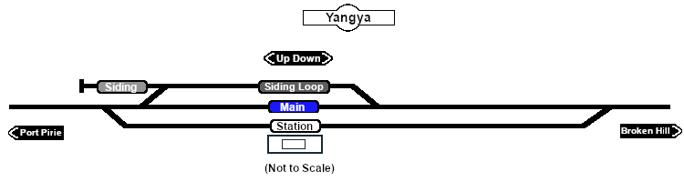
| − | [[Image:SAR_Yangya_Basic.png|link=|alt=Yangya Track Diagram]]<br> <!-- Track map --> | + | <td align="center" width=50>[[Image:Passenger_Icon_off.png|link=|alt=Passengers]]<br><span style="font-size: 10px; font-weight: 700;">Passengers</span><br>[[image:Station_Label.png|link=]]</td> |
| | + | <td align="center" width=50> </td> <!-- holding space 2 --> |
| | + | <td align="center" width=50> </td> <!-- holding space 3 --> |
| | + | <td align="center" width=50> </td> <!-- holding space 4 --> |
| | + | <td align="center" width=50> </td> <!-- holding space 5 --> |
| | | | |
| − | <table bgcolor="LightYellow" width=750> <!-- BEGIN Track Markers table -->
| |
| − | <tr valign="top">
| |
| − | <td colspan=4 align="center">[[Image:line740.png|link=]]</td>
| |
| | </tr> | | </tr> |
| − | <tr valign="middle">
| + | </table> <!-- END Commodities Table --> |
| − | <td colspan=3 align="center"><span style="font-weight: 700;font-size: 17px; background-color: red; color: white;"> Track Markers </span></td>
| + | |
| − | </tr>
| + | |
| − | <tr valign="middle">
| + | |
| − | <td colspan=3 align="center"><span style="font-weight: 700;">Destinations for "Drive To Trackmark ..." commands</span></td>
| + | |
| − | </tr>
| + | |
| − | <tr valign="middle">
| + | |
| − | <td width=200><span style="font-weight: 700; background-color: black; color: white;"> Approach from Port Pirie </span> </td>
| + | |
| − | <td colspan=2>[[image:Trackmark_Right.png|link=|alt=TM|10px]] <span style="font-weight: 700;">Yangya Main Approach Dn</span></td>
| + | |
| − | </tr>
| + | |
| − | <tr valign="middle">
| + | |
| − | <td width=200><span style="font-weight: 700; background-color: black; color: white;"> Approach from Broken Hill </span> </td>
| + | |
| − | <td colspan=2>[[image:Trackmark_Left.png|link=|alt=TM|10px]] <span style="font-weight: 700;">Yangya Main Approach Up</span></td>
| + | |
| − | </tr>
| + | |
| − | <tr valign="middle">
| + | |
| − | <td width=200>[[image:Station_Label.png|link=|alt=Station]] </td>
| + | |
| − | <td>[[image:Trackmark_Left.png|link=|alt=TM|10px]] <span style="font-weight: 700;">Yangya Station Up</span></td>
| + | |
| − | <td>[[image:Trackmark_Right.png|link=|alt=TM|10px]] <span style="font-weight: 700;">Yangya Station Dn</span></td>
| + | |
| − | </tr>
| + | |
| − | <tr valign="middle">
| + | |
| − | <td width=200>[[image:Main_Label.png|link=|alt=Main]] </td>
| + | |
| − | <td>[[image:Trackmark_Left.png|link=|alt=TM|10px]] <span style="font-weight: 700;">Yangya Main Up</span></td>
| + | |
| − | <td>[[image:Trackmark_Right.png|link=|alt=TM|10px]] <span style="font-weight: 700;">Yangya Main Dn</span></td>
| + | |
| − | </tr>
| + | |
| − | <tr valign="middle">
| + | |
| − | <td width=200>[[image:Siding_Label.png|link=|alt=Main]] </td>
| + | |
| − | <td>[[image:Trackmark_Left.png|link=|alt=TM|10px]] <span style="font-weight: 700;">Yangya Siding Up</span></td>
| + | |
| − | <td>[[image:Trackmark_Right.png|link=|alt=TM|10px]] <span style="font-weight: 700;">Yangya Siding Dn</span></td>
| + | |
| − | </tr>
| + | |
| − | </table> <!-- END Track Markers table --> | + | |
| | | | |
| − | <table bgcolor="LightYellow" width=750> <!-- BEGIN Switches table -->
| + | </td> |
| − | <tr valign="top">
| + | <td> |
| − | <td colspan=6 align="center">[[Image:line740.png|link=]]</td>
| + | |
| − | </tr>
| + | |
| − | <tr valign="top">
| + | |
| − | <td align="center" colspan=6><span style="font-size: 17px; font-weight: 700; color: white; background-color: black;"> Switches </span></td>
| + | |
| − | </tr>
| + | |
| − | <tr valign="top">
| + | |
| − | <td align="center" valign="top" width=50><span style="font-size: 17px; font-weight: 700;">No.</span></td>
| + | |
| − | <td align="left" valign="top" width=80><span style="font-size: 17px; font-weight: 700;">Name</span></td>
| + | |
| − | <td align="left" valign="top" width=245><span style="font-size: 17px; font-weight: 700;">Facing and L/R Directions</span><br>'''(default direction first)'''</td>
| + | |
| − | </tr>
| + | |
| − | <tr valign="top">
| + | |
| − | <td colspan=6 align="center">[[Image:line740.png|link=]]</td>
| + | |
| − | </tr>
| + | |
| − | <tr valign="top">
| + | |
| − | <td align="center">[[Image:No_1.png|20px|link=]]</td>
| + | |
| − | <td>'''YY 1'''</td>
| + | |
| − | <td><span style="background-color: yellow; font-weight: 700;">Down</span> '''(L) Main, (R) Station'''</td>
| + | |
| − | <td align="center">[[Image:No_2.png|20px|link=]]</td>
| + | |
| − | <td>'''YY 2'''</td>
| + | |
| − | <td><span style="background-color: yellow; font-weight: 700;">Down</span> '''(R) Main, (L) Siding Loop'''</td>
| + | |
| − | </tr>
| + | |
| − | <tr valign="top">
| + | |
| − | <td align="center">[[Image:No_3.png|20px|link=]]</td>
| + | |
| − | <td>'''YY 3'''</td>
| + | |
| − | <td><span style="background-color: cyan; font-weight: 700;">Up</span> '''(R) Siding, (L) Main'''</td>
| + | |
| − | <td align="center">[[Image:No_4.png|20px|link=]]</td>
| + | |
| − | <td>'''YY 4'''</td>
| + | |
| − | <td><span style="background-color: cyan; font-weight: 700;">Up</span> '''(L) Main, (R) Siding Loop'''</td>
| + | |
| − | </tr>
| + | |
| − | <tr valign="top">
| + | |
| − | <td align="center">[[Image:No_5.png|20px|link=]]</td>
| + | |
| − | <td>'''YY 5'''</td>
| + | |
| − | <td><span style="background-color: cyan; font-weight: 700;">Up</span> '''(R) Main, (L) Station'''</td>
| + | |
| − | <td colspan=3> </td>
| + | |
| − | </tr>
| + | |
| − | <tr valign="top">
| + | |
| − | <td colspan=6 align="center">[[Image:line740.png|link=]]</td>
| + | |
| − | </tr>
| + | |
| − | <tr valign="middle">
| + | |
| − | <td colspan=6 align="center"><span style="font-weight: 700;font-size: 17px; background-color: black; color: white;"> Switch Sets </span></td>
| + | |
| − | </tr>
| + | |
| − | <tr valign="top">
| + | |
| − | <td colspan=6> | + | |
| | | | |
| − | <table width=750> <!-- BEGIN Switch Sets Station table --> | + | <table width=175> <!-- BEGIN Loco table (3 items) --> |
| | <tr valign="top"> | | <tr valign="top"> |
| | | | |
| − | <td width=150><span style="font-weight: 700;"><span style="background-color: black; color: white;"> Port Pirie - </span><span style="background-color: white; color: black;"> Station </span></span></td> | + | <td width=175> </td> <!-- holding space 1-3 for no Loco items --> |
| − | | + | |
| − | <td width=225><span style="font-weight: 700;"><span style="background-color: black; color: yellow;"> 1 </span>-R </span></td> | + | |
| − | | + | |
| − | <td width=150><span style="font-weight: 700;"><span style="background-color: black; color: white;"> Broken Hill - </span><span style="background-color: white; color: black;"> Station </span></span></td>
| + | |
| − | | + | |
| − | <td width=225><span style="font-weight: 700;"><span style="background-color: black; color: yellow;"> 1 </span>-L <span style="background-color: black; color: yellow;"> 2 </span>-R </span></td>
| + | |
| | | | |
| | </tr> | | </tr> |
| − | </table> <!-- END Switch Sets Station table --> | + | </table> <!-- END Loco table --> |
| | | | |
| − | <table> <!-- BEGIN Switch Sets Siding table --> | + | </td> |
| − | <tr valign="top"> | + | <td> |
| | | | |
| − | <td width=150><span style="font-weight: 700;"><span style="background-color: black; color: white;"> Port Pirie - </span><span style="background-color: #949494; color: white;"> Siding </span></span></td> | + | <table width=250> <!-- BEGIN Facilities table (4 items) --> |
| − | | + | |
| − | <td width=225><span style="font-weight: 700;"><span style="background-color: black; color: yellow;"> 1 </span>-L <span style="background-color: black; color: yellow;"> 2 </span>-L <span style="background-color: black; color: yellow;"> 3 </span>-L </span></td>
| + | |
| − | | + | |
| − | <td width=150><span style="font-weight: 700;"><span style="background-color: black; color: white;"> Broken Hill - </span><span style="background-color: #949494; color: white;"> Siding </span></span></td>
| + | |
| − | | + | |
| − | <td width=225><span style="font-weight: 700;"><span style="background-color: black; color: yellow;"> 5 </span>-R <span style="background-color: black; color: yellow;"> 4 </span>-R </span></td>
| + | |
| − | | + | |
| − | </tr>
| + | |
| − | </table> <!-- END Switch Sets Siding table -->
| + | |
| − | | + | |
| − | <table> <!-- BEGIN Switch Mainline table -->
| + | |
| | <tr valign="top"> | | <tr valign="top"> |
| | | | |
| − | <td width=150><span style="font-weight: 700;"><span style="background-color: black; color: white;"> Port Pirie - </span><span style="background-color: #1919fe; color: white;"> Main </span></span></td> | + | <td width=250> </td> <!-- holding space 1-4 for no Facility items --> |
| − | | + | |
| − | <td width=225><span style="font-weight: 700;"><span style="background-color: black; color: yellow;"> 5 </span>-L </span></td> | + | |
| − | | + | |
| − | <td width=150><span style="font-weight: 700;"><span style="background-color: black; color: white;"> Broken Hill - </span><span style="background-color: #1919fe; color: white;"> Main </span></span></td>
| + | |
| − | | + | |
| − | <td width=225><span style="font-weight: 700;"><span style="background-color: black; color: yellow;"> 5 </span>-R <span style="background-color: black; color: yellow;"> 4 </span>-L </span></td>
| + | |
| | | | |
| | </tr> | | </tr> |
| − | </table> <!-- END Switch Sets Mainline table --> | + | </table> <!-- END Facilities Table --> |
| | | | |
| | </td> | | </td> |
| | </tr> | | </tr> |
| − | <tr valign="top">
| + | </table> <!-- END Location details table --> |
| − | <td colspan=6 align="center">[[Image:line740.png|link=]]</td>
| + | |
| − | </tr> | + | |
| | | | |
| − | </table> <!-- END Switches table --> | + | <table> <!-- BEGIN Information Table --> |
| | | | |
| − | <table width=750> <!-- BEGIN Path Map Table -->
| |
| | <tr valign="top"> | | <tr valign="top"> |
| | <td width=750> | | <td width=750> |
| | + | <span style="font-weight: 700;"><span style="color: white; background-color: black;"> Distance from Gladstone: </span> 8 kms, 5 miles <span style="color: white; background-color: black;"> from Peterborough: </span> 57½ kms, 35¾ miles</span><br> |
| | | | |
| − | <table width=750> <!-- BEGIN Path Title Link -->
| + | Unmanned station on the <span style="font-weight: 700; color: white; background-color: black;"> Port Pirie-Broken Hill Line </span>.<br> |
| − | <tr valign="top">
| + | |
| − | <td width=450>{{Anchor|PathData}}<span style="font-weight: 700; font-size: 18px; background-color: blue; color: white;"> Path Diagrams </span></td>
| + | |
| − | <td align=right width=300>[[image:ToTracksUp.png|link=#TrackData]] [[file:BackToTop.png|link=#top]]</td>
| + | |
| − | </tr>
| + | |
| − | </table> <!-- END Path Title Link -->
| + | |
| | | | |
| − | [[Image:SAR_Yangya.png|link=|alt=Yangya Path Map]]<br> <!-- Path map -->
| + | Short station and siding loops. Not rated as a crossing loop.<br> |
| | | | |
| | + | This location was bypassed when the line was converted to standard gauge (4ft8½in - 1435mm) in 1969-1970. |
| | </td> | | </td> |
| | </tr> | | </tr> |
| − | </table> <!-- END Path Map Table -->
| |
| − |
| |
| − | <table bgcolor="LightYellow"> <!-- BEGIN Paths Table -->
| |
| − |
| |
| | <tr valign="top"> | | <tr valign="top"> |
| − | <td colspan=4 align="center">[[Image:line740.png|link=]]</td> | + | <td align="center">[[Image:line740.png|link=]]</td> |
| − | </tr>
| + | |
| − | <tr valign="top" bgcolor="black">
| + | |
| − | <td align="center" width=50><span style="font-size: 17px; font-weight: 700; color: white;"> From </span></td>
| + | |
| − | <td align="center" width=50><span style="font-size: 17px; font-weight: 700; color: white;">To</span></td>
| + | |
| − | <td align="center" width=225><span style="font-size: 17px; font-weight: 700; color: white;">EIT Paths</span></td>
| + | |
| − | <td align="center" width=425><span style="font-size: 17px; font-weight: 700; color: white;">Descriptions</span></td>
| + | |
| − | </tr>
| + | |
| − | <tr valign="middle">
| + | |
| − | <td align="center" colspan=2 bgcolor="cyan">[[Image:Ablue.png|link=]] [[Image:Bblue.png|link=]]</td>
| + | |
| − | <td>'''Port Pirie to Broken Hill'''</td>
| + | |
| − | <td>'''Through (non stopping) service from Gladstone to Jamestown or Peterborough'''</td>
| + | |
| − | </tr>
| + | |
| − | <tr valign="middle">
| + | |
| − | <td align="center" colspan=2 bgcolor="cyan">[[Image:Ablue.png|link=]] [[Image:Cred.png|link=]] [[Image:Bblue.png|link=]]</td>
| + | |
| − | <td>'''Port Pirie to Station to Broken Hill'''</td>
| + | |
| − | <td>'''Through service from Gladstone to Jamestown or Peterborough stopping at station'''</td>
| + | |
| − | </tr>
| + | |
| − | <tr valign="middle">
| + | |
| − | <td align="center" colspan=2 bgcolor="green">[[Image:Ablue.png|link=]] [[Image:Dgreen.png|link=]]</td>
| + | |
| − | <td>'''Port Pirie to Siding'''</td>
| + | |
| − | <td>'''Arriving service from Gladstone to siding'''</td>
| + | |
| − | </tr>
| + | |
| − | <tr valign="middle">
| + | |
| − | <td align="center" colspan=2 bgcolor="green">[[Image:Egreen.png|link=]] [[Image:Bblue.png|link=]]</td>
| + | |
| − | <td>'''Siding to Broken Hill'''</td>
| + | |
| − | <td>'''Departing service to Jamestown or Peterborough from siding'''</td>
| + | |
| − | </tr>
| + | |
| − | <tr valign="middle">
| + | |
| − | <td colspan=4 align="center"><span style="font-weight: 700;">All reverse paths (e.g. [[Image:Bblue.png|link=]] to [[Image:Ablue.png|link=]]) are also available</span></td></tr>
| + | |
| − | <tr valign="top">
| + | |
| − | <td colspan=4 align="center">[[Image:line740.png|link=]]</td>
| + | |
| | </tr> | | </tr> |
| | | | |
| − | </table> <!-- END Paths Table --> | + | </table> <!-- END Information Table --> |
| | | | |
| | </td> | | </td> |
| | <td> | | <td> |
| | + | [[Image:SAR_PortPirie-BrokenHill_Line.png|link=SAR_Port_Pirie-Broken_Hill|alt=PortPirie-BrokenHill|Show Port Pirie-Broken Hill]]<br> |
| | [[Image:SAR_Gladstone-Paratoo Strip Map.png|link=|alt=Gladstone-Paratoo Strip Map]]</td> | | [[Image:SAR_Gladstone-Paratoo Strip Map.png|link=|alt=Gladstone-Paratoo Strip Map]]</td> |
| | </tr> | | </tr> |
| | </table> <!-- END TOP TABLE --> | | </table> <!-- END TOP TABLE --> |
| − | {{Anchor|BaseData}}
| |