SAR Wallaway
m |
m |
||
| (39 intermediate revisions by one user not shown) | |||
| Line 1: | Line 1: | ||
| − | + | <table> <!-- BEGIN TOP TABLE --> | |
| − | + | <tr valign="top"> | |
| − | + | <td width=750> | |
| − | <table> | + | <table width=750> <!-- BEGIN TABBED link list with Home page active--> |
<tr valign="top"> | <tr valign="top"> | ||
| − | <td | + | <td align="center">[[Image:line740.png|link=]]</td> |
| − | + | ||
| − | + | ||
| − | + | ||
| − | + | ||
| − | + | ||
</tr> | </tr> | ||
| − | < | + | <tr valign="top"> |
| − | + | <td align="center">[[image:Tab_HM_White.png|link=]] [[image:Tab_IN_Grey.png|link=SAR_Wallaway_Industry]] [[image:Tab_TM_Grey.png|link=SAR_Wallaway_TrackMarks]] [[image:Tab_SW_Grey.png|link=SAR_Wallaway_Switches]] [[image:Tab_Blank_Grey.png|link=]]</td> | |
| − | + | ||
| − | <td | + | |
</tr> | </tr> | ||
<tr valign="top"> | <tr valign="top"> | ||
| − | <td | + | <td align="center">[[Image:line740.png|link=]]</td> |
| − | + | ||
| − | + | ||
| − | + | ||
| − | + | ||
| − | + | ||
| − | + | ||
| − | + | ||
| − | + | ||
</tr> | </tr> | ||
| + | </table> <!-- END TABBED link list --> | ||
| + | |||
| + | <table bgcolor="lightgrey" bordercolor="lightgrey" width=750> <!-- BEGIN Location link table with LINE and STATION NAMES --> | ||
| + | |||
<tr valign="middle"> | <tr valign="middle"> | ||
| − | <td align=" | + | <td width=220 align="right">[[Image:SAR_Peterborough-Quorn_Line.png|link=SAR Peterborough-Quorn|alt=Peterborough-Quorn|Show Peterborough-Quorn]]</td> |
| − | <td align="center">[[Image: | + | <td width=110 align="center">[[Image:Next Left.png|link=|alt=]]<br>[[Image:SAR_Orroroo_Name.png|link=SAR Orroroo|alt=Orroroo|Next Up Location]]</td> |
| − | <td | + | <td width=90 align="center">[[Image:Location Index.png|link=SAR Index|alt=Location Index|Location Index]]<br>[[image:Scenario Index.png|link=SAR Peterborough Base Session|alt=Scenarios]]</td> |
| − | <td align="center">[[Image: | + | <td width=110 align="center">[[Image:Next Right.png|link=|alt=]]<br>[[Image:SAR_Halls_Well_Name.png|link=SAR Halls Well|alt=Halls Well|Next Down Location]]</td> |
| − | + | <td width=220 align="left">[[Image:SAR_Peterborough-Quorn_Line.png|link=SAR Peterborough-Quorn|alt=Peterborough-Quorn|Show Peterborough-Quorn]]</td> | |
| − | <td | + | |
</tr> | </tr> | ||
| − | <tr valign=" | + | |
| − | <td align="center">[[Image: | + | </table> <!-- END Location link table with LINE and STATION NAMES --> |
| − | < | + | |
| − | <td | + | [[image:SAR_Wallaway.png|link=|alt=Wallaway map]] |
| − | <td align="center" | + | |
| − | <td align="center" | + | <table bgcolor="lightgrey" bordercolor="lightgrey" width=750> <!-- BEGIN Location details table --> |
| − | <td | + | |
| + | <tr valign="top"> | ||
| + | <td><span style="font-weight: 700; background-color: black; color: white;"> Commodities: </span> | ||
| + | |||
| + | <table width=300> <!-- BEGIN Commodities table (5 items) --> | ||
| + | <tr valign="top"> | ||
| + | |||
| + | <td align="center" width=50>[[Image:Goods_Icon.png|link=|alt=Goods]]<br><span style="font-size: 10px; font-weight: 700;">Goods</span><br>[[image:Goods_Label.png|link=]]</td> | ||
| + | <td align="center" width=50> </td> <!-- holding space 2 --> | ||
| + | <td align="center" width=50> </td> <!-- holding space 3 --> | ||
| + | <td align="center" width=50> </td> <!-- holding space 4 --> | ||
| + | <td align="center" width=50> </td> <!-- holding space 5 --> | ||
| + | |||
</tr> | </tr> | ||
| − | < | + | </table> <!-- END Commodities Table --> |
| − | < | + | |
| − | < | + | </td> |
| − | < | + | <td> |
| − | < | + | |
| − | <td | + | <table width=175> <!-- BEGIN Loco table (3 items) --> |
| − | < | + | <tr valign="top"> |
| + | |||
| + | <td width=175> </td> <!-- holding space 1-3 for no Loco items - REMOVE black background and "Loco Serices" label --> | ||
| + | |||
</tr> | </tr> | ||
| − | < | + | </table> <!-- END Loco table --> |
| − | < | + | |
| − | < | + | </td> |
| − | < | + | <td> |
| − | < | + | |
| − | <td | + | <table width=250> <!-- BEGIN Facilities table (4 items) --> |
| − | < | + | <tr valign="top"> |
| + | |||
| + | <td width=250> </td> <!-- holding space 1-4 for no Facility items - REMOVE "Facilities" label --> | ||
| + | |||
</tr> | </tr> | ||
| − | + | </table> <!-- END Facilities Table --> | |
| − | + | ||
| − | < | + | </td> |
| − | + | ||
| − | + | ||
| − | + | ||
| − | + | ||
</tr> | </tr> | ||
| − | <tr> | + | </table> <!-- END Location details table --> |
| − | <td | + | |
| + | <table> <!-- BEGIN Information Table --> | ||
| + | |||
| + | <tr valign="top"> | ||
| + | <td width=750> | ||
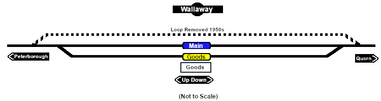
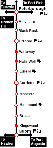
| + | Unmanned location on the <span style="font-weight: 700; color: white; background-color: black;"> Peterborough-Quorn Line </span>.<br> | ||
| + | |||
| + | A goods loop with a small goods shed was the only structure. A passing loop was removed during the 1950s due to the reduction in traffic on the line.<br> | ||
| + | |||
| + | Just south (on the '''Peterborough''' side) of '''Wallaway''' is a culvert that was the site of the only serious incident on the line - a head on collision between two trains in the early hours of Saturday 16th November 1901. The firemen on both locos were killed and the drivers injured.<br> | ||
| + | |||
| + | The line from '''Peterborough''' to '''Eurelia''' was closed to normal traffic in 1988 and was fully closed in 2002. Most of the track was removed in 2008. At '''Wallaway''' the culvert at the accident site and the track back to the yard have been preserved. A monument has been constructed at the site from materials retrieved from the goods shed when it was demolished. | ||
| + | </td> | ||
</tr> | </tr> | ||
| − | </table></td> | + | |
| + | <tr valign="top"> | ||
| + | <td align="center">[[Image:line740.png|link=]]</td> | ||
| + | </tr> | ||
| + | |||
| + | </table> <!-- END Information Table --> | ||
| + | |||
| + | </td> | ||
<td> | <td> | ||
| − | [[ | + | [[Image:SAR_Peterborough-Quorn_Line.png|link=SAR_Peterborough-Quorn|alt=Peterborough-Quorn|Show Peterborough-Quorn]]<br> |
| + | [[Image:SAR_Peterborough-Quorn Strip Map.png|link=|alt=Peterborough-Quorn Strip Map]]</td> | ||
</tr> | </tr> | ||
| − | </table> | + | </table> <!-- END TOP TABLE --> |
Revision as of 20:52, 24 June 2022
|
 |