Help/Topology Tab
From TrainzOnline
< Help(Difference between revisions)
| Line 1: | Line 1: | ||
| − | + | The Topology Menu provides | |
| − | + | the tools for creating various | |
| − | [[File:Topology.jpeg|400px| | + | types of terrain. In this section |
| + | you will learn how to make | ||
| + | hills, valleys, mountains, lakes | ||
| + | and rivers. | ||
| + | |||
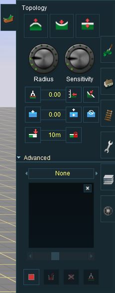
| + | Click on the Topology Tab (or | ||
| + | press the F1 key) to open the | ||
| + | Topology Menu. Here you | ||
| + | will see a number of different | ||
| + | tools that can be used to shape | ||
| + | the terrain. Hold your mouse | ||
| + | cursor over each one to see a | ||
| + | short description as well as the | ||
| + | appropriate Hotkey to press. To | ||
| + | see the whole menu as in the | ||
| + | diagram above, click on the | ||
| + | “Advanced” button to expand | ||
| + | the menu. | ||
| + | [[File:Topology.jpeg|400px|right]] | ||
{{clear}} | {{clear}} | ||
| + | |||
| + | = Main menu = | ||
| + | |||
| + | == Height up == | ||
| + | |||
[[File:Height up.jpg]] | [[File:Height up.jpg]] | ||
{{clear}} | {{clear}} | ||
| + | |||
| + | == Height down == | ||
| + | |||
[[File:Height down.jpg]] | [[File:Height down.jpg]] | ||
{{clear}} | {{clear}} | ||
| + | |||
| + | == Height adjust == | ||
| + | |||
[[File:Height adjust.jpg]] | [[File:Height adjust.jpg]] | ||
{{clear}} | {{clear}} | ||
| + | |||
| + | == Radius == | ||
| + | |||
[[File:Radius.jpg]] | [[File:Radius.jpg]] | ||
{{clear}} | {{clear}} | ||
| + | |||
| + | == Sensitivity == | ||
| + | |||
[[File:Sensitivity.jpg]] | [[File:Sensitivity.jpg]] | ||
{{clear}} | {{clear}} | ||
| + | |||
| + | == Get height == | ||
| + | |||
[[File:Height get.jpg]] | [[File:Height get.jpg]] | ||
{{clear}} | {{clear}} | ||
| + | |||
| + | == Use height == | ||
| + | |||
[[File:Height use.jpg]] | [[File:Height use.jpg]] | ||
{{clear}} | {{clear}} | ||
| + | |||
| + | == Plateu == | ||
| + | |||
[[File:Plateu.jpg]] | [[File:Plateu.jpg]] | ||
{{clear}} | {{clear}} | ||
| + | |||
| + | == Add water == | ||
| + | |||
[[File:Water add.jpg]] | [[File:Water add.jpg]] | ||
{{clear}} | {{clear}} | ||
| + | |||
| + | == Remove water == | ||
| + | |||
[[File:Water remove.jpg]] | [[File:Water remove.jpg]] | ||
{{clear}} | {{clear}} | ||
| + | |||
| + | == Adjust water height == | ||
| + | |||
[[File:Water adjust height.jpg]] | [[File:Water adjust height.jpg]] | ||
{{clear}} | {{clear}} | ||
| + | |||
| + | == Add ground == | ||
| + | |||
[[File:Ground add.jpg]] | [[File:Ground add.jpg]] | ||
{{clear}} | {{clear}} | ||
| + | |||
| + | == Remove ground == | ||
| + | |||
[[File:Ground remove.jpg]] | [[File:Ground remove.jpg]] | ||
{{clear}} | {{clear}} | ||
| − | + | = Advanced = | |
| + | |||
| + | == Displacement map == | ||
| + | |||
[[File:Displacement map.jpg]] | [[File:Displacement map.jpg]] | ||
{{clear}} | {{clear}} | ||
| + | |||
| + | == Direction == | ||
| + | |||
[[File:Direction.jpg]] | [[File:Direction.jpg]] | ||
{{clear}} | {{clear}} | ||
| + | |||
| + | == Threshold == | ||
| + | |||
[[File:Threshold.jpg]] | [[File:Threshold.jpg]] | ||
{{clear}} | {{clear}} | ||
| + | |||
| + | == Select area == | ||
| + | |||
[[File:Area select.jpg]] | [[File:Area select.jpg]] | ||
{{clear}} | {{clear}} | ||
| + | |||
| + | == Fill area == | ||
| + | |||
[[File:Area fill.jpg]] | [[File:Area fill.jpg]] | ||
{{clear}} | {{clear}} | ||
| + | |||
| + | == Cancel selection == | ||
| + | |||
[[File:Area cancel.jpg]] | [[File:Area cancel.jpg]] | ||
{{clear}} | {{clear}} | ||
| + | |||
| + | == Get displacement == | ||
| + | |||
[[File:Area grab.jpg]] | [[File:Area grab.jpg]] | ||
{{clear}} | {{clear}} | ||
Revision as of 08:37, 17 February 2014
The Topology Menu provides the tools for creating various types of terrain. In this section you will learn how to make hills, valleys, mountains, lakes and rivers.
Click on the Topology Tab (or press the F1 key) to open the Topology Menu. Here you will see a number of different tools that can be used to shape the terrain. Hold your mouse cursor over each one to see a short description as well as the appropriate Hotkey to press. To see the whole menu as in the diagram above, click on the “Advanced” button to expand the menu.
Contents |
Height up
Height down
Height adjust
Radius
Sensitivity
Get height
Use height
Plateu
Add water
Remove water
Adjust water height
Add ground
Remove ground


